
The UTM Grid - Civilian UTM Grid Reference
Two systems are marked on NTS maps for identifying points with reference to the rectangular grid: Civilian UTM Grid Reference System described below and Military Grid Reference System.
On the Civilian UTM Grid Reference System, horizontal lines are designated by their distance from the equator in metres. Because Canada's southernmost point is about 4 620 000 metres from the equator, all horizontal lines in Canada have a "northing" value above that figure. Vertical lines are measured from a separate point for each zone, namely, an imaginary line lying 500 000 metres west of the zone's central meridian. Actually, zones never attain the full width of 1 000 000 metres which such a measurement suggests; in fact, in northern Canada, zone widths shrink to as little as 80 000 metres (40 000 metres on either side of the central meridian). In practice, this means that vertical lines are counted from the central meridian or 500 000 metre line, those to the left of it having an "easting" value of less than 500 000 metres, and those on the right having a value above that.
The number of metres north of the equator represented by the bottom horizontal grid line on a map is always shown in the lower left-hand corner of the map. Similarly, the number of metres east of the zero vertical line represented by the left vertical grid line is also shown in the lower left-hand corner.
If a given point on a map is positioned exactly at the intersection of a vertical and horizontal line, its location may be read off simply from the map margins. Its full designation or its "coordinates" would include the zone number, followed by the easting and northing values. On a 1 000-metre grid, these coordinates might read: Zone 14, 357 000, 5 476 000. The values of the first vertical and horizontal lines appearing in the southwest corner of the map are given in full. The other grid lines are numbered in an abbreviated fashion.
Few points, however, are conveniently located at grid intersections. Usually the point to be described (such as the church in Figure 1) is somewhere between lines. In this case, it is necessary to measure or estimate the distance to the nearest vertical line to the west and to the nearest horizontal line to the south and to add these metric values to the grid values given at the margin.
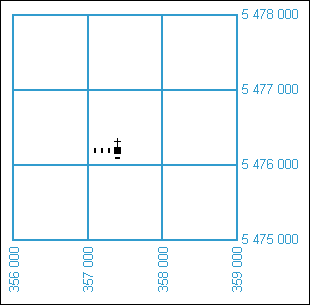
Figure 1 - Civilian System
Figure 1 - Text version
Figure 1 is an illustration of a church superimposed over a UTM grid which makes it possible to determine its coordinates.
As in the above example, if a point is located 400 metres east of the vertical line of 357 000, and 200 metres north of the horizontal line of 5 476 000, its coordinates would be: Zone 14, 357 400, 5 476 200. With these three numbers, any point on the northern hemisphere can be unmistakably identified. There is a similar reference in the southern hemisphere, but confusion never results from this.
The civilian system of designating UTM Grid coordinates is straightforward and, since it uses only numbers, it can be handled by digital mapping software and Geographic Information Systems (GIS), an important consideration with any kind of technical data. It does, however, require the use of large and somewhat cumbersome figures. To get around this, military map-makers have developed a somewhat different system consisting of a combination of letter and numbers, the Military Grid Reference System.
To help you understand what topographic maps are and how to use them, see National Topographic System (NTS) and The basics.
This material updated from The Universal Transverse Mercator Grid, Department of Energy, Mines and Resources Canada, Surveys and Mapping Branch, Ottawa, © 1969, The Queen's Printer.
Find out more
Page details
- Date modified: