
Microwave remote sensing
Introduction
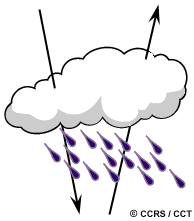 Microwave sensing encompasses both active and passive forms of remote sensing. As described in Chapter 2, the microwave portion of the spectrum covers the range from approximately 1cm to 1m in wavelength. Because of their long wavelengths, compared to the visible and infrared, microwaves have special properties that are important for remote sensing. Longer wavelength microwave radiation can penetrate through cloud cover, haze, dust, and all but the heaviest rainfall as the longer wavelengths are not susceptible to atmospheric scattering which affects shorter optical wavelengths. This property allows detection of microwave energy under almost all weather and environmental conditions so that data can be collected at any time.
Passive microwave sensing is similar in concept to thermal remote sensing. All objects emit microwave energy of some magnitude, but the amounts are generally very small. A passive microwave sensor detects the naturally emitted microwave energy within its field of view. This emitted energy is related to the temperature and moisture properties of the emitting object or surface. Passive microwave sensors are typically radiometers or scanners and operate in much the same manner as systems discussed previously except that an antenna is used to detect and record the microwave energy.
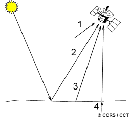
The microwave energy recorded by a passive sensor can be emitted by the atmosphere (1), reflected from the surface (2), emitted from the surface (3), or transmitted from the subsurface (4). Because the wavelengths are so long, the energy available is quite small compared to optical wavelengths. Thus, the fields of view must be large to detect enough energy to record a signal. Most passive microwave sensors are therefore characterized by low spatial resolution.
Applications of passive microwave remote sensing include meteorology, hydrology, and oceanography. By looking "at", or "through" the atmosphere, depending on the wavelength, meteorologists can use passive microwaves to measure atmospheric profiles and to determine water and ozone content in the atmosphere. Hydrologists use passive microwaves to measure soil moisture since microwave emission is influenced by moisture content. Oceanographic applications include mapping sea ice, currents, and surface winds as well as detection of pollutants, such as oil slicks.
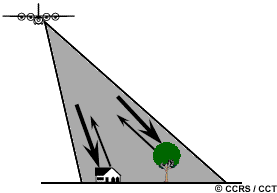 Active microwave sensors provide their own source of microwave radiation to illuminate the target. Active microwave sensors are generally divided into two distinct categories: imaging and non-imaging. The most common form of imaging active microwave sensors is RADAR. RADAR is an acronym for RAdio Detection And Ranging, which essentially characterizes the function and operation of a radar sensor. The sensor transmits a microwave (radio) signal towards the target and detects the backscattered portion of the signal. The strength of the backscattered signal is measured to discriminate between different targets and the time delay between the transmitted and reflected signals determines the distance (or range) to the target.
Non-imaging microwave sensors include altimeters and scatterometers. In most cases these are profiling devices which take measurements in one linear dimension, as opposed to the two-dimensional representation of imaging sensors. Radar altimeters transmit short microwave pulses and measure the round trip time delay to targets to determine their distance from the sensor. Generally altimeters look straight down at nadir below the platform and thus measure height or elevation (if the altitude of the platform is accurately known). Radar altimetry is used on aircraft for altitude determination and on aircraft and satellites for topographic mapping and sea surface height estimation. Scatterometers are also generally non-imaging sensors and are used to make precise quantitative measurements of the amount of energy backscattered from targets. The amount of energy backscattered is dependent on the surface properties (roughness) and the angle at which the microwave energy strikes the target. Scatterometry measurements over ocean surfaces can be used to estimate wind speeds based on the sea surface roughness. Ground-based scatterometers are used extensively to accurately measure the backscatter from various targets in order to characterize different materials and surface types. This is analogous to the concept of spectral reflectance curves in the optical spectrum.
For the remainder of this chapter we focus solely on imaging radars. As with passive microwave sensing, a major advantage of radar is the capability of the radiation to penetrate through cloud cover and most weather conditions. Because radar is an active sensor, it can also be used to image the surface at any time, day or night. These are the two primary advantages of radar: all-weather and day or night imaging. It is also important to understand that, because of the fundamentally different way in which an active radar operates compared to the passive sensors we described in Chapter 2, a radar image is quite different from and has special properties unlike images acquired in the visible and infrared portions of the spectrum. Because of these differences, radar and optical data can be complementary to one another as they offer different perspectives of the Earth's surface providing different information content. We will examine some of these fundamental properties and differences in more detail in the following sections.
Before we delve into the peculiarities of radar, let's first look briefly at the origins and history of imaging radar, with particular emphasis on the Canadian experience in radar remote sensing. The first demonstration of the transmission of radio microwaves and reflection from various objects was achieved by Hertz in 1886. Shortly after the turn of the century, the first rudimentary radar was developed for ship detection. In the 1920s and 1930s, experimental ground-based pulsed radars were developed for detecting objects at a distance. The first imaging radars used during World War II had rotating sweep displays which were used for detection and positioning of aircrafts and ships. After World War II, side-looking airborne radar (SLAR) was developed for military terrain reconnaissance and surveillance where a strip of the ground parallel to and offset to the side of the aircraft was imaged during flight. In the 1950s, advances in SLAR and the development of higher resolution synthetic aperture radar (SAR) were developed for military purposes. In the 1960s these radars were declassified and began to be used for civilian mapping applications. Since this time the development of several airborne and spaceborne radar systems for mapping and monitoring applications use has flourished.
Canada initially became involved in radar remote sensing in the mid-1970s. It was recognized that radar may be particularly well-suited for surveillance of our vast northern expanse, which is often cloud-covered and shrouded in darkness during the Arctic winter, as well as for monitoring and mapping our natural resources. Canada's SURSAT (Surveillance Satellite) project from 1977 to 1979 led to our participation in the (U.S.) SEASAT radar satellite, the first operational civilian radar satellite. The Convair-580 airborne radar program, carried out by the Canada Centre for Remote Sensing following the SURSAT program, in conjunction with radar research programs of other agencies such as NASA and the European Space Agency (ESA), led to the conclusion that spaceborne remote sensing was feasible. In 1987, the Radar Data Development Program (RDDP), was initiated by the Canadian government with the objective of "operationalizing the use of radar data by Canadians". Over the 1980s and early 1990s, several research and commercial airborne radar systems have collected vast amounts of imagery throughout the world demonstrating the utility of radar data for a variety of applications. With the launch of ESA's ERS-1 in 1991, spaceborne radar research intensified, and was followed by the major launches of Japan's J-ERS satellite in 1992, ERS-2 in 1995, and Canada's advanced RADARSAT satellite, also in 1995.
Did you know?
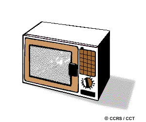
'S' band magnetrons are typically used for microwave oven power sources. They operate in the range of 2-4 GHz. The corresponding wavelengths are 15 cm to 7.5 cm. The screening mesh used on microwave oven doors is sufficiently fine (much smaller than 7.5 cm) that it behaves as a continuous, thin, metal sheet, preventing the escape of the radar energy, yet allowing good visibility of the interior (using visible wavelengths, which are much shorter yet).
Page details
- Date modified: