
Answer to question 5
The features in this radar image are:
- Hills with no apparent vegetation on them.
- Convection cells expressed on the ocean surface.
- Lines of sand dunes in a very arid part of the world.
- Glaciers in the northern part of Antarctica.
The answer is B.
A. No.
The sharp outlines to the features do not correspond to known hill shapes.
B. Yes.
This large area is experiencing extensive "convective instability", caused by the air-sea temperature difference. There are sharp changes where the airmass is rising or falling, and such changes are repeated frequently over a few hundreds of square kilometres. Regions of rising and falling air modulate the surface wind speed, which influences the water surface roughness which in turn modulates the radar backscatter. The mottled, checkerboard pattern of light and dark areas indicates just how changeable the air movement is in this area on this occasion.
C. No.
Sand dunes would be more similar in shape and size, instead of the wide variety seen here.
D. No.
Just another wild guess!
Canada's RADARSAT is particulary adept at imaging atmospheric events which "imprint" themselves on the ocean surface. A good knowledge of atmospheric physics and satellite microwave techniques can lead the interpreter to deducing a great variety of such phenomena with unprecedented detail.
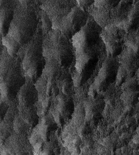
satellite image: Labrador Sea, RADARSAT-1 SAR
Did You Know?
Near-surface wind speed over the ocean can be measured from calibrated radar images. The higher the wind speed, the more roughness to the ocean surface and therefore the greater the radar backscatter.
Page details
- Date modified: