
You figure it out!
Read this first
Here are two small sections of a satellite image of the Queen Charlotte Islands, off the coast of British Columbia. We used some visible light and some infrared light information in these images, to better show vegetation. Healthy and dense vegetation is red. As the vegetation gets less dense, it is shown as pink (less red). When there is no vegetation at all, like bare earth, rock or pavement, it shows up as light blue. The deep water is very dark, almost black.
The top image shows a very small town called "Sandspit", at the edge of a forest and on the shore of the Pacific Ocean. The bottom image is of another town called "Queen Charlotte City", also on the shoreline and at the edge of the forest.
Now choose the correct answer to these questions:
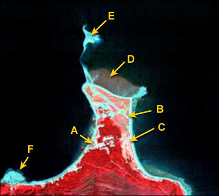
Sandspit
There are some small openings in the forest which are caused by:
- Insects destroying the forest
- Beavers cutting down the trees
- People cutting some of the forest to make room for houses and gardens
- Aliens landing their flying saucers.
There is a light blue, straight line which is:
- A scratch on the picture
- A long, skinny garden
- A short road
- An airplane landing strip
The colouring here is pink and white which means that:
- The vegetation is very sparse (thin).
- There is dense forest here.
- There are lots of pink and white buildings.
- Aliens are still landing their flying saucers.
This patch of dark, slightly red coloured area is off the shoreline, in the ocean. If red colour means vegetation, then this area must be:
- Trees that have been cut and are now floating in the ocean.
- Seaweed growing in shallow water.
- A flooded lawn
- Aliens growing an underwater garden.
This light blue feature in the ocean can't be vegetation but it's a strange shape. It must be:
- Made of sand
- Naturally, not artificially created
- A shallow-water sandbar formed by tides and current
- All of the above
There is a light blue semicircle on the shoreline. The colour and shape mean that it is:
- A sand pit
- A hill made of sand
- Deep water
- Sand outflow at the mouth of a river.
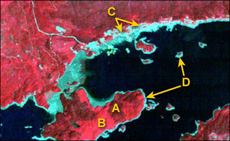
Queen Charlotte City
Two different shades of red in a forested area mean that:
- The imaging sensor on board the satellite is confused.
- There are two major types of forest here.
- One shade of red is forest, the other is sand.
- The darker shade of red is a cloud shadow.
This area of light blue covers Queen Charlotte City. It extends along the shore and has patches inland. You can see roads through the forest and a pier for docking ships. But you cannot see streets or buildings on this image because:
- The buildings are hidden in the woods.
- There are no buildings here, just tents.
- There are very few buildings and they are too small to see with this imaging sensor.
- The buildings look the same as trees.
There is a light blue fringe around each island in this image because:
- There is no forest there (red colour).
- The water is not deep (black colour).
- All the shorelines are made of sand and rock in shallow water.
- All of the above.
Page details
- Date modified: