
Contaminated Site Remediation Monitoring
H.Peter White, Canada Centre for Remote Sensing, Natural Resources Canada.

Figure 1: Monitoring mine tailings site revegetation using hyperspectral remote sensing. Study site location, Sudbury, Ontario; casi image cube of 1996; and reclamation maps showing the rehabilatation progress between 1996 and 1998. The maps were derived with spectral unmixing. Levels of abundance range from 0 in blue to 1 in red.
text version
Figure 1
This illustration is divided into three sub-sections. The first shows the location of the study site in the region of Sudbury, Ontario. The second consists of a three-dimension hyperspectral image cube produced using CASI imaging system. Surrounding this image are three graphs whose objective is to illustrate the reflectance profiles of various soil cover. Therefore, lime has a fairly uniform reflectance in the visible and infrared portion of the spectrum, while tailings have a bell-shaped reflectance distribution and, lastly, vegetation has a low reflectance in the visible portion of the spectrum but very strong in infrared.
The third section is a map showing the mine rehabilitation process, as described in the text. The use of hyperspectral imagery has identified oxidized tailings sites, vegetation sites, and sites where there is the presence of strong ground lime. Two hyperspectral images acquired in August 1996 and August 1998 were used to track the mine rehabilitation process. The purpose of the product is to show that we can track the progress of the rehabilitation of mining sites from hyperspectral imagery.
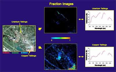
Figure 1: Monitoring mine tailings site revegetation using hyperspectral remote sensing. Study site location, Sudbury, Ontario; casi image cube of 1996; and reclamation maps showing the rehabilatation progress between 1996 and 1998. The maps were derived with spectral unmixing. Levels of abundance range from 0 in blue to 1 in red.
text version
Figure 2
This illustration focuses on the distinction of uranium and copper tailings sites and is called "fraction image". The figure is divided into three sub-products. The first shows the detailed location of the study site in Sudbury, Ontario. It locates uranium and copper tailings site residues. The analysis of hyperspectral images of each site provides the reflectance profile across the spectrum of wavelengths between 400 nanometers and 2200 nanometers. The objective of the illustration is to show that these residues have different spectral profiles and it is thus possible to separate and make a map from the proportion (fraction) of these two components in the image.
Sites contaminated with radioactive waste, mine tailings, or other material can have severe impacts on both ecosystem integrity and human health. In this regard, remediation is aimed at diminishing the interaction between the concerned site and the impacted environment. The economic impact of these sites is also of high relevance. While policies and regulations exist to manage this particular issue; every site has unique characteristics and thus requires distinctive treatment towards remediation.
Overall site management (characterization, evaluation, risk assessment, remediation, monitoring) aims to protect human health and ecosystem condition. This is, however, a complex and expensive issue, especially in remote or difficult to reach areas. There presently exists well established traditional techniques for addressing the issue (sampling in the field, lab analysis, data collection), however, these are often limited due to cost, location and extend. Remote sensing provides an opportunity to enhance and complement these analyses. It provides regional perspective to a local source influence, as well as providing a robust and quantitative approach for key issues to site managers and enforcement agents. It allows the potential for a long term economic contribution to both monitoring and mitigation issues. Like any other tool, hyperspectral remote sensing should not be used in isolation, remote sensing provides a quantitative approach to remotely monitoring and economically managing when and where risk intervention should be investigated.
Environmental monitoring of remediation management activities researched through the hyperspectral program at the Canada Centre for Remote Sensing includes the evaluation of imaging spectrometer data (hyperspectral imagery) for characterising environmentally contaminated sites and providing techniques to monitor their remediation. Examples of such sites include mine tailing sites and related waste disposal sites, and the remediation and rehabilitation of these sites.
In one example study area, hyperspectral imagery from a casi (Compact Airborne Spectrographic Imager) in the visible and near infrared was used to characterise sulphide mine tailings at the Copper Cliff tailing impoundment area in Sudbury. Other example study sites have detected and mapped the distribution of tailings from uranium mining in Canada to monitor the distribution of this potential radioactive contamination in support of site remediation.
Foundation
Environmental monitoring of remediation management activities researched at the hyperspectral program at the Canada Centre for Remote Sensing includes the evaluation of the use of imaging spectrometer data (hyperspectral imagery) for characterising environmentally contaminated sites and providing techniques to monitor their remediation. Examples of such sites include mine tailing sites and related waste disposal sites, and the remediation and rehabilitation of these sites.
Advances
In one research project advanced with collaborators INCO and the City of Greater Sudbury, hyperspectral imagery from a casi (Compact Airborne Spectrographic Imager), and Hyperion (aboard EO-1) in the visible and near infrared was used to characterise sulphide mine tailings at the Copper Cliff tailing impoundment area in Sudbury. This site was chosen primarily to monitor the results of re-vegetation efforts performed in the impacted region. Image data sets of the study sites were processed and analyzed using the CCRS ISDAS (Imaging Spectrometer Data Analysis System). Results displayed here indicate that these techniques can be employed successfully to map such sites and to monitor the results of rehabilitation efforts.
More recently, a CCRS representative involved in Imaging Spectrometry Science has been invited to consult with the International Atomic Energy Agency (IAEA) to produce a guidance document on the use of remote sensing technologies in the assessment of remediation works of radioactive waste contaminated sites. This guidance document once developed will be released to all member states (including Canada) to assist remediation management and reporting of progress.
References
Richter, N.; Staenz, K.; Kaufmann, H. Spectral unmixing of airborne hyperspectral data for baseline mapping of mine tailings areas. International Journal of Remote Sensing 29 (13) 2008
Shang, J.; Neville, R.; Staenz, K.; Sun, L.; Morris, B.; Howarth, P. Comparison of fully constrained and weakly constrained unmixing through mine-tailing composition mapping. Canadian Journal of Remote Sensing 34(1) 2008
Page details
- Date modified: