
Northwest Territories’ Shale and Tight Resources
Northwest Territories

A product of the Energy and Mines Ministers’ Conference
Northwest Territories’ Oil and Gas Resources

- 16.4 TRILLION CUBIC FEET
Discovered, Technically Recoverable Conventional Natural Gas- 10.2 TRILLION CUBIC FEET
Onshore - 6.2 TRILLION CUBIC FEET
Offshore
- 10.2 TRILLION CUBIC FEET
- 1,227.8 MILLION BARRELS
Discovered, Technically Recoverable Conventional Crude Oil- 561 MILLION BARRELS
Onshore - 667.4 MILLION BARRELS
Offshore
- 561 MILLION BARRELS

- 0.01 BILLION CUBIC FEET/DAY
Total Natural Gas Production (2013)- 0 BILLION CUBIC FEET/DAY
Shale/Tight Gas Production (2013)
- 0 BILLION CUBIC FEET/DAY

- 0.01 MILLION BARRELS/DAY
Total Crude Oil Production (2013)- 0 MILLION BARRELS/DAY
Tight Oil Production (2013)
- 0 MILLION BARRELS/DAY
Source:
- Resource estimates: Government of the Northwest Territories
- Production estimates: National Energy Board (may not align with provincial data due to differences in methodology)
Geography
The Mackenzie Plain occupies the western part of the mainland of the Northwest Territories and includes the town of Norman Wells (Figure 1). The Mackenzie Plain covers 18,300 square kilometres in aerial extent. It is a flat, generally poorly drained plain that extends for 80 to 160 kilometres (50 to 100 miles) on both sides of the Mackenzie River. The river is deeply entrenched in the glacial sands and gravels of the lowland, and it flows between generally high steep banks. Above the valley plain are a few higher hills that are erosional remnants of harder rocks. One of these remnants is the Horn Mountains, north of the Mackenzie and west of Great Slave Lake. The folded Franklin Mountains rise to 1,220-metre linear ridges above the lowland and east of the Mackenzie. They are cut into two sections by the Great Bear River. The high barren ridges of the Mackenzie Mountains rise abruptly to the west of the lowland. Located in the Mackenzie range are the highest points in the Northwest Territories, including an unnamed peak rising to 2,773 metres and Mount Sir James MacBrien at 2,762 metres, the second highest peak. Several rivers cut into these mountains and form passes leading westward into the Yukon Territory.
Liard Basin
The Liard Basin area covers 8,400 square kilometres in the Northwest Territories portion of the basin and is a total of 37,500 square kilometres with the inclusion of the Yukon Territory and the province of British Columbia. It is located in the south-western corner of the Northwest Territories, straddling borders with the Yukon Territory and the province of British Columbia (Figure 1). It is traversed by the Liard River and defines a relatively high plateau between the Selwyn Mountains and the northern Rocky Mountains. Along the Liard River, wetlands are found within flat vegetated areas and landscape depressions from glaciers that were created 9,000‒12,000 years ago. Permafrost covers a significant portion of the lowlands and wetlands. Vegetation varies from the Boreal forest to the Arctic and Alpine tundra.
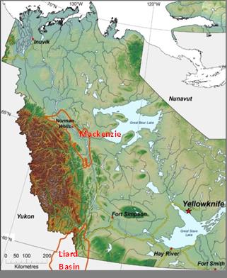
Figure 1: Mackenzie Plain and Liard Basin
Source: Northwest Territories Geological Survey (NTGS)
Text version
Figure 1: Mackenzie Plain and Liard Basin
Map of the Mackenzie Plain and the Liard Basin
Geology
Northwest Territories shales with known unconventional resource potential include the Givetian- to Frasnian-aged Horn River Group shales (Figure 2) of the Central Mackenzie Valley (CMV) and Liard Basin (Figure 1).
Liard Basin Central Mackenzie Valley
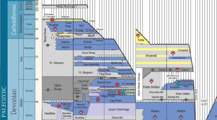
Figure 2: NT Devonian to Early Carboniferous stratigraphy
Source: Northwest Territories Geological Survey (NTGS)
Text version
Figure 2: NT Devonian to Early Carboniferous stratigraphy
Stratigraphy of the Devonian to Early Carboniferous strata in the Liard Basin and the Central Mackenzie Valley.
CMV
The CMV, also known as the Mackenzie Plain area, is the focus of recent land sale and drilling activity associated with the Canol Formation unconventional oil play. The results of detailed geological studies recently completed by the Northwest Territories Geological Survey (NTGS) show that the Canol and Bluefish Formations are characterized by high kerogen and silica contents and low clay abundances. Kerogen thermal maturities show that the Canol and Bluefish shales have been heated to temperatures within the oil to wet gas generation window (4400 to 4650 degrees Celsius – see Table 1).
| Formation or Member |
Thickness (metres) |
Silica Content Range High 80%> Low 20%< |
Clay Content Range High 80% > Low 20% < |
TOC % Range Content |
Burial Depth Range (metres) |
*Maximum Temperature Degrees Celsius |
|---|---|---|---|---|---|---|
| Canol | 70 | High | Low | 5‒20 | 1500‒2500 | 440‒465 |
| Bluefish | 40 | High | Low | 2‒17 | 1600‒2600 | 445‒465 |
*The maximum temperatures measured from 440‒465 degrees Celsius calculate the maturity of these hydrocarbons to generate hydrocarbons in the oil and wet gas windows.
In June 2015, the National Energy Board and the NTGS released a joint energy briefing note entitled An Assessment of the Unconventional Petroleum Resources of the Bluefish Shale and the Canol Shale in the Northwest Territories, the first publicly released study examining the unconventional oil-in-place resources for the Bluefish Shale and Canol Shale basins, both located in the Mackenzie Plain. The National Energy Board indicated that the unconventional oil-in-place reserves median estimate stood at 191 billion barrels of oil in the Canol and Bluefish shale basins.
| billion cubic metres (billion barrels) | Oil In-Place | ||
|---|---|---|---|
| Low | Expected | High | |
| Bluefish | 4.392 (27.634) |
7.366 (46.346) |
11.254 (70.808) |
| Canol | 13.129 (82.605) |
23.018 (144.825) |
35.095 (220.811) |
Source: National Energy Board (2015)
Liard Basin
Industry drilling activity south of the Northwest Territories border within Alberta and British Columbia have demonstrated the potential for shale gas plays associated with Klua, Evie, Otter Park and Muskwa Formation shales of the Horn River Group and the lower Carboniferous-aged Exshaw Formation shale. Successful drilling activities for these plays are focused in the Liard, Horn River and Cordova Basins. These dry-gas-prone shale formations are present in the extension of the basins into the Northwest Territories. The NTGS is currently engaged in a tri-jurisdictional geological assessment of the hydrocarbon potential of the Devonian- to Carboniferous-aged shales in the Liard Basin area. The study was initiated in 2012, includes detailed source rock studies (surface and subsurface) of the Horn River and Besa River shales, and will continue until approximately 2016. The geological surveys of the Northwest Territories, Yukon Territories and British Columbia (BC Oil and Gas Commission) are engaged in a resource assessment of the Horn River Group shales with the National Energy Board and a publication for this assessment was released in May 2015. The National Energy Board has concluded the Liard basin resource assessment and publicly released the results as an energy briefing note in March 2016.
| Shale | Play Area | Dry Gas in Place (TCF) | Marketable Gas (TCF) | ||||
|---|---|---|---|---|---|---|---|
| Low | Expected | High | Low | Expected | High | ||
| Upper Besa River/Exshaw | British Columbia (BC) | 497 | 848 | 1337 | 65 | 167 | 323 |
| Yukon | 27 | 47 | 73 | 3 | 8 | 14 | |
| Northwest Territories | 184 | 318 | 514 | 18 | 44 | 88 | |
| Total | 708 | 1213 | 1924 | 86 | 219 | 425 | |
Note: Low, expected and high estimates take into account various uncertainties associated with the data used to evaluate the resource. TCF is an abbreviation for trillion cubic feet.
Source: National Energy Board (2016)
|
Table 4: Lower Besa River/Horn River Gas In Place and Marketable Gas volumes for the Liard Basin, Northwest Territories and Yukon |
|||||||
| Shale | Play Area | Dry Gas in Place (TCF) | Marketable Gas (TCF) | ||||
|---|---|---|---|---|---|---|---|
| Low | Expected | High | Low | Expected | High | ||
| Lower Besa River/Horn River | Yukon | 11 | 21 | 36 | - | - | - |
| Northwest Territories | 91 | 187 | 317 | - | 33 (estimate) |
- | |
Note: TCF is an abbreviation for trillion cubic feet.
Source: National Energy Board (2016)
The National Energy Board did not attempt to estimate the Lower Besa River /Horn River marketable gas volumes in the Northwest Territories and Yukon. However, it is reasonable to assume that the recovery factor will be similar to that evaluated for Horn River shale marketable gas volumes in the Horn River Basin of British Columbia (17.4 percent). Application of this recovery factor to the Lower Besa River /Horn River expected gas in place yields expected marketable gas volumes of 33 trillion cubic feet for the Northwest Territories.
The expected marketable gas volume for the two shale packages in the Northwest Territories is estimated to total 77 trillion cubic feet. This is a sizeable unconventional marketable gas volume that is equivalent to the expected marketable gas volume of 78 trillion cubic feet for Horn River Group shales (Muskwa Formation and Otter Park and Evie Members) in northeastern British Columbia. In other words, the data suggest a world-class unconventional gas play.
Exploration and Production
CMV
Exploration activity has been focused on the Canol and Bluefish shale oil play. Three successive calls for bids from 2011 to 2013 have resulted in the acquisition of 14 exploration licenses (ELs) by six companies for a total of 627.5 million dollars in work commitments. Successful bidders include Husky Oil Operations Limited, Shell Canada Limited, Imperial Oil Resources Ventures Limited, MGM Energy Corp., ConocoPhillips Canada Resources Corp., and International Frontier Resources Corporation. Thus far, seven wells were drilled in the past four and a half years: two wells by Husky Oil Operations Ltd. 12, one well by MGM and its partners, and four wells by ConocoPhillips Canada Resources Corp. . There is currently no reported production for this unconventional resource play.
Liard Basin
Lone Pine Resources Canada Ltd. is the only operator that has tested hydrocarbons from the Horn River shales in the Northwest Territories portion of the Liard Basin. In 2011, they recompleted an existing vertical wellbore (L-68) and, according to their press release, acquired sweet gas flow rate data that supports the potential deliverability of 12 million cubic feet per day from a potential multi-fractured horizontal completion. In May 2013, the National Energy Board granted Lone Pine Resources Canada Ltd. a commercial discovery declaration for natural gas resources contained in the Upper and Lower Besa River shale intervals associated with the L-68 well. Lone Pine also acquired a 21-year lease extension on approximately 53,000 acres until 2034 from the Minister of Aboriginal Affairs and Northern Development in accordance with section 62 of the Canada Oil and Gas Lease Regulations. There is currently no unconventional resource production for this region.
Regulation
Regulatory Changes and Devolution in the Northwest Territories
On April 1, 2014, through the process of devolution, the Government of Northwest Territories’ (GNWT) Department of Industry, Tourism and Investment (ITI) became responsible for the administration of onshore oil and gas interests in the Northwest Territories. Interests issued in the offshore remain Aboriginal Affairs and Northern Development Canada’s (AANDC) responsibility.
The GNWT became the regulator for the Northwest Territories’ onshore petroleum interests, outside of the Inuvialuit Settlement Region (ISR). The Office of the Oil and Gas Operations is primarily responsible for granting petroleum authorizations for this area.
Granting authorizations for oil and gas works and activities in the Northwest Territories was previously the responsibility the National Energy Board.
The National Energy Board will remain the regulator of oil and gas activities in the ISR, under GNWT legislation and regulations, and in the offshore and excluded sites, under AANDC jurisdiction in Norman Wells Proven Area.
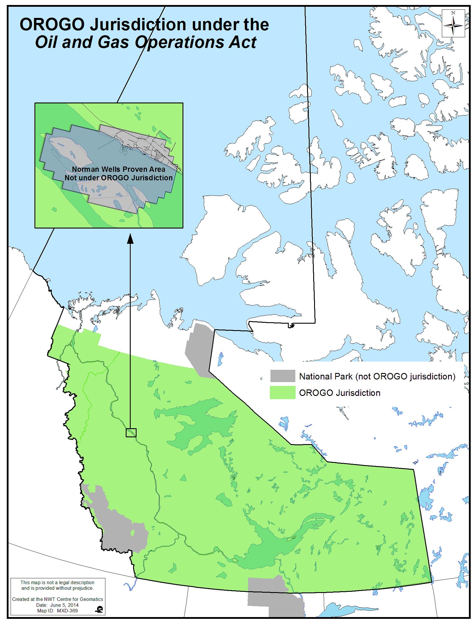
Figure 3: Jurisdiction of the GNWT Regulator of Oil and Gas Operations
Source: Office of the Regulator of Oil and Gas Operations (OROGO)
Text version
Figure 3: Office of the Regulator of Oil and Gas Operations (OROGO)
Map highlighting the regions of the Northwest Territories under the jurisdiction of the Government of the Northwest Territories’ Office of the Regulator of Oil and Gas Operations.
Due to the differences in onshore petroleum regulators based on jurisdiction, there are two versions each of five regulatory processes (National Energy Board leads in the ISR; OROGO leads in the rest of the Northwest Territories).
The Petroleum Resources Act (PRA) is mirror legislation of the Canada Petroleum Resources Act. The PRA applies to petroleum lands, which are lands under the administration and control of the Commissioner. It sets out rules regarding issuance of interests, exploration licences, significant discovery licences, production licences, and royalties.
The Oil and Gas Operations Act (OGOA) is mirror legislation of the Canada Oil and Gas Operations Act. OGOA sets out rules regarding the issuance of authorizations and approvals for oil and gas works and activities.
Please visit the Office of the Regulator of Oil and Gas Operations (OROGO) website.
Please visit the GNWT Petroleum website:
Public Research
Energy and Mines Ministers’ Conference
Northwest Territories
Page details
- Date modified: