
ARCHIVED - Sensitivities, Impacts and Adaptation
Information Archived on the Web
Information identified as archived on the Web is for reference, research or recordkeeping purposes. It has not been altered or updated after the date of archiving. Web pages that are archived on the Web are not subject to the Government of Canada Web Standards. As per the Communications Policy of the Government of Canada, you can request alternate formats. Please "contact us" to request a format other than those available.
The key concepts presented in Chapter 2 provide the foundation for understanding the following description of the sensitivities, vulnerabilities, opportunities, anticipated impacts and possible adaptation strategies, both spontaneous and planned, for Quebec.
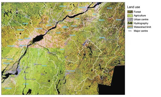
The approach used here is not only regional in focus (north, central, maritime and south subregions), but also sectoral and cross-sectoral (see Section 3.5), in order to integrate issues not addressed in the sections dealing with the subregions. As indicated in the Ouranos (2004) report, the boundaries of these four subregions must not be perceived as administrative boundaries, but rather as gradual transition between zones that share similar characteristics.
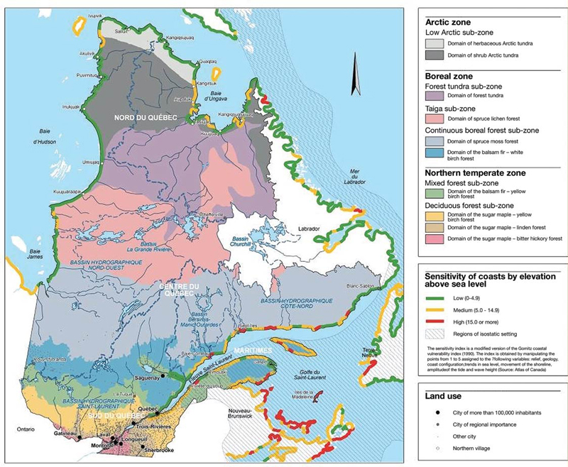
Figure 12, which should be referred to constantly throughout this section, synthesizes several key characteristics pertaining to Quebec, which can be summarized as follows:
- the north subregion (see Section 3.1) is characterized by the presence of a few isolated communities experiencing significant socioeconomic and demographic changes.
- the central subregion (see Section 3.2) is characterized by extensive natural resources that are important for the local and overall Quebec economy.
- the maritime subregion (see Section 3.3) is characterized by development along coastal areas.
- the south subregion (see Section 3.4) is the locus of steady urbanization and contains the majority of the population, economic activity and infrastructure, all of which create growing pressure on the environment.
3.1. NORTH SUBREGION
Nunavik differs from other Quebec regions due to its sparse plant and animal life, a long cold season and a landscape dominated by snow and ice. The way of life of its mainly Inuit population is closely tied to the environment. The Inuit live in 14 villages (Figure 12) where infrastructure is concentrated. Their society is coping with important generational changes and undergoing rapid demographic growth and a transformation of socioeconomic activity formerly based on traditional ways of life. Despite these profound changes, certain activities (food supply, fur sales on international markets) still account for an important share of the local economy. Figure 8 and Table 1 suggest that Nunavik will experience, along with many other diverse changes, the greatest climate change in Quebec in absolute value, mainly due to the climate feedback effect of snow and ice and the presence of Hudson Bay to the west. The results and conclusions of initiatives such as the Arctic Climate Impact Assessment (Arctic Climate Impact Assessment, 2004), ArcticNet (2006), the Canadian Climate Impacts and Adaptation Research Network (Canadian Climate Impacts and Adaptation Research Network, 2006) and the Ouranos projects, apply to this region north of the 55th parallel known as 'Arctic Quebec'.
Changes to the natural environment
Along with recent climate change, the temperature of the permafrost rose an average of 1 to 1.5 °C to a depth reaching 20 m at some study sites in Nunavik between 1990 and 2002, accompanied by a noticeable deepening of the active layer, the surface layer that thaws in summer (Allard et al., 2002a). The Inuit report significant environmental changes and even experienced hunters say they have difficulty predicting weather, snow and sea conditions in their travels by snowmobile or canoe (Tremblay et al., 2006). Traditional Inuit knowledge seems less reliable and many accidents, sometimes involving experienced individuals, are reported (Nickels et al., 2005).
Heat transfer in the soil following climate warming will inevitably cause partial or total thawing of the permafrost, depending on the real extent of warming during the twenty-first century (Lawrence and Slater, 2005). Consequently, ecosystems will be greatly disturbed by permafrost degradation, which is already causing subsidence of the land and creating and expanding small thermokarst lakes (Seguin and Allard, 1984). Drainage networks on sensitive soils are likely to be modified by the drying and the extension of peat bogs and wetlands (depending on local topography and soil texture), as well as by gullying and rill erosion (Payette et al., 2004). Stimulated by milder summers and greater snow cover protection on the tundra in winter, the expansion of shrub populations would transform ecosystems significantly, increasing their primary productivity, which should have repercussions on the animal kingdom. The distribution of animal species is bound to move northward in keeping with these changes. It remains to be determined how this will affect the behaviour of such migratory populations as caribou herds, Arctic char, geese and ducks, seals and whales. Ecosystems that adapt spontaneously are discussed at the provincial scale in Section 3.5.
To the extent that precipitation, evapotranspiration and subsurface flow are affected, the hydrological regime of the rivers will change and water temperatures will rise. Sediment inflow may result from permafrost degradation, although its scope remains to be assessed. All these changes will have a significant effect on regional aquatic wildlife.
Sensitive infrastructure
The risk posed by permafrost degradation varies from community to community depending on geomorphology (rock outcrops, granular or clayey soils containing ice, instability factor when thawing). From the tree line to the shores of Hudson Strait, the climatic gradient is such that the discontinuous permafrost, having temperatures near the freezing point, becomes colder as one moves farther north. Consequently, a fairly uniform regional warming would act first on the southern fringes of the permafrost and then gradually on more northerly areas. Up to now, municipal planning has taken into account the nature of the terrain in each community as much as possible. Moreover, most institutional buildings, such as schools and hospitals, and most houses are built on piles or trestles, which allow air circulation and keep the soil at or near air temperature (Fortier and Allard, 2003a, b).
However, important buildings and infrastructure (airports, roads) are partially or totally built on sensitive terrain. In areas where the soil consists of unconsolidated deposits containing ice, permafrost thawing causes soil subsidence and buckling that can damage infrastructure. This is the case for airport infrastructure in 13 of the 14 villages. There is concern for the safety and integrity of these airports (Grondin and Guimond, 2005), which fall under the responsibility of the Quebec Ministère des Transports (MTQ). In fact, permafrost thawing has already caused subsidence, cracks and signs of deterioration on several airport runways and on roads connecting them to the villages (Beaulac and Doré, 2005). Existing maintenance measures have so far been enough to ensure safety. However, the frequency and rising cost of repairs, observed damage and increased maintenance activity have prompted the MTQ and Ouranos to draw up a research program to characterize the permafrost beneath and at the edge of infrastructure (thermal profile, subsidence, climate conditions) to assess the behaviour of this infrastructure since its construction, to predict its evolution and, finally, to develop adaptation measures (Beaulac and Doré, 2005; Ministère des Transports du Québec, 2006a).
Local transportation and access to resources
In Nunavik, the hunters and gatherers travel mainly by boat in summer and snowmobile in winter. The types of roads used (waterways and ice roads) are important for food supply (hunting, fishing, berry picking, egg gathering), moving goods and people between communities, and accessing sites for traditional pursuits, such as trapping, gathering or family and social activities. Travel and access to resources are critical both to acquire food and to preserve the social cohesion essential to maintaining a culture already weakened by other stresses (Lafortune et al., 2005). Climate impacts (difficult weather forecasting, late freeze-up and early melting of the ice) make travel more risky, and thus affect socioeconomic and cultural aspects as much as the transfer of traditional knowledge, and have repercussions on individual and collective identity in this changing society (Tremblay et al., 2006).
Growing economic activity
Resource development is growing in Nunavik. Mining activity is increasing rapidly as the area becomes more accessible and with the help of international metals markets. Climate change offers new development opportunities, such as the reduced cost of ore shipping made possible by waterways that remain ice-free for longer periods (Beaulieu and Allard, 2003). On the other hand, this new access will put additional pressure on species that depend on the ice cover, and on populations that depend on these species for their subsistence. Moreover, climate change makes it uncertain whether toxic mine tailings will freeze during mine operation and after the deposits have been depleted. The effect of this uncertainty on future production is higher-than-expected cost estimates during and after mine operation to prevent any contamination of the natural environment by the seepage or flow of toxic material.
If harnessing the rivers of Ungava Bay to generate electricity were ever to become acceptable from a business and social viewpoint, the promoter would have to manage uncertainties related to the hydrological regime due to a climate that is changed but probably more beneficial because of the expected increase in precipitation. In addition, the high wind potential of the subregion (Environment Canada, 2007a) would promote the development of wind energy as a complement to electricity production by diesel power stations in several communities, thereby achieving diversity of supply while reducing dependence on costly fossil fuels, which are transported by boat. Even by contributing in a small way to reducing GHG emissions, wind production would present a strong political argument, since the Inuit would help to reduce GHG emissions by greatly reducing their use of fossil fuels.
Adaptation strategies
Recent knowledge regarding permafrost located beneath infrastructure and the application of civil engineering practices and solutions will help manage the impacts of climate change on airports, roads and buildings (Allard et al., 2002b). To strengthen and maintain the integrity of infrastructure built on permafrost, various solutions are being tested or have already shown their effectiveness. For example, heat penetration into backfill can be countered by air convection and the use of insulation techniques and reflective surfaces; otherwise, the heat can be extracted from backfill using drains. Installing geotextiles, or even strengthening and raising infrastructure at risk, can also help diminish vulnerability (Beaulac and Doré, 2005).
Large-scale mapping of permafrost conditions in each village is a tool to improve municipal planning aimed at adaptation to climate change in the long term. In any event, building standards and decision-making must henceforth take climate change into account (Allard et al., 2004) to prevent an increase in vulnerability.
Access to the land for traditional pursuits receives special attention from local authorities such as the Kativik Regional Government in terms of ensuring safety along land routes (ice roads) or on navigable waterways (Bégin, 2006). In collaboration with local communities, a study is underway to determine how to better anticipate and better adapt to the new winter ice and snow conditions by relying on a network of northern weather stations (Lafortune et al., 2005). The small number of weather stations and the poor quality of chronological data series currently make it difficult to validate the models used, but this difficulty should be reduced with the establishment of new weather stations by Environment Canada.
At a workshop on the status of regional projects, held in Montréal on October 6, 2005, education and the development of awareness and information tools were identified as important ways to reduce the vulnerability of infrastructure to climate change. Officials from the Kativik Regional Government also emphasized the need to improve weather data and the ability to predict extreme events, such as blizzards, storms, gales, sudden thaws and fog. Concerns raised by the Inuit included their need for a better analysis of the impact of climate change on ecosystems and wildlife. Current studies focus on defining adaptation methods that resolve built environment or municipal planning problems. To a lesser extent, they also seek to better understand the most important changes affecting resources and the traditional pursuits of hunting, fishing and gathering.
In summary, strong regional population growth, the resulting urban development, and changes in access to resources and the traditional pursuits of hunting, fishing and gathering are responsible for bringing on difficult and multifaceted socioeconomic change. Accelerated thawing of the permafrost and pronounced climate change are raising the stakes and increasing the pace of change.
CASE STUDY 1: From impact to adaptation: case study of Salluit
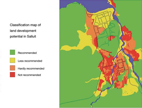
To lessen the impact of accelerated permafrost degradation at Salluit and reduce the consequences on infrastructure, the Centre d'études nordiques (Nordic Studies Centre) and Ouranos are developing a geological and geothermal model that integrates all factors that could affect soil stability. The part of the study already completed provides maps (Figure 13) on which information layers identify sensitive soils and make it possible to optimize land-use planning that takes the impact of climate change into consideration (Allard et al., 2004). In communities as a whole, current planning practices, including urban drainage maintenance, snow removal methods, layout of new streets and design of foundations, should be revised to limit the impact of climate change on the land. Certain recent decisions should perhaps be reviewed, one example being the paving of streets, which can increase heat transfer into the permafrost and therefore constitutes a maladaptation. Various civil engineering- related adaptation methods, such as convection in backfill, heat drains and reflective surfaces, will be tested in Salluit as part of a project to assess their cost effectiveness given conditions prevailing in the study areas (Doré and Beaulac, 2005).
3.2. CENTRAL SUBREGION
The environment in the central subregion is characterized by boreal forest and numerous lakes, rivers and reservoirs (Figure 12).Whereas the cold season is dominant in the north subregion and the warm season is dominant in the south subregion, the two seasons are closer in length in the central subregion. Snowfall is generally much more abundant in the east due to numerous winter storms arriving from the east coast of the United States. Population density is low and declining, and local economies often depend on a single industry, yet primary sector economic activity from natural resource (water and forest) exploitation stimulates the strength of Quebec's economy as a whole. Ouranos (2004) calls this subregion a 'resource region' and, for this reason, the sensitivity of forests and water resources to climate change is addressed here.
3.2.1. Forests
Since the last glaciation, Quebec forests have evolved under a harsh climate combined with dynamic natural disturbances, which have led to the formation, from south to north, of large forest ecozones of maple, balsam fir and spruce. Significant climate warming over the last century has already resulted in a change in equilibrium between the climate and forest composition (Forget and Drever, 2003). Anticipated warming will further accelerate the rupture of this equilibrium and result in changes in the composition and productivity of forest stands. The dynamics of natural disturbances (fire and insects) and the frequency of extreme weather events (droughts and freezing rain) are also bound to change.
Growth and productivity
A rise in temperature can act directly on physiology and metabolism and can also lengthen the growing season. Signs of a lengthening of the growing season are already visible. Bernier and Houle (2006) estimated that the budbreak date of the sugar maple has occurred earlier by several days in the past 100 years, and Colombo (1998) reported similar results for the white spruce. In Alberta, the blossoming date of the aspen poplar has advanced by 26 days in the past 100 years (Beaubien and Freeland, 2000). In Europe, the growing season of several plant species has lengthened by 11 days since just 1960 (Menzel and Fabian, 1999).
The preliminary results of growth prediction models based on a 2 x CO2 scenario suggest an increase in net primary productivity for forests in eastern Canada, while forests in the west would be affected in the opposite manner (Price and Scott, 2006). However, most models are based on climate-growth relations of diverse species and do not consider factors that are potentially negative for productivity. The rather positive picture in Quebec must be considered as an optimistic scenario from which potential losses must be subtracted. For example, the emergence of exotic species or more frequent drought conditions could cancel out any gains (Kirschbaum, 2000; Johnston andWilliamson, 2005).
A rise in atmospheric concentration of CO2 would have a fertilizing effect on forests, leading to an increase in net primary productivity (Ainsworth and Long, 2005: Price and Scott, 2006). Greater productivity has already been observed in the upper and middle latitudes between 1980 and 1999 (Nemani et al., 2003), for black spruce at the northern limit of its distribution range since the 1970s (Gamache and Payette, 2004) and for poplar, whose average biomass increased by up to 33% (Gielen and Ceulemans, 2001). However, some studies suggest that the gains would be either cancelled by an acclimatization to the new CO2 levels after a few years (Gitay et al., 2001) or limited by nutrients (Drake et al., 1997) and other factors (Kirschbaum, 2000; Johnston and Williamson, 2005).
Migration
Analyses of various biotic communities based on a 2 x CO2 scenario suggest significant movements from geographic areas in both latitude and altitude, as was observed in the Rockies in response to the 1.5 °C increase in mean temperature during the past 100 years (Luckman and Kavanagh, 2000). The migration should nevertheless take several centuries, since the dispersal capacity remains limited. For example, the anticipated rise in annual mean temperature of 3.2 °C by 2050 for the central subregion (see Table 2) would cause climate zones to move 515 km northward at the rate of 10 km/year for forests - a speed clearly higher than the fastest observed migration speed of trees (500 m/year). The migration would probably not take place by groups of species, since dispersal speeds and physiological responses vary by species, as much for black spruce and jack pine (Brooks et al., 1998) as for mixed forest (Goldblum and Rigg, 2005). Finally, soil fertility would limit the movement of trees, since the nutrient requirements of the forest vary by stands (maple < balsam fir > spruce forest; Houle, pers. comm., 2006).
Disturbances
Natural disturbances play an important role in shaping the forest landscape. They affect ecosystem composition, structure and processes. These disturbances include insect epidemics, forest fires, disease and extreme weather conditions such as drought, ice storms and violent winds. A change in climate conditions will influence the severity, frequency and extent of these disturbances.
The short life cycle and ease of movement of insects would allow them to become established at higher latitudes with the help of milder winters, although the reduction in snow cover thickness could shrink the distribution range of certain species (Ayres and Lombardero, 2000). However, it is difficult to predict the reaction of a given insect due to differences between species with respect to seasonality, thermal reactions, mobility and host plants (Logan et al., 2003). Based on landscape-level models, R égnière et al. (2006) suggested that the range of the spruce budworm (Choristoneura fumiferana [Clem.]) would increase significantly, and Quebec would experience a southward extension of the gypsy moth (Lymantria dispar [L.]), a spread of the mountain pine beetle (Dendroctonus ponderosae [Hopk]) from west to east in the boreal forest, and the establishment of the Asian long-horned beetle (Anoplophora glabripennis [Motchulsky]) on maples, elms and poplars (Cavey et al., 1998; Peterson and Scachetti-Pereira, 2004). In addition, trade globalization and reduced merchandise transit times favour the introduction and establishment of new exotic species (Ayres and Lombardero, 2000).
There is some uncertainty regarding the future frequency of forest fires. Although most climate models predict an increase in fires for the northern hemisphere due to the lengthening of the growing season and the increased occurrence of lightning (Wotton and Flannigan, 1993), the situation could be more variable in Quebec because of more abundant rainfall (Flannigan et al., 2001). Thus, fire frequency could increase in the west and north, diminish in the east and remain constant in the centre (Bergeron et al., 2004). Under a 3 x CO2 scenario, Flannigan et al. (2005) estimated that the burned area would increase by 74% to 118%. The differences between these studies arise from the lower reliability of regional predictions related to large ecozones and the fact that potential interactions with other disturbances (insect epidemics) are not considered. Considerable uncertainty also remains with respect to the frequency, scope and intensity of extreme events (violent winds, hurricanes, ice storms) affecting deciduous forests (Cohen and Miller, 2001; Hooper et al., 2001).
A reduction in the duration of winter has direct and immediate impacts on forestry activity and its planning, specifically a reduced period of site access (winter roads) and a marked change in the seasonality of employment. This type of direct impact is of interest to forestry companies because reduced thickness, discontinuity or early melting of the snow cover have become preoccupying issues where forests in the south subregion are concerned. The ground exposed to ambient air is subject to freezing, causing significant damage to tree roots and affecting growth (Boutin and Robitaille, 1995).
Adaptation strategies
There are various aspects to adaptation mechanisms. For example, adaptation to the anticipated effects of climate change can be considered from an operational standpoint or a strategic planning perspective. They could range from very concrete strategies regarding the condition of forest roads and modifications to machinery, particularly in areas dependent on winter operations, to more global considerations, such as taking the anticipated effects of climate change into account when undertaking forest management strategic planning. By integrating climate scenarios and knowledge on the fertility and characteristics of forest soils at the planning stage, forest management could promote adaptation to climate change.
A number of adaptation options appear to be feasible, such as the use of reforestation with seedlings that are more adapted to the new climate conditions, even though only 15% of harvested areas are currently reforested. However, this solution would require the availability of accurate regional climate predictions.
In the case of forest fires, there already exists a set of adaptation measures, including increased surveillance, an effective warning system and an improvement in salvage cutting (Wotton et al., 2003). If the number of forest fires were to increase significantly, it is possible that these adaptations would not be enough to reduce the impact of climate change on the fire regime.
Because of the large area covered by forests in Quebec, adaptation measures on a large scale are difficult to apply. In addition, uncertainty surrounding the potential impacts of climate change on the forest in general, and more specifically at the regional scale, limit the implementation of specific measures in the short term.
In summary, climate change will increase the growing period and the northward migration of vegetation zones. The frequency and intensity of natural disturbances, such as the spread of pathogens and insect pests, would increase along with extreme climate conditions. Given the importance of the forest industry in Quebec, adaptation strategies aimed at reducing these impacts are few in number and would be implemented on a case-by-case basis, based on the biophysical and socioeconomic characteristics of the subregions.
3.2.2. Hydroelectricity production
The energy sector holds a predominant place in the Quebec economy. Electricity comes mainly from hydroelectric generating stations (96%), a few thermal generating stations (oil, natural gas or biomass) and one nuclear plant, Gentilly-2. Some 80% of the installed capacity of 42 950 megawatts (Minist ère des Richesses naturelles et de la Faune du Québec, 2006c) is located north of the 49th parallel and three large hydroelectric complexes (Bersimis -Manic-Outardes, La Grande and Churchill Falls) draw upon vast reservoirs (Institut national de recherche sur les eaux, 2004) to satisfy the bulk of Quebec demand. In the north, storage power stations represent 95% of installed capacity, whereas run-of-river power stations account for 95% of installed capacity in the south. For this reason, the anticipated impacts of climate change on these two types of power stations are considered separately. It is also important to clarify that changes in the hydrological regime depend both on changes in precipitation and variations in temperature. The latter are likely to affect evapotranspiration in watersheds and therefore have a significant impact on the hydrological cycle (Guillemette et al., 1999; Allen and Ingram, 2002).
In the northern part of the central subregion, all climate models forecast warmer temperatures and more abundant precipitation. The following considerations were drawn up according to regional climate scenarios, but they must be treated with caution given the level of uncertainty.
A modified thermal regime would result in reduced precipitation in solid form and snow cover. It would also cause an increase in evapotranspiration rates during the open water period, which would nevertheless be offset by an important increase in general precipitation, resulting in higher reservoir levels.
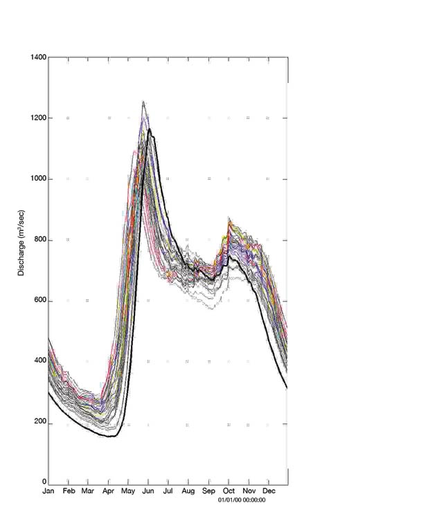
The anticipated hydrograph (Figure 14) was produced by feeding a hydrological model with observed climate data that were altered based on the differences in temperature and precipitation, as suggested by different climate scenarios generated by global climate models. It can be deduced from this figure that future natural inflow would be more sustained in winter (from November to April), that the spring flood would occur two to three weeks earlier, that the flood volume would probably be reduced and that summer inflow would probably be less important due to a significant increase in evapotranspiration. Adjustments in annual reservoir management practices must be expected, since reservoirs would be fed later in early winter by more precipitation in liquid form, while floods would occur earlier and be less significant. The new climate would have a greater natural regulating effect on an annual basis, a conclusion consistent with those reached by Slivitzky et al. (2004) using the first versions of the CRCM.
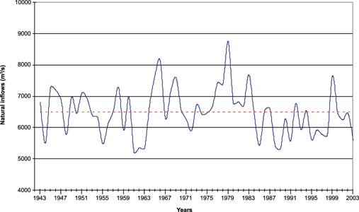
Since the historic annual inflow series (Figure 15) shows no statistical change in average, cycle or trend, it was agreed by Hydro-Qu ébec for purposes of planning future production equipment that the mean value of inflow over the historical period would be observed over the coming years. However, available climate scenarios show a rising trend in mean annual inflow values over a 50-year period, together with larger year-to-year variations for the subregion, thereby casting doubt on the assumption of a stationary climate.
Furthermore, the periods during which temperatures fluctuate around 0°C would occur more frequently. These are periods of the year when reservoirs are filled to a high level. Indeed, high heating demand in winter requires reservoirs to be full at the start of winter to ensure sustained electricity production throughout the cold season. It is precisely at this time of the year that temperatures fluctuating around 0 °C would either limit inflow (precipitation in the form of snow), or increase it if the precipitation was in liquid form and flowed on ground that was frozen or covered with a thin layer of snow. These particular conditions would require a change in current reservoir filling strategies to limit the risk of non-productive spillovers and their considerable financial consequences (Forget, 2007). However, if these rainfall events were to occur during mild spells later in the winter, when the snow cover is thicker, the rain would be absorbed by the snow and the impact on flow would be limited, all the more since reservoir levels would be somewhat lower due to intensive electricity production at that time of the year.
Despite the low certainty level, the frequency of extreme events associated with the water cycle is expected to increase. A higher frequency of intense storms, which produce heavy precipitation over a short period of time, would require that special attention be paid to affected facilities and more frequent non-productive spillovers. Aside from the economic consequences of such situations, at least the security of structures and populations would not be threatened. In contrast, greater vigilance must be shown in southern Quebec, where a dense population lives in proximity to dams and run-of-river generating stations. This requires better knowledge regarding the frequency and magnitude of possible extreme events to guide design work for new facilities, as existing facilities were designed to meet safety criteria related to past extreme events.
Adaptation strategies
In Quebec, lack of knowledge of future hydrological events is an issue of concern for water resource managers, and the related economic stakes are high (Hydro-Québec, 2006). However, different adaptation strategy elements can be considered that cover a wider range of scenarios with respect to an increase or a reduction of natural inflows. The high level of uncertainty associated with long-term forecasts of natural inflows in northern Quebec makes it impossible to decide which adaptation measures should be implemented right away. Considering that Hydro-Québec possesses significant financial and technical capacity to deal with any challenge, the choice of proper strategies depends on improved climate scenarios and a better understanding of their impact on the hydrological regime. In addition, given the extent of wetlands in northern Quebec (15% of the boreal area consists of peat bogs), a better understanding of their role in the hydrological balance seems to be required (Payette and Rochefort, 2001).
Quebec has considerable remaining potential for hydroelectric development, but the impact of climate change on future water availability should be considered when selecting regions suitable for hydroelectric development, just as it must be considered in developing design criteria for the facilities. For example, a more regular annual water regime would allow a smaller reservoir storage capacity, while a greater year-to-year variability would justify the need for larger reservoirs in order to counteract the impact of water deficits spread over several years. Solutions aimed at reducing risks related to uncertain hydrological conditions include diversification of electricity production sources and the gradual integration of wind energy production into the transmission network, even though little is known about wind in a climate change context. As for electrical transmission facilities, design criteria were revised after the 1998 ice storm to make the transmission network (conductors and towers) less vulnerable to severe weather (Hydro-Québec, 2006).
3.3. MARITIME SUBREGION
The maritime subregion includes the St. Lawrence River estuary and part of the Gulf of St. Lawrence, including the C ôte-Nord, Bas-Saint-Laurent, Gaspésie, Îles-de-la-Madeleine and Île d'Anticosti. The population of this subregion declined from 430 000 in 1971 to 395 000 in 2004, and from 7.1% to 5.3% of Quebec's total population (Statistics Canada, 2005). More than a third of inhabitants are estimated to live less than 500 m from the banks of the St. Lawrence River, and more than 90% less than 5 km away. Communities in the maritime subregion are generally dependent on the coastal area for their social and economic well-being and security, whereas inland communities belong more to the central subregion. The main industries (tourism, fishing, pulp and paper, forestry, aluminum smelting and mining, as well as maritime transport) depend on critical infrastructure often situated in the coastal zone (provincial Highways 132, 138 and 199, as well as the ports) and on the resources found in this zone (beaches, lagoons, tidal marshes). A sizeable proportion of this infrastructure is affected by climatic and hydrodynamic processes that influence shoreline dynamics. As for population centres, most coastal villages were built on friable, weakly consolidated deposits bordering the shores. The value of the built heritage being threatened by erosion within thirty years is significant; on the Côte-Nord alone, east of Tadoussac, over 50% of the buildings in communities along the river, and their population of close to 100 000, are located less than 500 m from the shoreline (Dubois et al., 2006).
The geology of the maritime subregion is marked by the presence of a high proportion of friable, unconsolidated deposits easily subject to erosion under the action of low- to medium-energy hydrodynamic processes. For example, the C ôte-Nord is covered mainly by postglacial clayey silt overlain by delta sand, all of which rests unconformably on Precambrian granite formations of the Canadian Shield (Comit é d'experts de l'érosion des berges de la Côte-Nord, 2006). These unconsolidated deposits, up to about 100 m thick, extend into the gulf and form estuary deltas, terraces and beaches. In Gasp ésie and Îles-de-la-Madeleine, rocky Appalachian formations are composed of sandstone and weakly consolidated clayey shale that erodes easily under the action of freezing, thawing, rain and hydrodynamic processes that attack the foot of slopes, causing regular slumping and landslides. Fluvial and marine erosion of these friable rocks loosens the sand and gravel that form the numerous beaches and sand spits dotted with lagoons or tidal bays. In the St. Lawrence River estuary, large tidal marshes shelter or serve as migratory halts for numerous wildlife species. In some cases, such as the snow goose, the bulk of the world population gathers in this area on its twice-yearly migrations.
Vulnerability of coastal zones
Coastal zones are generally vulnerable to climate change, and the shores of the Gulf of St. Lawrence are no exception. One of the main causes of growing vulnerability is the rise in sea level. This results in increased erosion rates, flood risks and saltwater intrusion into groundwater, or at least into municipal water intakes (Villeneuve et al., 2001), posing a threat to populations living near the high water mark (Neumann, 2000; Intergovernmental Panel on Climate Change, 2001; Zhang et al., 2004). Although some studies (M örner, 2003) have questioned whether sea levels are actually rising, most models and studies anticipate a rise of 18 to 59 cm during the twenty-first century (Intergovernmental Panel on Climate Change, 2007). The rate of sea level rise varies depending not only on the rate of glacier and ice cap melting and the warming of ocean waters (warmer water expands), but also on the locally measured rate of vertical movement of the Earth's crust (isostatic rebound) and on factors that alter mean sea level (density of seawater, local gravimetric constant and mean atmospheric pressure).
In the Gulf of St. Lawrence, McCullogh et al. (2002) reviewed historical rates of change in mean sea level at Charlottetown (Prince Edward Island), showing that the mean level rose by about 2.0 to about 3.2 mm/year between 1911 and 2000. The northern part of the gulf is rebounding at a rate that tends to cancel the effect of rising sea levels. A recent study of historical rates of sea level variation in the gulf (Xu et al., 2006) emphasized the complexity of trends observed in this subregion. Nevertheless, it also highlighted a large increase in the frequency of storm surges in the Québec City region and the southern gulf region during the twentieth century. This trend is confirmed by an analysis of surges for the gulf as a whole, using a numerical model (Daigle et al., 2005). Based on a mean rise in sea level of 20 cm in 2050, Lefaivre (2005) estimated that net sea-level rise will be 14 cm in Québec City and Rimouski by 2050. Even if this change in mean sea level seems of little importance, the study by Xu et al. (2006) indicated that it could shorten the recurrence times for storm surges at Rimouski by a factor of more than three.
Several other climate factors can affect shore erosion, including a reduction of the freeze-up period and duration of sea ice cover (Bernatchez and Leblanc, 2000), as well as rises in the number of cyclones (Forbes et al., 2004) and the frequency of freeze-thaw cycles. Ice can help reduce bank erosion by attenuating waves and forming a protective screen that stabilizes beaches and slopes. The first attempts to model waves using a coupled climate-atmosphere model on a regional scale (Saucier et al., 2004) forecast a 60% reduction in the duration of sea ice by 2050 and its total disappearance before the end of the twenty-first century. The beaches would then be exposed to winter storms in addition to autumn storms. The data collected by the expert committee on shore erosion of the Côte-Nord (Dubois et al., 2006) show that erosion rates have increased greatly over the last ten years, a period during which the ice cover in the gulf, especially along the Côte-Nord, was much thinner than average (Environment Canada, 2007b).
Cyclones affect bank erosion in two ways. First, the intensity and frequency of storms can vary depending on climate conditions and change the number of storm surges caused by the reverse-barometer effect and the wind on certain coasts. Next, the organization of cyclone systems (source and path of depressions) modifies the waves (height, frequency, direction) in the gulf, which affects the long-shore current and sediment balance of the beaches. In many cases, these modifications can take the form of a rise or a lowering of beaches, resulting in an increase or decrease of slope protection against erosion due to storm surges and waves. Daigle et al. (2005) found considerable variations in temperature and precipitation extremes between 1941 and 2000 in the gulf. Diaconesco et al. (2007) showed that the wind regime changed during this period. These studies suggest that the changes affecting extreme conditions also result in a reorganization of sediment transport, which would partly explain fluctuations in erosion rates of banks observed in several regions of the gulf.
The clayey slopes of the Côte-Nord and the friable sandstone cliffs of the Îles-de-la-Madeleine and Baie-des-Chaleurs are sensitive to frost weathering. An increase in the number of winter mild spells would lead to increased erosion of these cliffs (Bernatchez and Dubois, 2004). Other climate-related factors can also indirectly affect bank erosion. The increase in winter mild spells and the reduced quantity of snow spread out the period of spring floods and reduce their intensity. The reduction of floods favours the retention of sea front sand in coastal estuaries and deltas, and thus modifies the sediment balance of adjacent beaches. The absence of ice and snow also affects the wind balance and the formation of beach dunes. All these factors can contribute to shifting the equilibrium of sand inputs, resulting in modifications to the erosion rate (Dubois, 1999).
Climate change impacts and human activity
Although coastal erosion is a natural process, the vulnerability of coastal communities has increased in recent decades and should increase even more in the future due to imminent climate change (Morneau et al., 2001). However, certain factors that explain the increased vulnerability of communities are of human origin. Morneau et al. (2001) noted an increase in construction along shorelines since 1970, resulting from the growing tourism-related attraction to coastal areas and the availability of methods to protect banks.
Bank protection methods have enabled public authorities to safeguard infrastructure and residential or industrial zones in coastal areas. However, the technologies used to preserve banks, which consist mainly of linear protection by riprap and the erection of vertical walls (concrete, sheet pile, rocks and timber cribs), result in poor adaptation and, as such, are causing significant residual environmental impacts. One of the largest impacts is a deficit in granular materials, such as sand, in zones protected by a structure. On the Côte-Nord, nearly 40% of active slopes are being protected from erosion by riprap at the foot of the slope (Morneau et al., 2001). The cumulative effect of this protection is to reduce by half the inflow of sand resulting from erosion of the slope, which causes the sinking of beaches and increased erosion of unprotected slopes.
Human activity can also influence the natural processes that act on bank erosion. Examples of activities and structures that can alter sediment dynamics and affect bank erosion include modifications to the water regime due to river diversions and the presence of hydroelectric facilities, deforestation of banks, destruction of dune vegetation by all-terrain vehicle traffic, coastal infrastructure (jetties, wharves, artificial channels) and municipal storm sewers.
In coastal zones of the gulf, the economic, social and environmental stakes of climate change are high (Forbes, 1997). Climate change will greatly increase the vulnerability of populations in this subregion for several reasons. First, these populations are already displaying socioeconomic vulnerability, evidenced by data on population, employment, economic growth and other indicators of economic and social stability. The partial collapse of the fishing and forest industries has already hit this subregion hard. In this context, the future impacts of climate change will likely be negative and could vary depending on the capacity for preventive adaptation of the populations involved. The trends observed are consistent with conclusions reached in the chapter on Atlantic Canada (see Chapter 4) and closely tied to impacts on the marine ecosystem (discussed later). Moreover, coastal communities are already affected by coastal erosion (Canadian Climate Impacts and Adaptation Research Network, 2003: Dolan and Walker, 2003), a subject regularly covered by local media. The cost of erosion and damage to coastal infrastructure has been rising for several years, and is projected to continue rising quickly if nothing is done to correct the situation.
In addition, climate change affects several hydrodynamic variables that can combine to cause a significant rise in erosion rates, threatening the integrity of coastal infrastructure. Much of this infrastructure, especially roads, is of critical importance to the entire population of affected regions. Moreover, trends observed for several years indicate that residents and local decision-makers are reacting to the increasingly frequent and acute problems posed by bank erosion and extreme events by spontaneously applying improvised solutions (often in emergency situations) that are inappropriate and poorly adapted to long-term impacts. The challenge is to reverse this trend and have residents and decision-makers adopt a preventive approach by selecting adaptation strategies and methods that minimize undesirable impacts on the environment or avoid exacerbating the problem in the long-term (Klein et al., 2001; Bruce, 2003; Parlee, 2004).
CASE STUDY 2: Towards integrated management of coastal zones
The complexity of human interactions, combined with that of the causality chain that connects climate to bank erosion, requires a multidisciplinary and comprehensive approach to deal with this problem. Studies were begun in 1998 by the Quebec government and in 2002 by Ouranos, to assess the magnitude of the coastal erosion problem and evaluate the potential impacts resulting from climate change (see Figure 16). The studies in progress include three elements: 1) an historical tracking of the evolution of banks in the Gulf of St. Lawrence; 2) a detailed analysis using numerical modelling at the regional scale of climate and hydrodynamics of the gulf, which will make it possible to better evaluate the future climatic situation; and 3) an integrated manage-ment framework for coastal zones that involves local and regional communities and decision-makers supported by scientists.
A comprehensive review of policies and associated regulations will also be required (municipal zoning, planning diagram, critical infrastructure management, public security policies, methods of protection and regulation). The adaptation choices will then be made by committees elected by an assembly of coastal community representatives.
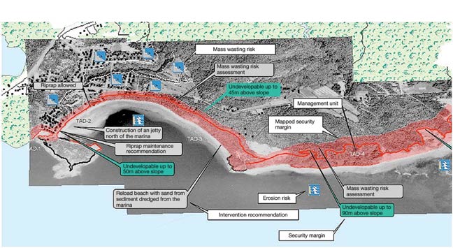
The adaptation tools currently being developed include numerical models that integrate data on marine currents, ice, waves and water levels, and systems that monitor and analyze erosion scenarios. They could also include maps showing changes in the coastline over 30 years based on erosion scenarios that take into account available data, Internet communications and exchange tools, and updated documents on bank protection methods and their impacts and ffectiveness. For example, Figure 16 was used in the adoption of regulation dealing with interim control of coastal management. An important aspect of adaptation is the development of local and regional expertise among decision-makers and front-line stakeholders in management of the coastal zone (National Institute of Coastal and Marine Management of the Netherlands, 2004). Projects underway on the impact of, and adaptations to, climate change in the coastal area of the Gulf of St. Lawrence rely on committees made up of decision-makers and stakeholders to build a regional node of persons possessing the latest scientific and technical knowledge regarding the factors that control bank erosion and coastal dynamics in their region. Completed in 2008, this project shows the importance of a balanced approach between knowledge stemming from climate science and that stemming from the assessment of on-site vulnerabilities, processes and implications, and seeks to integrate stakeholders and actors involved in the problem into the understanding and search for optimal adaptation options.
3.4. SOUTH SUBREGION
The vast majority of Quebec's population lives in the southern part of the province (Figure 17), where most of the economic activity is concentrated. The impacts of climate change here could be numerous, varied and sometimes complex, given the interrelations between infrastructure and socioeconomic activities. The rural regions have a fragile primary manufacturing economy that can be directly affected by climate, whereas the urban regions rely on a tertiary economy on which climate can act indirectly (e.g. infrastructure failure during the 1998 ice storm crisis).
3.4.1. Energy
Quebec's economy is associated with high energy consumption because of its industrial base, climate, size and way of life. In 2002, the industrial sector accounted for 39% of energy demand, while transportation totalled nearly 25% and the commercial, institutional and residential sectors consumed 37% (Ministère des Ressources naturelles et de la Faune du Québec, 2004). More than 38% of Quebec's energy needs are provided by electricity, of which 96% is water-generated. Demand reached 41.5 million oil-equivalent tonnes in 2002, an increase of 6% over 2001 (Ministère des Ressources naturelles et de la Faune du Québec, 2004).
The impact of global warming on energy demand would be lower heating needs in winter and higher air-conditioning needs in summer. The relationship between temperature, heating and air conditioning in the residential sector is well known and has been the subject of numerous analyses in recent decades (Lafrance and Desjarlais, 2006). However, knowledge of heating and air-conditioning needs in the commercial and institutional sector is more limited.
Residential heating needs in 2050 should decrease by 21% (Sottile, 2006) and air-conditioning needs should increase by 12% (Table 5), resulting in a net reduction (8.8%) in energy needs (Lafrance and Desjarlais, 2006) and considerable savings (Table 6).
In 2001, the share of commercial and industrial air conditioning was higher than the residential sector. In 2050, energy demand should fall in winter by 14.3% and air-conditioning needs in the commercial and industrial sectors should rise by 3%, for a net decline of 5 to 11% in total demand.
According to the reference scenario, energy demand (heating and air conditioning) in all sectors would decline by 2 to 3% in 2050. The increased annual savings would amount to several hundred million dollars. For southern Quebec, peak summer demand for air conditioning (between 7 and 17%) would rise, emphasizing the vulnerability of electricity production, transmission and distribution networks, as illustrated by the power failure that occurred throughout eastern North America (except Quebec) in 2003.
| Impact% on the total | Impact% on the electricity demand | ||||||
|---|---|---|---|---|---|---|---|
| Heating |
Air conditioning |
Net | Heating |
Air conditioning |
Net | ||
| Scenario | |||||||
| 2030 | |||||||
| Optimistic | -7.5 | 3.4 | -4.0 | -5.8 | 4.3 | -1.5 | |
| Median | -11.0 | 4.4 | -6.7 | -8.6 | 5.5 | -3.1 | |
| Pessimistic | -15.7 | 6.4 | -9.2 | -12.1 | 8.1 | -4.0 | |
| 2050 | |||||||
| Optimistic | -10.5 | 5.5 | -5.1 | -8.5 | 6.6 | -1.9 | |
| Median | -15.2 | 8.3 | -6.9 | -12.3 | 10.0 | -2.3 | |
| Pessimistic | -21.1 | 12.3 | -8.8 | -17.1 | 14.8 | -2.3 | |
| Baseline scenariio | Optimistic | Median | Pessimistic | |
|---|---|---|---|---|
| Residential | 2030 | -197 | -329 | -453 |
| 2050 | -229 | -313 | -397 | |
| Commercial | 2030 | -77 | -139 | -206 |
| 2050 | -104 | -166 | -259 | |
| Industrial | 2030 | -56 | -83 | -118 |
| 2050 | -82 | -117 | -163 | |
| Total | 2030 | -330 | -552 | -776 |
| 2050 | -415 | -596 | -820 | |
Adaptation strategies
Planting trees and the use of shutters, more reflective surface coverings, green roofs and low-energy cooling systems (fans and evaporation air-conditioning systems) would lessen the rise in air-conditioning needs and increase the comfort level of residences without air conditioning. Since houses last more than 50 years, their design must be adapted to include the installation of efficient air-conditioning systems (Lafrance and Desjarlais, 2006). It would be useful to have a better understanding of the impact of more frequent extreme climate events on power grid behaviour and to study the impacts of diverse alternate climate scenarios (Lafrance and Desjarlais, 2006). With Quebec's electricity transmission networks also supplying the United States, hydroelectricity production presents an opportunity for new market development, while reducing emissions from local thermal generating stations (Lafrance and Desjarlais, 2006).
3.4.2. Agriculture
Agricultural activity is concentrated primarily in the south subregion, an area favourable for agriculture due to its climate and fertile land. In response to various socioeconomic factors, the area under cultivation declined from 2.5 million ha in 1941 to 1.8 million ha in 2001 (Statistics Canada, 2002). Agricultural activity will continue to change due to a variety of factors, including climate change, that can result in both business opportunities and income loss, in both the quantity and quality of agricultural production and in the use of inputs (water, fertilizer, herbicides and pesticides).
Present agro-climate situation
The length of the growing season is a fundamental agro-climate factor that determines crop choice and yields. According to Yagouti et al. (in press), growing degree days increased by 4 to 20% between 1960 and 2003 in the western and central parts of southern Quebec, making the season more favourable for most crops.
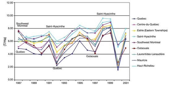
Past year-to-year climate variability makes it possible to assess the current sensitivity of agriculture to climate conditions. Over the 1967 to 2001 period, the greatest reduction in corn yield took place in 2000 (Figure 18), a year marked by excessive moisture and insufficient sunshine to promote growth (Environment Canada, 2002). Consequently, crop insurance compensation for corn reached a record level of $97 million in 2000, compared to $191 000 in 1999 (La Financière agricole du Québec, 2006). During this period, regional differences were also evident in the impact of climate variability because of different biophysical environments - soil type, topography and temperature (Bryant et al., 2005).
Climate change impacts on Quebec agriculture
A considerable increase in thermal indices and growing season length for corn, soybeans, spring cereals and forage plants is predicted in the coming years (Bootsma et al., 2004, 2005a, b). On the other hand, barley would be less favoured by these changes. In addition, there is a greater probability of water stress during the growing season since, on average, possible increases in precipitation cannot offset the increased evaporation rates that accompany higher temperatures. Since the efficiency of water use by plants increases under an atmosphere enriched in CO2 (Bunce, 2004), it remains difficult to assess the combined impacts of these different factors on crop productivity.
Excess water is also devastating to agriculture. Along with the question of water inputs, consideration must be given to changes in the intensity and the rain/snow ratio of precipitation (Nearing et al., 2004), since these factors influence runoff, soil erosion and water quality. The adaptation choices of farm producers can increase these anticipated risks when they expand surface areas by adopting crop management practices that leave soil exposed to erosion, or else mitigate the risks by improving soil conservation practices or water resources management practices (Madramootoo et al., 2001).
Horticultural production is particularly sensitive to water and thermal stress. These conditions also affect livestock production. The loss of at least 500 000 poultry in July 2002, despite the use of modern ventilation systems, shows the gravity of heat waves.
Climate conditions outside the growing season will also have impacts on agriculture. According to Rochette et al. (2004), there would be less risk of damage to fruit trees from the first autumn cold, but a higher probability of damage due to hardening losses. For forage plants, a reduction in snow cover and increase in winter rains would increase winter mortality risk despite autumn conditions more favourable to hardening (B élanger et al., 2002). Less severe winter conditions would result in greater weight gain for beef cattle raised outdoors and reduce heating requirements for poultry and hog barns.
Changes in pathogen, weed and insect populations are inevitable. However, most studies lack an assessment of the magnitude of these impacts. Scherm (2004) explained this as being due to the sometimes large differences between climate scenarios, the existence of non-linear responses of biological systems to environmental parameters and the unpredictable capacity of organisms to adapt genetically to the new environmental conditions.
Not only are there many complex interactions between climate factors, but the role of decision-makers (producers, consultants and other stakeholders) is crucial. For these reasons, preparing an integrated picture of impacts and the potential adaptation of farming to climate change requires that the decision-making context of producers be taken into account (Wall et al., 2004). The European ACCELERATES project (Assessing Climate Change Effects on Land Use and Ecosystems; Rounsevell et al., 2006) attempts to integrate diverse biophysical and socioeconomic models in order to assess the future sensitivity of European agroecosystems. Rounsevell et al. (2006) noted that the most important impacts are related to economic rather than climate scenarios, and that the inherent variability of results prevents drawing clear conclusions as to the future of agriculture. The challenge for agriculture is to properly define the questions and pertinent applications of climate scenarios based on its own strengths and weaknesses, and to appropriately integrate its own relevant socioeconomic dimensions into these scenarios.
Adaptation strategies
At the farm enterprise level
Producers feel they possess the tools and methods to adapt the management of their farms to climate change, at least in the medium term (André and Bryant, 2001; Bryant et al., 2007). As for livestock production, recommendations exist to help producers care for livestock during hot spells in order to reduce their stress (Blanchard and Pouliot, 2003). They focus on the density of livestock indoors and their feeding, as well as on ventilation and misting of buildings. Outdoor livestock production would benefit from more shelters and drinking troughs.
With respect to crops, planting and harvest dates will be adapted to changes in the growing season. Producers will also be able to choose varieties currently used in more southerly regions. Although crop diversification is often considered as a risk management strategy related to climate change, Bradshaw et al. (2004) concluded that, despite the regional diversification of agriculture on the Canadian Prairies observed since 1994, the farms themselves have become more specialized.
Different agricultural practices, such as the establishment of riparian strips, management of field residues and fertilizer application timing and methods, have been developed to protect environmental quality. They could be re-assessed and strengthened if meteorological events such as precipitation and drought become more intense. Besides, a longer growing season would promote the establishment of cover crops that protect the soil against erosion and leaching of nutrients after harvest of the main crop.
At the institutional level
Many programs and regulations establish standards for farm practices. It should be noted that the rules concerning the capacity of manure storage facilities and the deadline dates for seeding, crop harvests and manure spreading are all connected to anticipated climate conditions. When these standards are revised, it would be timely to consider the changing climate and encouraging producers to adapt their practices accordingly.
With the support of government resources, certain losses related to problematic climate conditions can be prevented or reduced. The Plant Protection Warning Network (R éseau d'avertissements phytosanitaires) provides producers with information on the presence and evolution of crop pests and the most appropriate response strategies based on forecasts made by mathematical models using climate data. Bourgeois et al. (2004) emphasized that climate evolution will make it necessary to revise these models to take into account non-linear responses to higher temperatures.
The same applies to the water issue, which requires planning and co-ordination of adapted activities at the regional level. Several micro-irrigation projects are already proceeding in horticultural crop fields. This method allows for more effective use of water and represents a gain for the environment.
3.4.3. Water management
Surface water
Surface waters represent about 80% of the water volume used in Quebec (Mailhot et al., 2004; Rousseau et al., 2004). Although this resource is abundant in Quebec, the impact that climate change will have on it must be taken seriously (Rousseau et al., 2003; Nantel et al., 2005). There are two aspects to consider: 1) the impact on available quantity and raw water quality (Hatfield and Prueger, 2004; Booty et al., 2005); and 2) the impacts on land uses or users (Lauzon and Bourque, 2004; Lemmen and Warren, 2004). For example, the impacts on water availability will be linked to changes in the frequency and magnitude of low flows and droughts (Institut national de recherche sur les eaux, 2004), whereas the vulnerability of drinking water supply systems will depend on the magnitude of those changes (qualitative and quantitative), but especially on the capacity of infrastructure and organizations to cope with the changes, an area about which few evaluations have been done to date.
In addition to supply, the various uses of water are viewed as economic and regional development tools. In both rural and urban areas of the south subregion, there are major and numerous different water uses, including removals for various purposes (bottled water, industrial, municipal, aquaculture, agriculture and mining) and on-site use (hydroelectric production, river transportation, recreation, fisheries and wastewater evacuation; Vescovi, 2003; Ouranos, 2004). Given both the demographic and socioeconomic trends presented above and the fact that 65% of the population of Quebec already live in urban watersheds and 32% live in moderately urban watersheds (Statistics Canada, 2005), the pressure on watersheds in southern Quebec will result in increased vulnerability. Added to this is the possibility suggested by Table 4, and presented in recent studies (Turcotte et al., 2005; Rousseau et al., 2007), that climate change leads to summers characterized by higher temperatures but without sufficient additional precipitation to offset the increased evaporation rates, thus leading to hydroclimatic changes that are likely to exacerbate use conflicts. These conflicts have already generated interest among several groups, resulting in the adoption of a new water policy (Government of Quebec, 2002), which is a tool that can assist in reducing vulnerabilities.
As for hydroelectric production, even though the expected impact of climate change - especially a late start to freeze-up and an early spring - tends to favour production, the constraints associated with ice cover upstream from power stations would be emphasized. In fact, a recurring formation of ice cover in the same winter would affect the performance of power stations over a long period. Also, the more frequent alternation of freeze-thaw periods could cause problems of frazil ice and more frequent ice jams, and reduce the output of these power stations accordingly, while posing other risks. Beltaos and Prowse (2002) suggested that an increase in frequency of winter mild spells tends to increase the risk of ice jams in other regions of the country.
St. Lawrence River
A synthesis of the state of knowledge specific to this major river, which drains southern Quebec and central North America, is provided in a study by Ouranos (2004) entitled S'adapter aux changements climatiques (Adapting to Climate Change). In another study, Croley (2003) used the output of four global climate models to estimate that outflow from Lake Ontario to the St. Lawrence River would be reduced by 4 to 24% annually. Using a similar method, Fagherazzi et al. (2005) concluded that there would be a slight reduction in flow of between 1 and 8% from the Ottawa River, the main tributary of the St. Lawrence. Combining these two results, Lefaivre (2005) concluded that water levels on the St. Lawrence would be reduced in the Montr éal area by a maximum of 0.2 to 1.2 m, depending on the scenario. This would considerably reduce the area of open water in the river, particularly in Lake Saint-Pierre, which is shallow. A cascade of effects could occur along the entire length of the river that are similar to those identified above but potentially of a different magnitude, given the size of the area affected.
In this context, the Comité de concertation navigation du Plan d'action Saint-Laurent (Navigation Committee of the St. Lawrence Action Plan) examined adaptation options that would make it possible to maintain maritime and harbour activities at their current level (D'Arcy et al., 2005). The study explored various adaptation options and found that, if water level reductions are small, improving long-term predictions would make it possible to optimize the safety margins established by overseas shipping companies, thereby reducing their vulnerability. If the reductions are more significant, adaptations of an organizational nature, such as the restructuring of maritime transport and its infrastructure, or of a technological nature, such as the adaptation of vessels to reduce the draught required, appear to be theoretically feasible. However, these could prove difficult to apply in a context of increased commercial activity and given the major investments required for such a reorganization ($260 million to $1 billion). Finally, adaptations of the physical environment (dredging, regulation structures) can reduce the vulnerability of shipping, but would cause significant environmental impacts. The effects and costs associated with compensation measures would be difficult to assess precisely.
A number of initiatives that illustrate the efforts being made by various authorities to minimize the risks and conflicts that could be caused by a significant decline in water levels merit discussion. Several years ago, the International Joint Commission (IJC) initiated an extensive study to evaluate various flow regulation plans. Several of the management plans tested included flow analysis under climate change conditions (International Joint Commission, 2006), and the options that were proposed could help with adaptation. This evaluation even addressed items such as the advantages of wetlands relative to the economic advantages and losses of regulation plans. Furthermore, in December 2005, the governments of Quebec, Ontario and the eight American Great Lakes states signed the Great Lakes -St. Lawrence River Basin Sustainable Water Resources Agreement, which regulates removals of water from the entire watershed in all sectors and prohibits out-of-basin removals. The agreement makes explicit reference to climate change and the precautionary principle (Great Lakes -St. Lawrence River Basin Sustainable Water Resources Agreement, 2005).
Groundwater
This resource provides 20% of all drinking water in Quebec. Rivard et al. (2003) observed that the annual groundwater recharge seems to have remained stable or declined slightly in recent decades in Quebec and the Maritimes, while precipitation and temperatures have tended to increase. Significant declines in groundwater availability would have major impacts, especially in rural areas where a large proportion of the population (26% in Chaudi ère-Appalaches versus 10% for Quebec as a whole) is supplied by groundwater from individual wells (R égie régionale de la santé et des services sociaux de Chaudière-Appalaches, 2001). Their vulnerability is all the greater given that knowledge of groundwater in Canada remains incomplete. In Quebec, the mapping of the aquifer of the Ch âteauguay River basin (Côté et al., 2006) is a step in the right direction. Moreover, several research projects in this same basin, started in 2006 and supported by Ouranos and the National Science and Engineering Reseach Council (NSERC), are seeking to improve knowledge of systems that integrate both surface water and groundwater using coupled modelling. This knowledge will contribute to the study of the vulnerability of these aquifers on a local scale.
Management Plans for Southern Watersheds: the Case of the Upper Saint-François River Watershed
To assess the capacity of existing management plans for southern watersheds to adapt to anticipated hydroclimate impacts, a pilot project was conducted in the Upper Saint-Fran çois River basin, located in the south-central part of Quebec (Turcotte et al., 2005; Fortin et al., 2007). On the one hand, the approach was based on climate change scenarios (Chaumont and Chartier, 2005) and hydrological modelling on a day-by-day basis to assess the impact on basin hydrology. On the other, it was based on a model simulating the daily application of management plans for the Saint-Fran çois and Aylmer reservoirs.
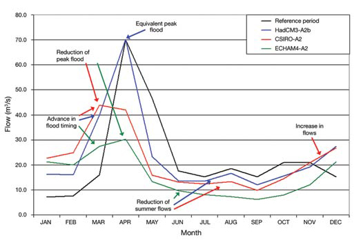
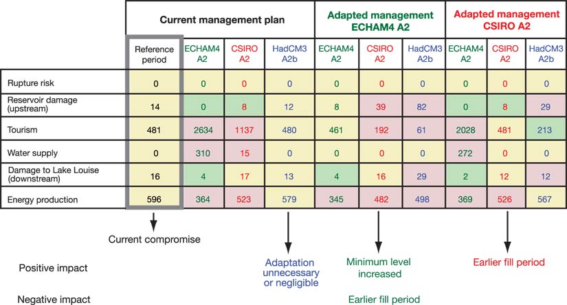
The results are similar to those obtained for the Châteauguay River watershed (see Case study 3): the impacts on the intensity of spring (earlier and generally smaller), summer and fall peak flows, on winter flows, on the magnitude of low waters (sustained winter low waters and weaker summer low flows) and on the intensity of annual increases in volume vary depending on the general circulation model and GHG emissions scenario used (Figure 20). In the approach dealing with the analysis of management plans, the modelling exercise shows that climate change, as simulated by the ECHAM4 and CSIRO models, would result in a modification of current arrangements for the different uses of water from the reservoirs (Figure 21). No major adaptation would be required if the climate changes as simulated by HadCM3. In the first two cases, necessary adaptation measures would include filling the reservoir earlier and raising minimum levels.
CASE STUDY 3: Flooding in the Châteauguay River Watershed
The example of the Châteauguay River watershed is used to illustrate the problem of floods, particularly spring floods, in a climate change context. As demonstrated by several authors, flooding caused by high waters in spring remains one of the most damaging extreme hydroclimatic events (Ashmore and Church, 2001; Brissette et al., 2003; Ouranos, 2004) to which Quebec is continually attempting to adapt (Ministère de la Sécurité publique du Québec, 1996). To analyze the potential impact on water resources, Caron (2005) and Mareuil (2005) led a modelling exercise on this watershed based on the development of a stochastic climate generator, including monthly temperature and precipitation anomalies taken from three general circulation models: CGCM2, HadCM3 and ECHAM4.
The 2050s scenarios taken from the ECHAM4 model indicate a statistically significant reduction in spring floods for return periods of 2 to 500 years. The HadCM3 and CGCM2 models show similar results (but not statistically significant), namely a reduction in floods for short return periods and an increase for longer return periods. For the summer period, HadCM3 shows a slight (but not statistically significant) increase in flood intensity for all return periods. The ECHAM4 and CGCM2 models show a statistically significant reduction of 8 to 10% in flood intensity.
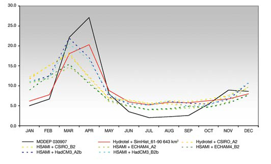
Another hydrological simulation was conducted on the Rivière des Anglais, a tributary of the Châteauguay River (Figure 19). The Hydrotel and HASMI models, using six future climate scenarios (the models ECHAM4, HadCM3 and CSIRO, to which were applied GHG emission scenarios A2 and, B2), show earlier peak floods, moving up from late April in the 1961 to 1990 period to early March in the 2050s. There would also seem to be a change in flood volume: HadCM3 projects a rise in spring flood volume, whereas ECHAM4 shows a major decline in flood volume. The CSIRO model presents results falling between those of the two other models. These discrepancies are explained by differences in the projected temperature and precipitation change shown by these climate models. Finally, the example seems to indicate a decline in low water flow caused by a rise in evapotranspiration volume, despite a projected rise in precipitation (Pugin et al., 2006).
Notwithstanding this observation, assessments on Norton Creek, a sub-basin of the Rivière des Anglais, of water content in upper soil layers using a balance model show an increase in irrigation water needs of agricultural land caused by the rise in evapotranspiration of plants resulting from higher temperatures. By taking into account certain environmental constraints related to removal of water from waterways, and despite the relative scattering of results from the different climate scenarios used, the study concludes that, to maintain the proportion of future needs for irrigation water that is currently being provided by surface water will require a more concerted approach to planning, based on integrated watershed-scale management of this resource (Pugin et al., 2006).
Finally, Leclerc et al. (2005) indicated that floods caused by ice jams at Châteauguay itself result mainly from the behaviour of the hydrological basin and the presence of ice accumulating on the river. As for floods in open water, they would be the result of fluctuating St. Lawrence River water levels, causing the recurring floods experienced by this municipality. So, for southern Quebec in general and the Châteauguay River watershed in particular, the expected impact of climate change takes the form of earlier and more intense spring floods. Indirectly, variations in the water levels of the St. Lawrence and Ottawa rivers and summer floods in open water can be expected.
Adaptation measures
Depending on the nature of the problem, many adaptation measures are considered, such as the rehabilitation or relocation of certain water intakes, more effective water treatment, reduced water volume loss in the system and increased reserve capacity. They target both infrastructure and management methods (a water-saving program).
Preliminary studies on flood management, such as those undertaken to solve problems related to meeting future needs for irrigation and drinking water, as well as those of ecosystems, must be addressed using an approach that favours planning based on integrated watershed-scale management of water. Large urban centres that depend on surface water seem vulnerable to change in levels of the St. Lawrence River. On the other hand, rural areas that can count on sufficiently abundant groundwater are less vulnerable in quantitative terms. Aside from quantity, the question of water contamination could be a problem, as indicated in Section 3.5.1. In general, the adaptation challenge for small municipalities with limited means is greater than for large population centres. Here again, adaptation solutions ideally involve global and integrated management adapted to the water cycle of southern watersheds as well as the Great Lakes and St. Lawrence system. They must be developed in a sustainable regional planning context that takes socioeconomic and environmental realities into account.
As for water management infrastructure, drainage systems were dimensioned using statistical recurrence criteria produced from available historical analyses of precipitation at a given site (Mailhot and Duchesne, 2005). The anticipated change in recurrence of heavy rainfall events should result in an increase in system overflows, backups and even flooding. Mailhot et al. (2007) stressed that, under the current conditions of aging infrastructure, the impact of a probable increase in intensity and probability of heavy rainfall events (Intergovernmental Panel on Climate Change, 2007) would be lessened if 1) design criteria for infrastructure and buildings were reveiwed; 2) new ways of using statistics on intense precipitation when dimensioning (Duchesne et al., 2005) were found; and, above all, 3) source control was improved through optimal city planning and maximized infiltration, especially in situations where existing infrastructure and buildings will still be in service for several decades.
Finally, adaptation strategies, which should include more robust management plans than those currently in place, will be defined with a view to improve risk management for each climate scenario, since it seems difficult at present to find a single strategy for all scenarios. The results show (Turcotte et al., 2005) that the current consensus on dam management plans must be discussed by community stakeholders even though an adaptation solution for all climate scenarios studied has yet to be defined. A preventive approach would minimize risks. More refined climate scenarios that better represent the future climate based on more advanced methods of scaling would reduce uncertainties. It would thus be possible to better prepare the community for possible changes in management rules and so ease its adaptation to the coming reality. To make consensus adoption of an adaptation strategy easier, it would be advisable to better integrate each step of the modelling (to properly understand the system studied) within the framework of integrated and participative watershed-based management. Besides, in the area of water management, just as watershed-based management has come to be recognized as one of the best climate change adaptation planning approaches, it is becoming increasingly apparent that climate change perspectives must also be integrated into watershed-based management planning. These two components naturally and mutually make a whole.
3.4.4. Tourism and recreation
Tourism, through its contribution to gross domestic product and employment, is one of the important economic activities potentially affected by climate change. Climate is the primary element affecting sports and outdoor activities, either directly (sun, fine weather, snow and ice), or indirectly (scenery and plants). It determines the nature and duration of activities involving snow and cold (skiing, snowmobiling), water (swimming, nautical activities) or autumn colours (hiking), and influences living conditions for fish and game (fishing, hunting). It can even influence the number and duration of cultural outings.
Anticipated impacts
According to Wilton and Wirjanto (1998), a 1°C rise in summer temperature would increase Canadian tourism receipts by 4%, whereas a decrease of 1 °C would have only a marginal impact in winter. The sensitivity of tourism and recreation activities to temperature varies depending on the season and includes different thresholds. Other phenomena also come into play, such as coastal erosion, water deficits in lakes and rivers, or water supply deficits (Wall, 1998).
According to Singh et al. (2006) and Scott et al. (2006), the Quebec ski industry must expect and adapt to more difficult climate conditions in the coming decades. The southern regions (Montr éal, Eastern Townships) should see an increase in mild and rainy conditions during the ski season that will shorten its length. Certain profitable periods (Christmas, Easter, school break) would be affected. However, warming (less cold and wind) would increase the number of skiable days and use of trails, especially in January and February. The cost of artificial snow-making, despite the fact that the equipment is already installed, may rise, affecting profitability and making availability of the required water a critical issue. A higher extraction volume combined with a possible drop in water levels would trigger or amplify usage conflicts (Singh et al., 2006). The importance that customers give to natural snow and the skiing quality it provides should be an advantage for Quebec because of its latitude, particularly for those ski centres whose customers come from outside the area and whose advertising campaigns have been adapted. The urban perception (rain in the city means it is snowing in the countryside) can also have consequences on business traffic. Depending on the climate model used, a study of the Ontario ski industry (Scott et al., 2002) projected a reduction in snow cover of 21 to 34%, resulting in some activities losing their popularity (snowmobile, cross-country skiing) as the season becomes shorter by up to 50%. Ice fishing is highly vulnerable to temperature warming, as safety risks for fishermen increase. Finally, events such as winter festivals would also be affected.
The golf season should be extended by two to three weeks (Singh et al., 2006), mainly through an earlier start to the season, although 75% of play occurs between July and September. There should be an increase in the number of unfavourable days because of more frequent heat waves and, possibly, summer precipitation. Greater irrigation needs due to warmer temperatures would likely become a problem and a source of usage conflicts, given lower water levels and stricter withdrawal regulations, all of which represent the sector's main challenge. Current grass varieties would deteriorate more rapidly during summer and winter mild spells, as future climate conditions encourage bacteria and other pathogens. The quality of drainage on golf courses would also be affected by the intensity and recurrence of precipitation, and it would cost more to maintain the grounds if increased evapotranspiration dried out the course. These new climate constraints would be of major concern for operators already facing keen and recent competition and needing to meet mandatory environmental standards related to the regulated use of maintenance products (Singh et al., 2006).
With regard to other summer activities, despite the lack of studies on the subject, an increase in such summer tourist activities as hiking, park use, water recreation and boating, can be assumed (Jones and Scott, 2005). Several tourist regions with a more temperate climate would benefit from temperature warming, and Quebec would be privileged compared to more southerly regions, helping its overall tourist balance despite having to contend with socioeconomic factors that could limit revenue dedicated to tourism and recreation. The negative impacts would stem from increased precipitation, heat waves and deteriorating water quality, due specifically to the spread of cyanobacteria and other harmful species (Minist ère du Développement durable, de l'Environnement et des Parcs du Québec, 2005a). Fishing would be disturbed, since fish are sensitive to small variations in temperature.
Adaptation strategies
Faced with greater market competition, constant infrastructure renewal and cost increases (artificial snow-making, electricity, property taxes), many ski hill operators believe that better understanding of future climate phenomena, which leads to better planning of investments and satisfaction of increasingly demanding and selective customers, is the best adaptation strategy. While benefiting from steady technical progress, the ski industry shows a capacity to adapt to new consumption habits, growing competition and new social phenomena, such as excessive and rapid consumption, changes in the family situation and instant access to weather forecasts, which will play an increasingly dominant role. In the case of ski centres, diversification would be one way to adapt to climate impacts and variability, and could be seen as a useful adaptation pathway when dealing with more significant changes (Singh et al., 2006).
Adaptation strategies for the golf industry deal mainly with water management, both natural inputs and land drainage. Grass quality, a major customer requirement, must be monitored to avoid increased withering. Extending the season would generate additional income if the benefits reflect on other services such as food and lodging. However, climate change does not seem to be the priority of this sector, since golf course maintenance costs are mainly related to labour and plant health products (Singh et al., 2006).
As for other summer activities, impacts on sport fishing could be mitigated by planting a vegetation cover on banks, and water quality should be more closely monitored at sites reserved for swimming.
Developing appropriate adaptation strategies requires that stakeholders in these sectors be well informed to better grasp the significance of climate change scenarios, threshold levels for activities and the various possibilities for spontaneous or planned adaptation (Singh et al., 2006). As for consumers or users of tourism infrastructure, it would be advisable to clarify their reactions to different climate thresholds for each activity and the comparative attraction of these activities under the new climate conditions.
3.4.5. Transportation
The Quebec road network is influenced by a harsh climate, the size of the province, the population distribution and heavy traffic in large population centres (Minist ère des Transports du Québec, 2006b). This particular situation increases the sensitivity of infrastructure (see Section 3.5.3) and transportation activity to climate change.
Winter maintenance
Winter driving on Quebec roads is a challenge, mainly due to difficult and changing conditions. Winter storms are predicted to be less frequent but more intense (Cohen and Miller, 2001). This should increase the complexity of managing winter road maintenance, which covers all measures taken by various parties to combat or adapt to the deterioration of driving conditions in winter. On the other hand, a winter maintenance decision support system (named DVH-6024), using information obtained from stations equipped with weather and road sensors, was set up by the MTQ in 1999 (Tanguay and Roussel, 2000). The development and application of road weather technologies continues, particularly in the case of fixed and mobile instrumentation deployed across the province.
Road surface
In the south subregion, temperatures can change by up to 25°C in a few hours. For more than four months, the ground freezes to depths of 1.2 to 3 m, and precipitation can reach 1000 mm a year (Minist ère des Transports du Québec, 2006c). In spring, after resisting deformation due to deep frost, the road must once again be able to support heavy loads while pavement strength is reduced by 40% (Frigon, 2003). Scenarios derived from climate models suggest an increased incidence of mild spells (Government of Quebec, 2006c). Since freeze-thaw cycles and the presence of increased water on the road exacerbate surface deterioration, the new climate conditions will have an impact on pavement conditions and, consequently, on maintenance costs. The rapid evolution of methods and knowledge concerning road surface design and the emergence of new technologies and products have led the MTQ to adapt diverse technologies to the Quebec situation and to design and fine-tune new pavement assessment equipment. These activities, conducted in collaboration with the university community, have been the subject of meetings and technical exchanges, as well as joint research projects with several countries, including France (Dor é and Savard, 2006) and the United States.
3.4.6. Context specific to the south subregion
A high level of socioeconomic activity is concentrated in southern Quebec, which places significant stress on the environment and inevitably complicates the analysis of vulnerabilities and the prediction of climate change impacts on both the natural and human systems. In fact, the complicating factors are similar to those of other highly developed, densely populated regions:
- a high and growing population density
- growth of the built environment serving a heavily service-oriented economy
- ubiquity of institutions with important investment and regulatory capacities
- change in public perceptions with respect to activities less and less directly related to climate conditions and ability to choose from among a wide range of historical choices when making land-use decisions
- pressures brought on by urbanization of watersheds that were previously largely agricultural or forested.
This dynamic is also influenced by global socioeconomic issues and associated climate impacts that are likely to have repercussions in the south subregion (see Chapter 9). In this context, and as illustrated in Sections 3.4.1 to 3.4.5, the available studies are essentially sectoral, except when dealing with water management, in which case the studies start quantifying and integrating the impacts of different users on the management rules.
The weather event that best illustrates the vulnerabilities associated with a high degree of infrastructure interdependence is the ice storm of January 1998. In that event, the impacts hit several sectors simultaneously, generating a complex series of effects that, when combined, led to the failure of socioeconomic activities and to outcomes whose cost has been estimated at several billion dollars (Ministère de la Sécurité publique du Québec, 1999). Since all infrastructure or societal choices are actually socioeconomic compromises between what is considered acceptable costs and desired benefits, climate change could affect this ratio. These compromises, once considered acceptable, could be revisited on the basis of past or anticipated extreme weather events. However, while quantitative climate studies on the links between climate change and extreme weather events are emerging (Tebaldi et al., 2006), they rarely allow an assessment of impacts at the infrastructure, building or community scale. An increase in heavy precipitation simulated by one version of the CRCM for the south subregion would affect the urban area, overloading municipal infrastructure and triggering flash floods in rural watersheds (Mailhot et al., 2007). Various tools (Secretan et al., 2006), policies (Government of Quebec, 2006c) and land uses (Mailhot et al., 2007) would help reduce the vulnerability. Little is known about links between the regional climate and the geology of the south subregion, but most of inhabited Quebec lies on clay soil subject to landslides (see Case Study 4). This area is characterized by significant urban sprawl, and any increase in the number of landslides would have significant consequences for the security of people and property. As mentioned in Chapter 2, lack of knowledge about a potential problem can significantly affect the adaptive capacity of a system.
3.5 OTHER INTEGRATED ISSUES AT THE PROVINCIAL SCALE
This section will present the key issues for the four subregions, followed by a discussion of other sensitivities and impacts at the provincial level. Although this discussion cannot be exhaustive, given the potential scope of the problem and the limited number of pertinent studies on the subject, the objective is to obtain a clearer overall picture of the situation and to examine certain specific issues that have not previously been discussed. The discussion is based on the three key elements identified in Figure 1.
CASE STUDY 4: Landslides in Quebec
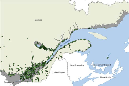
Hundreds of landslides occur every year in Quebec, most of them in clay soils (Figure 22) in areas experiencing significant population growth, as discussed in Section 2. Water infiltration into the ground following the spring snow melt or during rainfall events is one of the two major causes of landslides, others being the gradual erosion of stream banks or destabilizing human activity. Extreme weather events often take the form of heavy rainfall that frequently causes major floods. This is shown by the many landslides that occur in spring or during exceptional events - such as the torrential rains of July 1996 in Saguenay-Lac-Saint-Jean, when more than 1000 landslides occurred in less than 36 hours (Ministère des Transports du Québec, 2000).
Although the link between these events and climate change does not seem obvious, it appears that the increase in this phenomenon in a region experiencing significant urban sprawl can generally be linked to an increase in extreme precipitation events. Nevertheless, the Saguenay flood improved understanding of the phenomenon through mapping of certain regions at risk, thus adding to the historic efforts initiated by the 1971 landslide at Saint-Jean-Vianney (Figure 23) to assess vulnerabilities and promote a safer use of the territory.
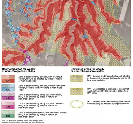
Although it is valid for all of Quebec, the present section is particularly pertinent for the socioeconomically dominant south subregion that will see climate change combined with interrelated environmental and socioeconomic changes that have already been underway for several decades. The vulnerability of this subregion, and Quebec as a whole, will be influenced by climate changes, weather events, information distribution, international negotiations, public perceptions, the market economy and the public policies of different levels of governments.
3.5.1. Sensitivity and adaptation of populations
Climate change presents a challenge for human health. Its impact is either direct (e.g. death due to heat stroke), or indirect (e.g. outbreak of pathogenic insects). On the other hand, populations show different degrees of vulnerability to climate change, which complicates the introduction of adaptation measures to limit anticipated impacts.
Impacts and sensitivities
Impact of Mean Warming on Mortality
In Quebec, the anticipated rise in mean temperatures may lead to an increase in annual mortality rates (Figure 24). The study by Doyon et al. (2006) predicted a rise in summer mortality (all non-injury causes) on the order of 2% for 2020 and 10% for 2080, according to the A2 scenario (Intergovernmental Panel on Climate Change, 2001a); this increase is not entirely offset by lower winter mortality. Hence, the rise in the annual mortality rate would be about 0.5% for the 2020 period and 3% for 2080, a conclusion similar to that reached for many cities in the United States by Kalkstein and Green (1997), who estimated the number of deaths on hot days to be three times higher than on cold days. Keatinge et al. (2000) predicted a net annual drop in mortality in the United Kingdom due to decreased mortality during winter, which does not seem to be the case in Quebec. However, these simulations do not consider population aging - which can substantially increase mortality rates - nor do they consider physiological and environmental adaptation measures or those related to housing - which can reduce mortality by the same amount. In Québec, there will be more and more people aged 65 and over. Their proportion rose from 9.7 to 12% between 1986 and 2001, and should reach around 24% in 2025 (Institut de la statistique du Québec, 2000). What's more, the study by Doyon et al. (2006) confirmed that the group aged 65 and over is historically much more vulnerable to climate warming than the group aged 15 to 65.
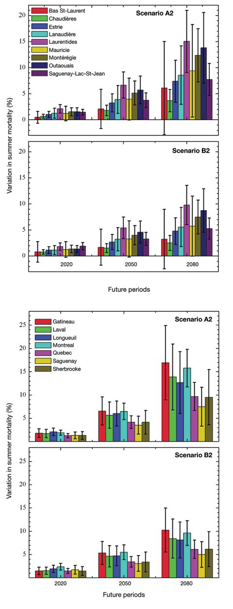
The direct health effects of violent rain and floods include injury, heart problems and death by drowning. The indirect effects take the form of infectious diseases, such as conjunctivitis and dermatitis, caused by contaminants present in the flood waters and gastroenteritis due to microbiological contamination of drinking water sources. Respiratory problems linked to mildew are also listed. Victims and aid workers would suffer post -traumatic stress that could lead to depression, anxiety, psychosocial troubles and even suicide (World Health Organization, 2005).
The direct health effects of winter storms include injury, chilblain, hypothermia and sometimes death, with 100 Canadians dying every year (Institute for Catastrophic Loss Reduction, 2005).
In 2004, lightning was responsible for about 12% of forest fires (Organisation de patrouilles de la Soci été de protection des forêts contre le feu, 2006). In addition to their considerable economic impact on the forest industry, forest fires emit chemical compounds into the atmosphere (e.g. particles, nitrogen oxides, carbon monoxide, organic compounds). In humans, these emissions can cause irritation of respiratory pathways, worsening of chronic diseases and poisoning due to smoke inhalation. Acute syndromes may also occur in firefighters and forestry workers exposed to smoke for long periods (Dost, 1991). The indirect effects on health are post -traumatic stress, possibly leading to suicide (World health Organization, 2005), particularly in the case of a significant economic loss (e.g. residential fire or plant fire with job losses). However, the current scenarios associated with the boreal forest do not predict significant changes in precipitation or forest fires in Quebec, but uncertainty remains (Ouranos, 2004).
In January 1998, freezing rain fell on Quebec for five consecutive days, leaving more than 3 million people without electricity, some for as long as 40 days. This event was responsible for 21 deaths and 200 cases of carbon monoxide poisoning (Roy, 1998), mainly in the Mont érégie and on the Island of Montréal (Tremblay et al., 1998). Laplante et al. (2004) conducted a study on 224 women who were pregnant at the time or became pregnant in the three months following the storm. 'Objective' stress factors (number of days without electricity) and 'subjective' reactions (post-traumatic stress syndrome) were assessed. The results show a connection between major prenatal stress in the mother and elevated perinatal mortality, differences in psychomotor development in children aged 2 to 5.5 years and behavioural problems in children from 4 to 5.5 years old.
In the north, recent climate trends may be related to the avalanche at Kangiqsualujjuaq in 1999, where 9 people died and 25 were injured (Public Security Canada, 2006). Other, less tragic incidents occurred in other villages during the same time. In Salluit (Hudson Strait), a landslide occurred in 1998 following failure of the active soil layer. In Tasiujaq (Ungava Bay), permafrost thawing was in part responsible for subsidence of a building and deformation of the airport runway (Allard et al., 2002). In addition to putting lives in danger, these events cause considerable insecurity among residents who depend on air transport for food supplies and medical evacuations to hospitals.
Impact of heat waves and of the urban heat island effect on health
Higher temperatures, a daily Humidex that has been rising during the past four decades in Montréal and Québec City, and more frequent and intense heat waves represent important risks for human health (Environment Canada, 2004a, b). Adding to these events is the urban heat island effect, produced by asphalt surfaces and infrastructure materials that absorb heat and raise the ambient air temperature by 0.5 °C to 5.6°C in urban settings (Oke, 1982).
The heat can cause discomfort ranging from weakness to consciousness disorders, as well as fainting and heat stroke that can cause death (Besancenot, 2004). Indirectly, heat can also exacerbate such chronic diseases as diabetes, respiratory insufficiency and kidney failure. Sunshine also contributes to the formation of ground-level ozone in urban areas, a gas harmful to human health. Ground-level ozone can irritate the eyes and respiratory pathways, reduce respiratory function, exacerbate respiratory or heart disease, and even cause premature death (Health Canada, 2004).
Southern populations are more sensitive to an increased frequency of oppressive heat episodes, whereas people in the north suffer more from the rise in temperature, since they are not acclimatized (Health Canada, 2005). Several scientific studies (Commission de la sant é et de la sécurité du travail, 2004; Direction de la santé publique de Montréal, 2004) referred to people with higher vulnerability based on environmental characteristics (e.g. housing, work, access to cool places) or personal characteristics (e.g. diseases, disabilities, age). The study by B élanger et al. (2006) shed new light on the vulnerability of certain groups to heat. It highlighted certain known factors and documented new relationships that can exacerbate the impact of heat waves, including 1) elderly persons living alone; 2) economic precariousness; 3) limited mobility; 4) chronic neurological problems (epilepsy, multiple sclerosis); 5) social support; 6) type of housing (including certain types of residential buildings); and 7) access to recreational activity during heat waves (such as bathing areas).
The relationship between multiple-storey residential buildings and higher mortality during heat waves has been established by several researchers (Klinenberg, 2002; Dixsaut, 2005), and public perceptions throughout Quebec have also recognized this vulnerability (Bélanger et al., 2006).
A tracking study conducted in the Eastern Townships on the use of prescription drugs during intense heat episodes showed the importance of the warnings issued by pharmacists (Albert et al., 2006). A significant percentage (30.2%) of people aged 65 and older take a type of prescription medication whose absorption can be affected by dehydration, or that can impede caloric loss and kidney function. Nearly 5% of elderly persons had three or more prescriptions for drugs of this type to be taken simultaneously.
Effects of air pollution on health
The World Health Organization recently presented the hypothesis that a warmer and more humid climate would increase the atmospheric concentration of certain pollens and thereby provoke an outbreak of allergic disorders such as allergic rhinitis and asthma (McMichael et al., 2003). Allergic rhinitis is a serious public health problem in industrialized countries, altering the quality of life of affected populations and causing absenteeism and loss of productivity at work. The costs related to hospitalization, drugs and medical consultations are also significant (Breton et al., 2006; Garneau et al., 2006). In the Qu ébec City and Montréal regions, a rise in both pollen concentrations and frequency of medical consultations for rhinitis was noted between 1994 and 2002. Allergic rhinitis due to pollen and other allergens, or resulting from a non-specific cause, ranks 5th (9.4%) among declared health problems (Institut de la statistique du Qu ébec, 2000). This prevalence seems to have increased by 6% since 1987 (Garneau et al., 2006), but many external factors could also contribute to it apart from climate.
According to Garneau et al. (2006), allergic rhinitis affects mainly the 15 to 24 age group (14.6% of the Quebec population) and the 25 to 44 age group (13.6%). Medical consultations for the 1994 to 2002 period were more frequent among women than men. However, for the 0 to 14 age group, they were higher for males. These results are consistent with those of studies by Banken and Comtois (1990) and Goulet et al. (1996) that reported a maximum incidence of allergic rhinitis among those 0 to 24 years of age.
The use of fossil energy produces not only a significant amount of CO2 emissions but also of precursors to ground-level ozone and fine particulate matter. Climate change would increase temperature extremes, resulting in a rise in the frequency and duration of heat waves and smog (House and Brovkin, 2005; World Health Organization, 2005). In Quebec, low-altitude ozone levels have been rising constantly during the past 15 years on a seasonal mean basis (Environment Canada, 2005), although the number of acute episodes varies greatly from one year to another. With greenhouse gas increasing by 6% from 2001 to 2003 (Institut national de santé publique du Québec, 2006), this risk remains significant and growing, to varying degrees, for most of the south subregion.
Effects of climate change on the quantity and quality of water resources
In the south subregion, if the projected effects of climate change result in lower stream levels and flows, a change in precipitation (see Section 3.4.3) and a rise in salinity levels of the St. Lawrence River (Bourgault, 2001), this would be a serious concern since more than 70% of the public takes its drinking water from surface water (Minist ère du Développement durable, de l'Environnement et des Parcs du Québec, 2004a). The risks of microbial, chemical and natural biotoxin contamination are also higher. Moreover, water shortages, linked to reduced capacity of aqueducts, present a higher risk in case of fire, with injury, death and considerable psychological impact for families whose personal property is destroyed (Enright, 2001).
Water-borne diseases can appear if pathogenic micro-organisms migrate to groundwater or surface water sources used for water supply (Canadian Council of Ministers of the Environment, 2005a, b). Phosphorus, sunshine and temperature are the key factors responsible for blue-green algae blooms (Agence de d'éveloppement de réseaux locaux de services de santé et de services sociaux, 2003). In Quebec, this phenomenon has already affected about 84 lakes and streams between 1999 and 2003 (Institut national de sant é publique du Québec, 2006) and has led to prohibitions on water consumption and bathing, but without any human illness being reported so far. Cyanotoxins, produced by cyanobacteria, can cause skin irritation and serious liver or nerve damage, through both skin contact and water ingestion (American Water Works Association, 1999; Agriculture and Agri-Food Canada, 2003). Young children, the elderly and persons with chronic diseases are more at risk of developing severe symptoms resulting from water contamination. Persons practicing water activities are particularly vulnerable to contamination by natural biotoxins (Agence de d éveloppement de réseaux locaux de services de santé et de services sociaux, 2003; Ministère du Développement durable, de l'Environnement et des Parcs du Québec, 2005b). The general public would be affected by water shortages at the physical and psychological levels; families already in precarious situations would experience more insecurity with respect to food supply by having to buy their water (Direction de la sant é publique de la Montérégie, 2004).
Water-borne diseases (transmitted through protozoa, bacteria or viruses) are common in Nunavik and, from 1990 to 2002, certain of these diseases (e.g. giardiasis, salmonellosis) were found in proportionately higher numbers there than elsewhere in Quebec, while the number of other types of infectious diseases was lower (Furgal et al., 2002). Climate change can affect water supply (individual or community systems), degrade the permafrost and contribute to saltwater intrusion in aquifers, thereby exacerbating a situation that is already cause for concern. For many villages, burying garbage in the permafrost would pollute groundwater, streams and adjacent lands (Furgal and Seguin, 2005). In Nunavik, one person in five is under five years of age - a group at risk for gastroenteric diseases because of the weakness of children's immune system (Martin et al., 2005b). The feared changes highlight the urgent need to improve environmental monitoring and health surveillance systems for quick detection and treatment of health problems related to water quality (Owens et al., 2006). A pilot project related to this is currently underway in Ungava Bay within the framework of the ArcticNet Network of Centres of Excellence (Gosselin, 2006).
In 2004, QANUIPPITAA, the health survey among the Inuit of Nunavik (Régie régionale de la santé et des services sociaux Nunavik, 2004), conducted in all villages of the subregion, prompted the development of new strategies. During the visit of the Amundsen, an icebreaker for scientific research, 232 homes and 19 raw water supply sites were visited as part of an ArcticNet project (Martin et al., 2005c) associated with the health survey. This survey provided both an understanding of drinking water consumption habits of residents and an overall picture of bacteria levels in the water consumed. It will be used to develop important environmental and health databases for the north subregion, which can then be used for climate-based tracking.
A similar survey was conducted among the Cree population of Mistissini (Nituuchischaayihtitaau Aschii, 2005). It will contribute to the creation of a valuable database on changes in water quality during the next seven years in First Nations communities of the north subregion.
Impacts of climate change on the emergence and intensification of zoonotic and vector-borne diseases
Climate change would modify the distribution range of parasites and diseases transmitted by animals, insects and ticks, resulting in a rise in existing infectious diseases and the appearance of new infectious diseases in Quebec.
Zoonotic diseases include the hantavirus pulmonary syndrome (HPS), for which certain rodents are the
vectors. A warmer climate would result in the propagation of rodents into new areas. Many indigenous rodents carry this disease: a first case was reported in Quebec in 2005 (Direction de la santé publique, 2005). Rabies is another disease that can be transmitted to humans through bites or scratches received from infected animals. Climate change would give rise to changes in habitat and length of hibernation and breeding conditions of vector animals, leading to the northward spread of diseases (Ontario Forest Research Institute, 2003). Quebec presently has few mosquito species that are vectors of viral diseases transmissible to humans. However, a few species present in the south subregion are vectors for the West Nile virus, St. Louis encephalitis, La Crosse encephalitis and eastern equine encephalitis (Institut de santé publique du Québec, 2003a, b). Encouraged by milder winters and longer summers, the mosquitoes live longer and the season during which the St. Louis encephalitis virus can be transmitted is extended. La Crosse encephalitis is endemic to the United States, and the Snowshoe Hare variety of this virus is present in Quebec, as is the eastern equine encephalitis virus, with no cases reported so far (Institut de santé publique du Québec, 2005a, b). However, it can be reintroduced every year by migrating birds (Ontario Forest Research Institute, 2003).
Lyme disease, an emerging zoonotic disease in Canada, can be transmitted by bacteria to humans through bites from infected ticks. According to Universit é de Montréal researchers, the ticks responsible for the spread of Lyme disease will spread to several parts of eastern Canada, including Quebec, within 10 to 20 years, as the climate warms (Ogden, Faculté de médecine vétérinaire, Université de Montréal, pers. comm. 2005).
Several zoonotic diseases already exist in Arctic animal species, such as tularemia in hares, muskrats and beavers; rabies in foxes (Dietrich, 1981); brucellosis in ungulates, foxes and bears; and echinococosis in canine species (Chin, 2000). The Inuit present high levels of many parasitic zoonotic diseases, particularly toxoplasmosis (Tanner et al., 1987), and climate change is likely to increase the incidence of transmission, either through eating flesh or by water-borne contamination. From 21 to 56% of Inuit households already report a certain level of insecurity with respect to food (Statistics Canada, 2001). The QANUIPPITAA survey will update this data at the beginning of 2008.
Other effects on the north subregion
For millennia, the Inuit have practiced subsistence hunting and fishing. Although they have access to food imported from the south, they continue to feed themselves in traditional ways and derive much more beneficial health effects from 'country foods' than from imported products (Ministère de la Santé et des Services sociaux du Québec and Institut national de santé publique du Québec, 2004). However, should the animals be sick, harbour parasites, suffer from an increase in biting insects, experience famine, change or loss of habitat, the Inuit would then be exposed to a double change because their resources would be transformed or moved, which might, in turn, affect their quality. Their intake of highly nutritious animal protein would be reduced, a matter of some concern, since demographic growth and the maintenance of their hunting and fishing skills are in decline (Furgal et al., 2002). This change is also a concern for public health officials because the replacement of traditional foods with imported foods that are higher in sugar and carbohydrates would lead to cardiovascular problems, diabetes, vitamin deficiencies, anemia, dental problems and obesity, as well as lower resistance to infections. The Inuit already present much higher mortality or morbidity rates than elsewhere in Quebec, mainly in relation to food (Institut national de sant é publique du Québec, 2006) and reduced life expectancy due in large part to death by injury, cancer and, to a lesser extent, cardiovascular disease.
The direct and indirect impacts of climate conditions on the natural and built environment would probably increase risks to health, security and well-being of these isolated populations. For example, the considerable increase in quantity and intensity of precipitation would cause more landslides or avalanches. Following the Kangiqsualujjuaq avalanche in 1999 (9 dead and 25 injured), a thorough risk assessment was conducted in all villages and critical infrastructure was moved, particularly the diesel power stations and fuel tanks (Schweizer and Jamieson, 2003).
Adaptation strategies
Mortality and Morbidity
The modelling of the relationship between mortality and mean temperature conducted for most regions of Quebec (Doyon et al., 2006) would be complete if the morbidity-climate connections were quantified and variations in hospitalization or emergency consultation rates were examined. Specific response thresholds for regions and cities could be established and modified from time to time, depending on changes in the temperature as well as death and disease. This work is planned in the framework of an Ouranos program, while some cities have already begun to adapt (Kosatsky et al., 2005a, b).
Extreme Climate Events
Quebec has good mechanisms for reacting to emergencies, and most existing adaptation initiatives consist of surveillance and monitoring activities, training and education, and changes to regulations and policies. In surveillance and monitoring, however, several observers (Giguère and Gosselin, 2006a) believe it is necessary to extend and strengthen the role of geographic information systems (GIS) and new technologies in the management of flood risks. Different Quebec government departments (Public Security, Health and Social Services), Public Safety Canada and organizations such as the Red Cross make guides available to the public on measures to take during different types of extreme events. The creation of Ouranos and its health section (in collaboration with Health Canada, the Minist ère de la Santé et des Services sociaux du Québec and the Institut national de santé publique du Québec) fits with Quebec's strategy on adaptation to climate change (Ministère de la Sécurité publique du Québec, 2003a, b; Institut national de santé publique du Québec, 2005a, b). Management by watershed, now being developed, will provide for an ecosystem approach to water management that includes public health officials (Ministère du Développement durable, de l'Environnement et des Parcs du Québec, 2004a).
On the other hand, it would be desirable to develop and encourage a number of other initiatives for adapting to extreme climate events (Giguère and Gosselin, 2006a), in particular:
- enhanced preventive planning associated with extreme climate events;
- the modelling and communication of risks tied to different types of extreme climate events, in the short, medium and long terms, in order to develop adequate initiatives; and
- research on the impact of extreme climate events on health in the short and long terms, as well as improvement of emergency health measures.
The Ministère de la Santé et des Services sociaux (Gouvernement du Québec, 2006a) announced its intention to establish, by 2011, a system for surveillance and epidemiological tracking of the consequences of extreme climate events.
Air Pollution
According to Garneau et al. (2006), critical pollen thresholds must be determined and warning notices issued when the thresholds are exceeded. Control methods should also continue against Ambrosia spp., the pollen associated with the largest percentage of allergy symptoms, and the main parties should be made to strengthen their responses. The Quebec Ragweed Board (Table québécoise sur l'herbe à poux) was set up in 1999 for this purpose and continues to support the actions in the field of municipal, private and non-government partners to control this risk (Agence de la Sant é et des Services sociaux de la Montérégie, 2007). Different public health notices aimed at reducing urban sprawl and automobile traffic have been issued in recent years (Direction de sant é publique de Quebec, 2004; King et al., 2005), but with no measurable impact to date. The Info-smog program is now available for all of southern Quebec, all year long (Minist ère de la Santé et des Services sociaux, 2006b), but its impact on behaviour seems minor up to now (B élanger et al., 2006; Tardif et al., 2006).
Adaptation strategies related to preserving air quality generally focus on promoting the purchase of smaller, more fuel efficient vehicles, travel by bicycle or on foot, or the promotion of public transit, for which the Government of Quebec (Gouvernement du Québec 2006b) is encouraging an annual increase in ridership of 8% by 2012.
Quantity and quality of water resources
In the context of climate change, several major adaptation initiatives related to the quantity and quality of Quebec water resources are already established, or will be by 2007 (Giguère and Gosselin, 2006c). Programs to monitor surface water quality will contribute to safe aquatic activities, but only at some sites. The Règlement sur la qualité de l'eau potable (Regulation Respecting the Quality of Drinking Water) requires that employees who supervise and control drinking water quality or are responsible for maintaining wastewater treatment plants be adequately trained. Research and development programs on methods for treating drinking water have been underway for several years in many Quebec universities. The new Quebec regulation (Ministère du Développement durable, de l'Environnement et des Parcs du Québec, 2005b) on water quality prescribes strict surveillance using standards that are among the highest in North America. However, it provides no standard for cyanotoxins, toxic to humans, which may spread at a faster pace under warmer climate conditions. Research is also underway on the links between climate, health and water quality. According to Charron et al. (2005), water- or food-borne diseases represent the most important health problem of the planet. The Centre for Infectious Disease Prevention and Control of the Public Health Agency of Canada, in collaboration with the Institut de sant é publique du Québec, is currently conducting a study on health-related aspects (ecosystems, population, society, individual) in order to define the vulnerability of Canadians to water- and food-borne diseases arising from climate change, including those in rural Quebec. The Quebec government's 2006 to 2012 Action Plan (Gouvernement du Québec, 2006a) calls for an improvement in methods for detecting epidemics and infectious disease based on climate variables.
Zoonotic and Vector-borne Diseases
In Quebec, most initiatives related to climate change adaptation seem to focus on zoonotic and vector-borne diseases, although risks seem low here compared to other socioeconomic sectors. The Institut de santé publique du Québec co-ordinates activities on early detection, real-time monitoring (Figure 25) and research on the West Nile virus (Bouden et al., 2005; Gosselin et al., 2005a; Institut de santé publique du Québec, 2005a, b). The Quebec government makes information documents available to the public on zoonotic and vector-borne diseases, as well as on ways to protect oneself. The Ministère de l'Agriculture, des Pêcheries et de l'Alimentation (Ministère de l'Agriculture, des Pêcheries et de l'Alimentation du Québec, 2006) has invested large amounts of funding into research to better monitor and combat these diseases.
In addition, some experts (Giguère and Gosselin, 2006b) have suggested developing and implementing initiatives such as integrating climate change impact indicators into the monitoring of zoonotic and vector-borne diseases; and intensifying research on methods to control these diseases.
Heat waves and urban heat island effect
In 2006, seven out of eight regions had an emergency response plan for a heat wave, as required by the Ministère de la Santé et des Services sociaux (Ministère de la Santé et des Services sociaux, 2006a). These emergency plans, involving early warning systems and mobilization, are based on a threshold established by an analysis of health and weather data collected over the past 20 years. Some include monitoring of deaths in a crisis situation. The Direction de la sant é publique de Montréal has developed expertise in this field since 2004, but the emergency plans have not yet been tested in an actual situation of a prolonged heat wave, although a simulation exercise was carried out for the Island of Montréal (Health Canada, 2005), leading to some improvements in the emergency plans. Other simulation exercises also revealed several shortcomings (Health Canada, 2004). Other initiatives dealing with the risk of oppressive heat were implemented to inform the public and the most vulnerable groups (Ministère de la Santé et des Services sociaux, 2006c), specifically the elderly and their attendants as well as certain groups of workers. A similar approach was undertaken with health establishments, agencies (e.g. Commission de la sant é et de la sécurité au travail, Réseau public québécois de la santé au travail) and organizations (e.g. medical clinics, pharmacies, Association des locataires des habitations à loyer modique). Initiatives aimed at workers were developed, particularly in the Chaudi ère-Appalaches region and mainly related to the dissemination of information. In addition, research projects on heat waves and urban heat island effects (UHIE) are presently planned or have been undertaken by Ouranos (2006).
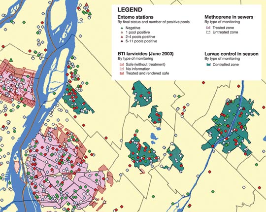
According to Bélanger et al. (2006), adaptation strategies related to heat waves should be geared to monitoring, research, information dissemination and assistance programs. Research would determine what services vulnerable people need to ensure their security during these heat episodes. The key findings should be conveyed to community organizations and front-line workers assigned to civil security.
The study by Vescovi et al. (2005) made it possible to map zones presenting risks for climate warming. An Internet atlas project dealing with certain public health vulnerabilities is being developed on a Quebec-wide scale (Gosselin, 2005) and in more detail for the Island of Montr éal (Kosatsky et al., 2005b).
To combat the UHIE, the use of green roofs or roofs built with high-albedo materials is attracting growing interest, as is the use and availability of public transit in certain regions (Ducas, 2004; Ville de Montr éal, 2005). Certain regional public health administrations are starting to promote these approaches in urban settings.
However, certain supplementary initiatives could be implemented (Giguère and Gosselin, 2006d), such as:
- training health professionals;
- establishing pilot projects for mass education on the subject of personal protection in case of heat waves and to help combat the UHIE; and
- adding economic incentives that encourage initiatives to mitigate the phenomenon of intense heat.
The Quebec government's 2006 to 2012 action plan calls for promoting islands of coolness and training personnel in practices adapted to climate change over the next few years, under the supervision of the Minist ère de la Santé et des Services sociaux.
Ultraviolet rays (UV)
In Quebec, climate change would lengthen the warm season, prompting people to spend more time outdoors and thus be increasingly exposed to ultraviolet (UV) rays (Hill et al., 1992; Diffey, 2004), an impact quantitatively more significant than that arising from the thinning of the ozone layer. The health consequences of overexposure to UV (skin cancer, cataracts, immunosuppressive effect reducing vaccine effectiveness, epidemic development) would increase (World Health Organization, 2003). However, at the Quebec scale as opposed to the Canadian scale, protection against UV rays is not yet properly taken into account (Institut de recherche en sant é du Canada, 2002), despite the 80 000 new cases of skin cancer diagnosed each year in Canada. It is the most common form of cancer in the country (National Cancer Institute of Canada, 2005). Environment Canada issues a UV index that is widely available to the public, and there is a National Sun Safety Committee (Canadian Strategy for Cancer Control, 2001). Adaptation, whether through education or behaviour modification, nevertheless seems a cost-effective measure. In Australia, protecton against the effects of UV rays costs an average of US$0.08 per capita, whereas cancer treatment costs reach US$5.70 per capita (Organisation mondiale de la sant é, 2003). The effect of climate change on this factor is not yet known (Institut de recherche en sant é du Canada, 2002), but preventive measures aimed at creating shade for protection from the sun could prove useful (Government of Quebec, 2006a).
3.5.2. Sensitivity and adaptation of socioeconomic activity
The sensitivity of the Quebec economy to climate change shows significant differences in the quantification of impacts, associated degree of certainty and difficulty in specifying a monetary value. Impacts on the economy can be grouped into several categories:
- The first category includes impacts on infrastructure and buildings. This can mean loss of infrastructure or buildings, maintenance work, greater protection, relocation, reconstruction or redevelopment. In this regard, the Arctic region and the maritime coastline are particularly vulnerable (permafrost thawing, coastal erosion, change in precipitation).
-
The second category covers impacts on economic activity that would change productivity or demand and prices. Long-term economic vulnerability depends on the importance of the sectors affected (positively or negatively) by temperature and precipitation changes. Given the importance of natural resources in its economy (Figure 26), Quebec is more sensitive than some other developed regions of the world where economy is less linked to climate. Indeed, the forest industry, agriculture and hunting and fishing represent 2% of the province's economy ($3.8 billion), and precipitation-dependent hydroelectricity production represented $7.8 billion in 2001. Transformation industries (agri-food, lumber, pulp and paper, metal fabrication) would be affected in terms of availability and cost of raw materials. In addition to resource-based industries, the services sector - such as tourism (restaurants and accommodation, or $4 billion and many jobs) - would likely be affected, either positively or negatively, depending on its adaptation to the changing conditions. Health and medical services would have greater needs faced with the new risks. Other sectors (highway and marine transportation, financial services and insurance) will have to adjust to greater uncertainty and higher claims. In short, a significant share of the Quebec economy would be directly or indirectly affected.
FIGURE 26: Breakdown of Quebec GDP by types of economic sector affected by climate (Ministère des Transports du Québec, 2006c).
- The third category includes impacts on the security, health and well-being of populations, as well as ecosystems, following a change in both mean and extreme values of climate. However, and despite the major role they play in the economy, it is difficult to quantify the real value of these variables other than with indirect measurements.
- Finally, extreme climate events, such as flooding, ice storms, tornadoes and heat waves, represent a set of impacts on the economy that warrant being grouped, as they vary in their duration and magnitude. They affect public security, the integrity of natural ecosystems, the conduct of economic activity and numerous buildings and infrastructure, resulting in high costs (in the billions of dollars) but limited in time.
The south subregion has a diversified economy in which manufacturing and services occupy a large proportion of work production and employment. The resource and rural regions are much more dependent on just one or two activities, including logging, tourism, hunting and fishing, or agriculture. The distribution of climate change impacts would not be uniform across Quebec, and the very survival of certain communities would depend on their capacity to adapt efficiently to the new climate. Climate change is only one aspect of a world in constant evolution. Indeed, Quebec will experience sustained economic growth, doubling its production over 50 years, according to one extrapolation of current trends. Business and technological changes will affect this evolution, making it difficult to forecast the impact of climate change (Ministère des Finances du Québec, 2005).
With respect to the little-studied social dimension, it is likely that the adaptation of Quebec society will require an increased awareness of the phenomenon, such that 1) it would mean relying on an education system systematically embedded in communications aimed at young people (and their parents) on the issue of climate change; 2) this would positively influence the economic and political system, as adaptation measures require action from the public sector; and 3) the media would have an expanded role related to awareness. Media coverage would probably increase with the rising number of victims of climate change. This situation already exists and is expected to grow in importance.
3.5.3. Sensitivity and adaptation of the natural and built environments
Natural environment and ecosystems
Each ecosystem has its own biodiversity that maintains itself dynamically over time, in line with the evolution of environmental parameters (Di Castri and Younes, 1990). Biodiversity takes three forms - genetic diversity, species diversity and diversity of ecosystems (Di Castri and Younes, 1996). A population is a group of individuals of the same species that tries to maintain its numbers from generation to generation. It is the unit on which adaptation pressures are exerted. With each new generation, the individuals must adapt to a set of ecological factors and beget fertile descendants to maintain the species. Ecosystems offer a multitude of goods and services essential to human survival, as shown by certain aboriginal or rural communities that are particularly dependent on these resources (Intergovernmental Panel on Climate Change, 2002).
Climate is the principal factor acting on vegetation structure and productivity and on the global distribution of animal and plant species (Intergovernmental Panel on Climate Change, 2002). Climate change expected for Quebec will probably have locally observable effects on sensitive populations and ecosystems. For certain species, climate change will result in reduced numbers or the disappearance of populations. For others, it will be an opportunity to multiply numbers and extend their distribution range. Climate change will modify the ecological conditions specific to known ecosystems, and even landscapes in the medium and long term (McCarty, 2001; Root and Schneider, 2002; Scott et al., 2002; Walther et al., 2002). These transformations are not deterministic. Living creatures are subject to multiple pressures and climate change is but one part of the equation.
Different issues
The majority of threatened or vulnerable species and ecosystems live in the south subregion (Institut qu ébécois d'aménagement de la forêt feuillue, 2003) and will be affected by the rise in mean temperature and change in the frequency of floods and winter mild spells (Kling et al., 2003). The impact of climate change on the Great Lakes will indirectly alter flooding and mean flows and water levels of the St. Lawrence River; the resulting geomorphological adjustment will affect numerous plant and animal species, some related to wetlands, which already feel the impact of human activity (Mortsch et al., 2000; Morin et al., 2005). The change of St. Lawrence River flows and base levels implies a morphological readjustment of tributary mouths, resulting in the incision and destabilization of beds and banks. Structures on two deltas of Lake Saint-Pierre show the result of the rapid adjustment processes accompanied by a progradation of these features into the river (Boyer et al., 2004).
Plant and animal species in the central subregion have a high resiliency and the communities are ecologically young, arising from the postglacial retreat that ended less than 10 000 years ago. These species, well-adapted to significant annual climate variations and recurring catastrophes and forming large populations distributed over an immense area, will be affected mainly in transition zones (mountainous and riparian areas).
In the maritime subregion, coastal and estuary ecosystems are most at risk from greater erosion, resulting in reduced reproduction and feeding areas for many resident or migratory species (Harvell et al., 2002; Jackson and Mandrak, 2002; Kennedy et al., 2002).
The north subregion will possibly be most affected by the scope of climate change (Flanagan et al., 2003). Ecological changes will occur to the detriment of species adapted to extreme Arctic conditions (Rizzo and Wilken, 1992; Payette et al., 2001). The northward expansion of species typical to the boreal forest will be initiated by existing trees, which produce viable seeds more easily. A certain adaptation of black spruce (Picea mariana) has already been noted (Gamache and Payette, 2004, 2005). However, the migration speed of isotherms will be much faster than that of plants.
River systems and lakes everywhere are particularly sensitive, given their compartmentalization with respect to the migration of fish species (Hauer et al., 1997). Phenological changes in species are also conceivable, as well as an extension of species range limited by mean or minimum temperatures (Edwards and Richardson, 2004).
Sensitivity of species
Living organisms react directly to ecological factors and survive based on their tolerance. Hence, the number of individuals in an ecosystem population is an indicator of their adaptation (Dajoz, 2000) - the higher their tolerance, the better their adaptation, as was shown for fish by Albanese et al. (2004).
An invasive species quickly expands its range in a new ecosystem, either because it is no longer limited by a previously active ecological factor or because it benefits from new conditions created by a disturbance influencing the dominant species of the environment (Bagon et al., 1996).
Phenology is the study of climate-based variations in the periodic phenomena of the plant and animal life cycle, such as dates of migration, triggering of reproductive behaviour, moult, flowering or foliage drop (Budyko, 1974). Several phenological changes have been observed in the twentieth century and this trend will accelerate (Intergovernmental Panel on Climate Change, 2002), triggered by temperature, precipitation, photoperiod or a combination of events. Visser and Both (2005) showed that most species are unable to co-ordinate changes in their phenology optimally with changes in their diet. For example, the migration date triggered by a specific photoperiod will not change with a rise in temperature, but instead based on the behaviour of prey. This absence of co-ordination risks reducing the number of migrating predators (Jones et al., 2003; Strode, 2003).
In the south subregion, species dependent on the flood regime of the St. Lawrence River, including the northern pike (Esox lucius) and perch (Perca flavescens), will be affected (Casselman, 2002; Chu et al., 2005; Brodeur et al., 2006). The approach combining multivariate habitat models with 2-D physical modelling (Morin et al., 2003; Mingelbier et al., 2004, 2005) makes it possible to measure the impact of climate change on habitat areas available to several fish species during critical periods of their life cycle. Water temperature, current speed and water level are key variables for understanding how climate change will affect fish. Already, data indicate a warming of water in certain areas (Hudon, 2004), and the atypical temperatures of summer 2001 produced a massive mortality of carp in the fluvial St. Lawrence River and its tributaries (Mingelbier et al., 2001, Monette et al., 2006). Changes in spring floods will result in a decline in breeding in both marshland birds and waterfowl of the St. Lawrence plain, which include several species at risk (Gigu ère et al., 2005; Lehoux et al., 2005; Desgranges et al., 2006). In the river flood plain, the muskrat is particularly sensitive to winter fluctuations in water level, and changes will profoundly affect it (Ouellet et al., 2005).
In the Arctic region, the polar bear (Ursus maritimus) is dependent on sea ice, while the Arctic fox (Alopex lagopus) has to contend with an extension in the range of the red fox (Vulpes vulpes), which lives off the same food resources (Hersteinsson and MacDonald, 1992; Stirling, 1999; Walther, 2002; Derocher et al., 2004).
Sensitivity of ecosystems
Aquatic ecosystems seem most sensitive to climate change since their biotic communities have difficulty moving from one watershed to another (Hauer et al., 1997). Species such as the Atlantic salmon (Salmo salar) will be disturbed by rising water temperatures that will reach the upper limits of their survival range (Swansberg and El-Jabi, 2001). The new temperature conditions will favour species more tolerant of high temperatures (Figure 27).
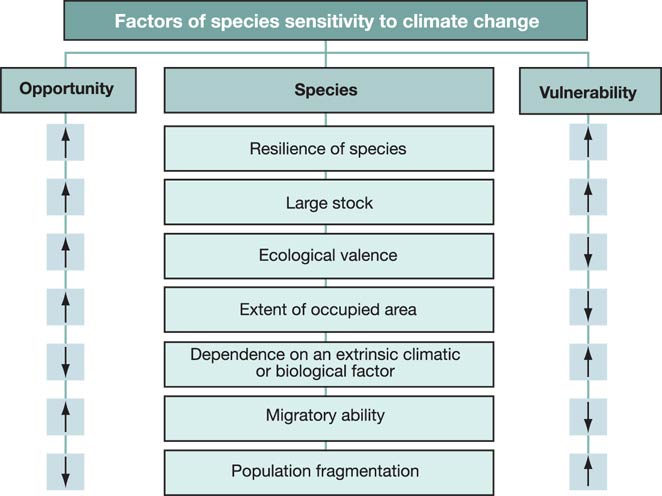
Populations of cold-water fish in the south subregion will be affected by rapid eutrophication and the arrival of sudden, potentially more frequent floods that will result in erosion of the watershed and sediment transport into lakes, a trend already reinforced by human activity such as agriculture, urbanization and logging (Shuter et al., 1998).
Increasing southern lake temperatures will lengthen thermal stratification periods, resulting in anoxic conditions in the hypolimnion during part of the year. Lake trout (Salvelinus namaycus) are sensitive to these two latter stresses (Hesslein et al., 2001). Changes in the flow of the St. Lawrence River will also modify the spatio-temporal distribution of water masses and the typical physical and chemical properties (Frenette et al., 2003, 2006). These changes may affect the nutritive quality of algae (Huggins et al., 2004) and their community structure. The shallower depths should result in more light near the bottom, leading to an increase in the quantity of submerged plants and changes in the properties of dissolved organic matter and particles in the water (Martin et al., 2005a).
Wetlands in all subregions are sensitive to climate change due to the greater variation in annual or inter-annual flood and low water levels associated with violent precipitation or droughts. Turgeon et al. (2005) showed that there exist fundamental links between hydrology and the spatial distribution of major classes of wetlands. Many wildlife species using wetlands will be disturbed, an important issue for the St. Lawrence ecosystem and the marshes of Lake Saint-Pierre (Hudon et al., 2005). Other pressures will also be exerted here, including agriculture and industrial and urban development (Bernier et al., 1998; Robichaud and Drolet, 1998; Jean et al., 2002; Ouranos, 2004), resulting in a fragmentation of habitats (Root and Schneider, 2002).
The forest ecosystems of the central subregion should not experience major changes in their species composition. On the other hand, forest fire frequency and human activity can encourage certain plant associations locally by hastening the process of making forested land available (Gagnon, 1998; Payette, 1999; Coté and Gagnon, 2002; Jasinski and Payette, 2005).
Adaptation strategies
Several actions could be taken to adapt to climate change and reduce the impact on biodiversity:
- Ecosystem resilience:Increasing connectivity and reducing fragmentation between ecosystems seem to be effective pathways for maintaining genetic heterogeneity.
- Monitoring sensitive species:Quebec's biodiversity strategy encouraged each department to establish an action plan and present regular progress reports to the Minist ère du Développement durable, de l'Environnement et des Parcs du Québec (Ministère du Développement durable, de l'Environnement et des Parcs du Québec, 2004b). However, as noted by Gérardin et al. (2002), information on plants and wildlife is incomplete, particularly on the subject of unforested areas (e.g. unproductive forest land, wetlands, subarctic and alpine plants), which can undermine the government authorities' capacity to monitor species sensitive to climate change.
-
Strategy for protected areas: Protected areas, in which some or all human activities are prohibited, serve to ensure the preservation of natural areas or ecosystems that are representative or rare (Figure 28). In contrast to the past, the current approach (Protected Areas Strategy) to selecting new protected areas underlies "a holistic approach of the territory, where the ecosystem is considered as a spatial entity and where the concept of coarse filter appears " (Gérardin et al., 2002, [translation]). However, this method, which places a predominant value on the physical elements of the ecosystem - climate, geology, topography, hydrology, soils - risks weakening the future network of protected areas and its role in protecting species and ecosystems, since the climate and hydrology are destined to change in the medium term. At the national level, Parks Canada developed a strategy that considers climate change in its approach to biodiversity management in existing parks (Wrona et al., 2005). At the municipal and private levels, such mechanisms do not seem to exist. Protected areas could usefully be considered as control areas for natural regions and their evolution, and their management could take future climate change into account. Therefore, in promoting adaptation, it would be advisable to:
- complete the network of protected areas as soon as possible in order to conserve areas representative of each natural region; and
- promote the scientific management of protected areas using inventory, research and monitoring programs to track changes in species and ecosystems under climate change conditions, while maintaining comparison points with adjacent areas.
- Change of harvest rules for live resources: Changes observed in the numbers of certain animals sought by sport and commercial hunters and fishermen will require closer monitoring to avoid additional pressures on fragile species or to slow the expansion of certain species into areas where they were historically absent, thus putting previously resident species in danger.
- Integration of climate change in land management: Génot and Barbault (2005) presented a strategy that describes in detail the issue of preserving biodiversity in a context of climate change. It calls for extending responsibility for monitoring and managing biodiversity to land managers, who could then better understand the issue and better adapt their practices to promote the adaptation of species to the new conditions.
Conclusion: Quebec's changing natural environment
The importance of climate to living organisms needs no further demonstration. Climate change will not result in direct and continuous changes in the composition of ecosystems and the range of species. Instead, its effects will combine with other factors to cause environmental degradation at the local and regional scales. Adapting to climate change will require efforts to reduce the stress imposed on ecosystems. Above all, it will be necessary to develop knowledge about, and monitor, species and ecosystems that are most likely to be vulnerable, in order to adjust management methods to this new reality
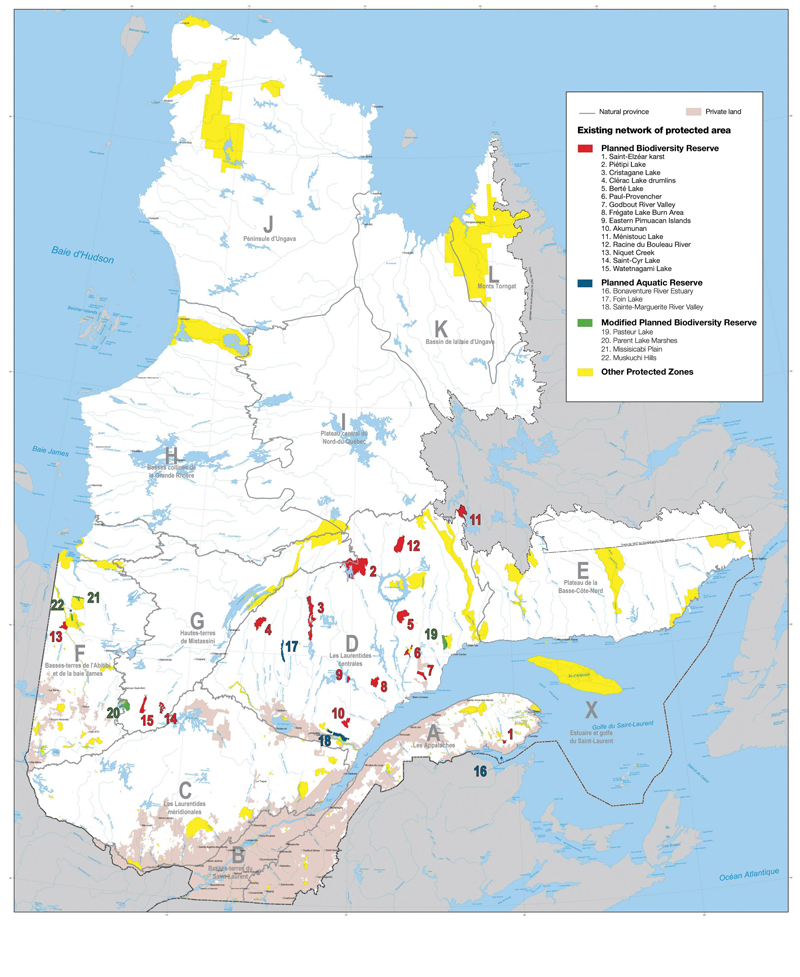
Built environment
The preceding sections dealt with several aspects of the vulnerability of climate-sensitive infrastructure and buildings. The evidence is clear that the vast majority of infrastructure sensitive to climate and built in the last century was designed using statistics on past climate and risks, considered at the time to be representative of future climate conditions. This criterion is questioned throughout this document, raising questions about the security and performance of this infrastructure, particularly in the long term. Fortunately, users and engineers are increasingly aware of this problem (Engineering Institute of Canada, 2006) and adaptive capacity seems to be growing (Infrastructure Canada, 2006). Nevertheless, there will continue to be considerable need for new infrastructure related to socioeconomic development as well as for the refurbishment of a variety of aging infrastructure (Statistics Canada, 2006).
In the long term, the direct and gradual impacts of climate change (see Figure 1) will result in faster wear or loss of performance of different types of infrastructure and buildings. An increase in freeze-thaw cycles tends to accelerate degradation of infrastructure that receives large quantities of abrasives. Road surfaces would buckle more under higher summer temperatures, while poorly adapted buildings would make indoor temperatures risky for vulnerable people. In Quebec, building damage has sometimes been observed when clay soils dry out (Canada Mortgage and Housing Corporation, 1996) following hot and dry summers. In addition, any change in the frequency, duration, intensity and even range of extreme weather events would have significant impact on the vulnerability of the built environment, particularly as such events, depending on the type, have a tendency to involve the hydrosphere (e.g. floods), cryosphere (e.g. ice jam) or lithosphere (e.g. landslide). In fact, there is no shortage of examples in Quebec where low-probability climate events presenting a risk actually happened, affecting the built environment as well as socioeconomic activity, populations and even the natural environment. For example, failing infrastructure contributed significantly to the socioeconomic and environmental impacts of the Saguenay flood in 1996 (Minist ère de la Sécurité publique du Québec, 1996). Damage to the built environment can be caused by a multitude of other failures related to destructive waves, storm surges or tides following the passage of storms (see Section 3.3); landslides caused by heavy saturation or destabilization of the soil (Lebuis et al., 1983); avalanches (Public Security Canada, 2006); excessive precipitation in solid form (Minist ère de la Sécurité publique du Québec, 1999); or even forest fires.
Adaptation of infrastructure and buildings
Such events, as well as those expected in the future, tend to prompt officials to review their operating methods in order to reduce vulnerability (see Table 7). These officials have thus started to:
- revise design criteria and technologies used;
- establish improved emergency measures;
- set up communications networks, while ensuring information circulation and knowledge transfer;
- re-examine land-use planning policies and regulations; and
- develop preventive warning systems.
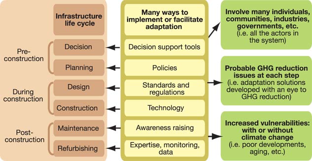
Despite this experience and learning, planned adaptation to minimize the impact of climate change remains rare. Although studies on this subject are few, it would be beneficial to consider various available climate scenarios when designing infrastructure, since infrastructure, once built, has little adaptability and often has a long life cycle. This was done for Confederation Bridge (Canadian Environmental Assessment Agency, 2000). As for highways, which have a shorter life, it is easier to introduce lower cost adaptation solutions as and when they are repaired. For critical infrastructure related to essential services (energy, water, food, health services), it is essential to minimize its vulnerability and introduce mitigating measures in case of failure. This latter consideration may be difficult to achieve at reasonable cost for remote regions.
In fact, adaptation measures can be implemented or introduced at different stages in the life cycle of infrastructure (Figure 29). An analysis of climate risks would support the decision to build or restore critical infrastructure far from a coastal site. It would promote the use of better adapted construction materials, suggest a revision of building criteria and refocus maintenance programs on anticipated problems. These are the types of decisions currently made by engineers to resolve or minimize a problem.
The impact of changing climate-related risks to the built environment requires that 1) better climate scenarios and better impact scenarios be developed (for both the natural and built environment); 2) climate uncertainty be considered in risk analysis at the infrastructure design stage; and 3) new risk tolerance thresholds be integrated, subject to change depending on the needs.
Adaptation under a stationary climate is a known field of expertise sprinkled with success stories, but adaptation under a new, highly variable and uncertain climate is a recent field of expertise for which success stories are yet to come, though likely achievable. Moreover, pertinent adaptation solutions for municipal engineers (e.g. surface retention pond for urban drainage) can become major problems for other factors affected by climate change (e.g. increased breeding of mosquitoes, which can spread the West Nile virus).
| Develop and understand |
Communicate and raise awareness |
Respond and legislate | Apply new or existing technologies | Apply/recommend guidelines or ways of doing things | |
|---|---|---|---|---|---|
| Acquire information and develop expertise | Increase awareness and modify behaviour | Amend laws, regulations and standards | Use techniques, products and materials | Adjust practices and policies | |
| Communities | |||||
| Isolated | Map sensitive zones for the development of infrastructure (1) | Disseminate information on transportation system conditions (2) | Establish land-use planning standards based on sensitive zones (2-3) | Apply techniques to reduce permafrost thawing (4) | Produce a best practices guide for building on permafrost (46) |
| Dependent on natural resources | Identify the best sources of seeds/genotypes (6) | Inform communities on fire risks using the forest fire-weather index (7) | Regulate fishing (opening and closing dates, places, etc.) (8) | Manage fishing by habitat to ensure the viability of resources (8) | Establish a program for economic diversification of communities at risk (9) |
| Coastal | Creation of an integrated scientific project acting in coordination with other participating agencies to meet needs of coastal regions (10) | Hold a simulation exercise to help prepare citizens, municipalities, governments and other actors (11) | Regulate construction in flood-prone areas, zoning and temporary control regulations (12) | Monitor protection structures (13) | Establish integrated management of coastal areas (14) |
| Rural | Learn about varieties used farther to the south (analogs) and adapted to the region (5) | Increase public awareness about saving water during droughts (16) | Establish a program of income stabilization, private insurance and incentives to take climate change into consideration (17) | Extend drip irrigation and the combined technologies of surface drainage and flow (18) | Install effective ventilation systems or sprinklers to cool livestock (19) |
| Urban | Identify lands favourable to allergens and map sources of allergenic emissions (20) | Give information on municipal emergency measures (21-22) | Regulate resistance standards in construction (23) and the Building Code concerning energy (24) | Extend the use of reflective surfaces and coverings (roofs, facade paints, etc.) (25) | Set up local heat-health-heat wave systems (26) |
| Sectors | |||||
| Health | Analyze the link between morbidity-mortality and climate (27-28) | Increase public awareness about smog and heat waves and give advice (29) | Take preventive measures to limit polluting emissions (at the start of the anticyclone) (30) | Launch campaigns to pull up ragweed and plant competing species (20) | Use green roofs or high-albedo materials (12-25). Establish care guides adapted for home care clienteles during extreme events |
| Infrastructure | Analyze aerial photos of the coastline over time and calculate the erosion rate (12) | Set up forecast and early warning systems systems and public education systems (23) | Provincial Civil Protection Act adopted in 2001 following the ice storm crisis of 1998 (31) | Design more resistant buildings (12) or better adapted to the new means (32) | Add 1 m to the Confederation Bridge due to the anticipated rise in sea level (38) |
| Primary sector of the economy | Develop biological methods to control propagation (6) | Increase awareness about harvest and field management adapted to present and anticipated climate conditions (15) | Amend the Forest Act to remove the outdated concept of sustained volume yield (34) | Use species and varieties adapted to different climate conditions (10) | Anticipate by building up one's own financial reserve (35) |
| Terciary sector of the economy | Economic assessment tools (39-36) | Diversify recreational tourism choices to minimize climate risk (37) | Insure against losses due to bad weather and climate by-products (22) | Establish emergency, response and evacuation plans (15) | Raise the design criteria for bridges and culverts by 10% (civil engineering, MTQ) (38) |
| Water | Update the IDF curves (40,41) | Communicate practices to manage rainwater recovery (24) | Implement international agreement on the Great Lakes basin water resources (48) | Rehabilitate degraded resources (22) | Test and review management rules based on various possible climate scenarios (42) |
| Ecosystems | Map ecological niches and assess the changes (43) | Symposium at popular science events (44) | Maintain representative regional plants and wildlife (protected areas) (45) | Restore and preserve wetlands (46) | Protection of species and habitats (47) |
REFERENCES FOR TABLE 7
(1) Ministère des Transports du Québec (2005): Adapter les transports aux changements climatiques; Ministère des Transports du Québec, Dégel du pergélisol, <http://www.mtq.gouv.qc.ca/fr/ministere/environnement/climat/pergelisol.asp>
pergelisol.asp, [accessed May 2, 2007].
(2) Le changement climatique au Québec nordique et ses enjeux, Technical day, May 3, 2005, Montreal, Quebec, <http://www.ouranos.ca/doc/nord_f.html>, [accessed May 2, 2007].
(3) Karstein L. and Domaas, U. (2000): Évaluation des risques d'avalanche au Nunavik et sur la Côte-Nord du Québec, Canada; Geotechnical Institute of Norway, report prepared for the Ministère de la sécurité publique du Québec, 35 p.
(4) Doré G. and Beaulac, I. (2005): Impacts du dégel du pergélisol sur les infrastructures de transport aérien et routier au Nunavik et adaptations - état des connaissances; Faculté des Sciences et de Génie, Université Laval, Québec, Québec, 141 p.
(5) Allard, M., Fortier, R. and Gagnon, O. (2002): Problématique du développement du village de Salluit, Nunavik; Québec, Centre d'études nordiques, Université Laval, Québec, Québec, 121 p.
(6) Beaulieu, J. and Rainville, A. (2005): Adaptation to climate change: genetic variation is both a short-term and a long-term solution; The Forestry Chronicle, v. 81, p. 704 -709.
(7) Environment Canada (1997): The Canada country study: climate impacts and adaptation; < http://www.ec.gc.ca/climate/overview_canada-e.html>, [accessed May 2, 2007].
(8) Irvine, J. (2004): Climate change, adaptation, and 'endangered' salmon in Canada; Proceedings of the Species at Risk 2004 Pathways to Recovery Conference, March 2 -6, 2004, Victoria, British Columbia.
(9) Economic Development Canada (2007): Section Programme développement économique Canada - Régions du Québec; Economic Development Canada,
< http://www.dec-ced.gc.ca/ASP/ProgrammesServices/>
ProgrammesServices_intro.asp, [accessed May 2, 2007].
(10) Ouranos (2007): Programme Environnement maritime; Ouranos,
<http://www.ouranos.ca>, [accessed May 2, 2007].
(11) Ouranos (2007): Changement climatique et usages de l'eau dans le bassin versant de la Châteauguay; Ouranos, < http://www.ouranos.ca/doc/>
chateauguay_fev2004_f.html, [accessed May 2, 2007].
(12) Mehdi, B., Mrena, C. and Douglas, A. (2005): S'adapter aux changements climatiques: une introduction à l'intention des municipalités canadiennes; Climate Change Impacts and Adaptation Research Network (C-CIARN), 35 p.
(13) Morneau, F. (2001): Étude d'impact sur l'environnement : projets de protection des berges le long de la route 132 autour de la p éninsule gaspésienne; main report, Ministère des Transports du Québec, 83 p.
(14) Dubois, J.M., Bernatchez, P., Bouchard, J.-D., Daigneault, B., Cayer, D. and Dugas, S. (2006): Évaluation du risque d'érosion du littoral de la Côte Nord du St-Laurent pour la période de 1996 à 2003; Conférence régionale des élus de la Côte-Nord, report presented to the Comité interministériel sur l'érosion des berges de la Côte-Nord, 291 p., < http://www.crecotenord.qc.ca/component/option,com_docman/task,cat_view/>
gid,33/Itemid,77/, [accessed May 2, 2007].
(15) Bélanger, G., Rochette, P., Castonguay, Y. and Bootsma, A. (2001): Impact des changements climatiques sur les risques de dommages hivernaux aux plantes agricoles p érennes; report submitted to Natural Resources Canada, Climate Change Impacts and Adaptation Program.
(16) Agriculture and Agri-Food Canada (2002): Monitoring drought on the Canadian agricultural landscape; Proceedings of Agrometeorological Workshop, December 9 -10, 2002, CMC Dorval, Quebec; Agriculture and Agri-Food Canada, Prairie Agroclimate Unit/National Agroclimate Information Service.
(17) Smit, B. and Wall, E. (2003): Adaptation to climate change challenges and opportunities: implications and recommendations for the Canadian agri-food sector; Senate standing committee on Forestry and Agriculture, Ottawa, Ontario.
(18) Cyr, J.-F. and Turcotte, R. (2005): Bassin de la rivière Châteauguay: projet du CEHQ et Hydrotel; Ouranos workshop on the Châteauguay River, February 24, 2005.
(19) Lemmen, D.S. and Warren, F.J. (2004): Agriculture; in Climate Change Impacts and Adaptation: A Canadian Perspective; Government of Canada, p. 59 -69, <http://adaptation.nrcan.gc.ca/perspective/index_e.php>, [accessed May 6, 2007].
(20) Garneau, M., Breton, M.C. Guay, F., Fortier, I., Sottile, M.F. and Chaumont, D. (2006): Hausse des concentrations des particules organiques (pollens) caus ée par le changement climatique et ses conséquences sur les maladies respiratoires des populations vulnérables en milieu urbain; Climate Change Action Fund, Project A571, Impacts and Adaptation sub-component, 133 p.,
<http://www.ouranos.ca/doc/Rapports%20finaux/Garneau.pdf>, [accessed May 2, 2007].
(21) Department of Health (2005): Heatwave plan for England reducing harm from protecting health and extreme heat and heatwaves, Edition 2005, 16 p. < http://www.dh.gov.uk/en/Publicationsandstatistics/Publications/>
PublicationsPolicyAndGuidance/DH_4109508, [accessed October 3, 2007].
(22) National observatory for the effects of global warming (2005): Un climat à la dérive : comment s'adapter ?; report presented to the Prime Minister and Parliament of France, < http://www.ecologie.gouv.fr/IMG/pdf/onercdocfrancaise.pdf>, [accessed May 2, 2007].
(23) McBean, G. and Henstra, D. (2003): Climate change, natural hazards and cities; report prepared for Natural Resources Canada by the Institute for Catastrophic Loss Reduction, 18 p.
(24) Kirshen, P., Ruth, M. and Anderson, W. (2005): Integrated impacts of climate change on and adaptation strategies for metropolitan areas: a case study of metropolitan Boston; World Water & Environmental Resources Congress, 2005, Impacts of Global Climate Change, Anchorage, Alaska.
(25) Ducas, S. (2004): Conférence sur le plan d'urbanisme de la Ville de Montréal; 8e Journées annuelles de la santé publique, November 30, 2004.
(26) Ebi, K.L., Teisberg, T.J., Kalkstein, L.S., Robinson, L. and Weiher, R.F. (2004): Heat watch/warning systems save lives - estimated costs and benefits for Philadelphia, 1995-98; Bulletin of American Meteorological Society, v. 85, p. 1067-1073.
(27) Doyon, B., Bélanger, D. and Gosselin, P. (2006): Les impacts des changements climatiques sur la mortalit é dans la province de Québec; Institut national de santé publique du Québec.
(28) Giguère, M. and Gosselin, P. (2006): Impacts des évènements climatiques extrêmes sur la santé : examen des initiatives d'adaptation actuelles au Québec; Institut national de santé publique du Québec, 27 p.
(29) Ministère de la Santé et des Services sociaux (2004): Quand il fait chaud pour mourir; Ministère de la Santé et des Services sociaux du Québec, < http://publications.msss.gouv.qc.ca/>
acrobat/f/documentation/2004/04-269-01.pdf, [accessed May 2, 2007].
(30) National observatory for the effects of global warming (2005): Collectivités locales et changement climatique : êtes-vous prêt ? Un guide pour l'adaptation à l'attention des collectivités locales; National observatory for the effects of global warming, < http://www.ecologie.gouv.fr/>
IMG/pdf/guide_adaptation_2e_ed.pdf, [accessed May 2, 2007].
< http://www2.publicationsduquebec.gouv.qc.ca/>
dynamicSearch/ telecharge.php?type=2&file=/S_2_3/S2_3.htm, [accessed May 2, 2007]. (32) Review of criteria for Agence d'efficacité énergétique projects, pers. comm .
(33) Climate Change Impact and Adaptation Research Network (2003): The road ahead - adapting to climate change in Atlantic Canada; Climate Change Impact and Adaptation Research Network, <http://www.elements.nb.ca/theme/ climate03/cciarn/adapting_f.htm>, [accessed May 2, 2007).
(34) Climate Change Impact and Adaptation Research Network and Ouranos (2005): Proceedings of a meeting on climate change and forestry: impacts and adaptation, Baie-Comeau, Qu ébec, April 20-21, 2005, http://www.mrnfp.gouv.qc.ca/colloque-climat/index.asp, [accessed October 2, 2007).
(35) Bryant, C., Singh, B., Thomassin, P. and Baker, L. (2007): Vulnérabilités et adaptation aux changements climatiques au Québec au niveau de la ferme: leçons tirées de la gestion du risque et de l'adaptation à la variabilité climatique par les agriculteurs; Ouranos, 49 p.,
< http://www.ouranos.ca/doc/Rapports%20finaux/Bryant.pdf>, [accessed May 2, 2007].
(36) United Kingdom climate impacts programme (2007): UKCIP tools: costings methodology, <http://www.ukcip.org.uk/wizard/tools-portfolio/>, [accessed May 2, 2007].
(37) Singh, B., Bryant, C., André, P. and Thouez, J.-P. (2006): Impact et adaptation aux changements climatiques pour les activit és de ski et de golf et l'industrie touristique: le cas du Québec; final report, Ouranos project, <http://www.ouranos.ca/doc/>
Rapports%20finaux/tourisme.pdf, [accessed May 2, 2007].
(38) Ministère des Transports du Québec (2006): presentation given in Sept-Îles on June 2, 2006, Ministère des Transports du Québec.
(39) Dore, M.H.I. and Burton, I. (2001): The costs of adaptation to climate change in Canada: a stratified estimate by sectors and regions; report prepared for Natural Resources Canada, Climate Change Action Fund.
(40) Milton, J., Lam, K.-H., Trentin, S. and Jean-Grégoire, N. (2005): Vers une réduction de la vulnérabilité des municipalités aux phénomènes atmosphériques extrêmes; proceedings of the conference Adapting to Climate Change in Canada 2005: Understanding Risks and Building Capacity, May 4 -7, 2005, Montréal, Quebec, sponsored by the Climate Change Impacts and Adaptation Program, Natural Resources and the Canadian Climate Impacts and Adaptation Research Network (C-CIARN).
(41) Mailhot, A., Rivard, G.,Duchesne, S. and Villeneuve. J.-P. (2007): Impacts et adaptation li és aux changements climatiques en matière de drainage urbain au Québec, INRS-ETE, 144 p.
(42) Fortin, L.G., Turcotte, R., Pugin, S., Cyr, J.F. and Picard, F. (in press): Impact des changements climatiques sur les plans de gestion des r éservoirs Saint-François et Aylmer au Sud du Québec; Canadian Journal of Civil Engineering.
(43) Thuiller, W. (2003): BIOMOD: Optimising predictions of species distributions and projecting potential future shifts under global change; Global Change Biology, v. 9, p. 1353-1362 and Nature, v. 425, p. 914.
(44) Ouranos (2005): Biodiversity and climate change; Workshop of the Association canadienne-fran çaise pour l'avancement des sciences, May 13, 2005, <http://www.ouranos.ca/doc/ACFAS_f.html>, [accessed May 2, 2007].
(45) Gerardin, V. and McKenney, D.I. (2001): Une classification climatique du Québec à partir de modèles de distribution spatiale de données climatiques mensuelles : vers une définition des bioclimats du Québec; Direction du patrimoine écologique et du développement durable, Ministère de l'Environnement du Québec, contribution of the Service de la cartographie écologique.
(46) Klein, J.T., Aston, J., Buckley, E.N., Capobianco, M., Mizutani, N., Nicholls, R.J., Nunn,P.D. and Ragoonaden, S. (2000): Coastal-adaptation technologies; Chapter 15 in Special Report on TechnologyTransfer; Intergovernmental Panel on Climate Change, Geneva, Switzerland.
(47) Wrona, F., Prowse, T., Reist, J., Beamish, R., Gibson, J., Hobbie, J., Jeppesen, E., King, J., Korhola, A., Macdonald, R., Power, M., Skvortsov, V., Keock, G., Vincent, W. and Levesque, L. (2005): Freshwater Arctic ecosystems; Chapter 7 in Arctic Climate Impact Assessment, Cambridge University Press, London, United Kingdom, p. 353 -452.
(48) Great Lakes - St. Lawrence river water resources regional body (2005): Great Lakes-St. Lawrence River Basin Sustainable Water Resources Agreement, <http://www.mddep.gouv.qc.ca/eau/
grandslacs/2005/Entente.pdf>, [accessed May 2, 2007].
Page details
- Date modified: