
Evaluation of Canada’s Legal Boundaries Sub-Program
Table of Contents
- Abbreviations and Acronyms
- Executive Summary
- Recommendations
- Recommendation
- Recommendations and Management Response
- 1.0 Introduction
- 2.0 Evaluation Objectives and Methodology
- 3.0 Findings on the CLB Program Relevance
- 4.0 Findings on the CLB Program Effectiveness
- 5.0 Findings on the CLB Program Efficiency and Economy
- 6.0 Conclusions and Recommendations
- Recommendation
- Annex A: Logic Model
- Annex B: Evaluation Matrix
Abbreviations and Acronyms
| Acronym | Meaning |
|---|---|
| AANDC | Aboriginal Affairs and Northern Development Canada |
| ATR | Additions to Reserves |
| ACLS | Association of Canada Lands Surveyors |
| ADM | Assistant Deputy Minister |
| CBSA | Canada Border Services Agency |
| CCOG | Canadian Council on Geomatics |
| CLS | Canada Lands Surveyors |
| DFATD | Foreign Affairs, Trade and Development Canada |
| DFO | Fisheries and Oceans Canada |
| DG, DGs, DGO | Director(s) General (Office) |
| DOJ | Department of Justice |
| DPR | Departmental Performance Report |
| EA | Evaluation Assessment |
| ESS | Earth Sciences Sector (of Natural Resources Canada) |
| FNPOA | First Nations Property Ownership Act |
| FNLMA | First Nations Land Management Act |
| FNTC | First Nations Tax Commission |
| FPT | Federal/Provincial/Territorial |
| GIS | Geographic Information System |
| HRSDC | Human Resources and Skills Development Canada |
| IBC | International Boundary Commission |
| IBET | Integrated Border Enforcement Teams |
| ILA | Interdepartmental Letter of Agreement |
| ITAB | Indian Taxation Advisory Board |
| MOU | Memorandum of Understanding |
| NALMA | National Aboriginal Lands Managers Association |
| NGOs | Non-Governmental Organizations |
| NRCan | Natural Resources Canada |
| NWT | Northwest Territories |
| NT | Nunavut |
| OGD | Other Government Departments |
| PAA | Program Alignment Architecture |
| PFR | Parcel Fabric Renewal |
| PMF | Performance Measurement Framework |
| PT | Provinces and Territories |
| RCMP | Royal Canadian Mounted Police |
| RPP | Report on Plans and Priorities |
| SED | NRCan’s Strategic Evaluation Division |
| SGB | Surveyor General Branch |
| SO | Strategic Outcome |
| TLE | Treaty Land Entitlement |
| U.S. | United States |
Glossary
The CLB Program touches on many aspects of Aboriginal land claims and First Nation self-government initiatives, as well as the technical nature of legal survey work and land management systems. The following glossary was compiled to help the reader with some terms. Additional information has been footnoted throughout the report.
| ATRFootnote 1 | Conducting surveys (or reviewing existing surveys) is one activity in the process to create new reserves or add land to existing reserves. The ‘Additions to Reserve’ (ATR) Policy was created in 1972 to address this legislative gap and to outline the circumstances under which Canada will favourably consider granting reserve status to land. |
| Boundary | The line of division between two parcels of land. It delimits the extent of parcels in separate ownership or subject to different rights. |
| Canada Lands | Canada Lands are defined in the Canada Lands Surveys Act. In general, these include National Parks, Indian Reserves, and all lands belonging to Her Majesty in right of Canada that are located in the Yukon Territory, the Northwest Territories, Nunavut and Canada's offshore. |
| Canada Lands Survey Records | Canada Lands Survey Records (CLSR) is the repository of all official survey records. This is sometimes referred to as the registry. |
| Canada Lands Survey System | Land surveys are required for the registration of property interests. Currently, the Canada Land Survey System (CLSS) provides the foundation to establish property rights on Canada Lands, by defining, describing and documenting the extent of all land interests. Surveyor General Branch develops standards for customized survey products for land-interest holders.Footnote 2 |
| Dataset | An identifiable collection of dataFootnote 3. In the case of CLB component, this refers to Geographic Information Systems (GIS) data that provides a spatial reference to the survey plans. The Program produces datasets in various formats depending on clients and their needs. |
| Digital Record | Digital records are records created, communicated and maintained by means of computer technology. They may be 'born digital' (created using computer technology) or they may have been converted into digital form from their original format (e.g. scans of paper documents)Footnote 4. In the case of the CLB component, all surveys (e.g. paper reports) have been converted to PDF format (a digital record). |
| FNLM Act | According to the First Nations Land Management Act, a First Nation that wishes to establish a land management regime shall adopt a land code applicable to all land in a Reserve of the First Nation. This land code must include a description of the land that is to be subject to the land code that the Surveyor General may prepare or cause to be prepared or any other description that is, in the Surveyor General’s opinion, sufficient to identify those landsFootnote 5. |
| Land Claims | Since the late 1970’s, the implementation of Comprehensive Land Claims requires land surveys to meet Canada’s obligation with respect to the definition of the extent of land as negotiated between the Aboriginal group, Canada and the province or territory |
| ParcelFootnote 6 | An area of land surveyed or otherwise defined. It includes, but is not limited to, lots, blocks, rights-of-way, land use areas, condominium units, sections, quarter sections, legal subdivisions and concessions |
| SurveyFootnote 7 | In its general sense, the determination of the position of points permanently or temporarily marked on the ground including the keeping of records of all measurements used in the determination. In this manual the term survey often means legal survey. The term legal survey has generally been used when there is a need to clarify that it does not include control, topographical or other types of surveys. See survey, legal. |
| Legal SurveyFootnote 8 | A survey made to define boundaries of parcels of land suitable for the transfer of rights. It includes the preparation of field notes and plans and any examination, approval or confirmation that may be required. See also survey. |
| Survey RecordsFootnote 9 | Survey records may contain survey plans, reports, field notes or other products as specified in the general and/or specific survey instructions. |
| SRIS | The Survey Records Information System (SRIS) is an electronic database that contains the digital records and index to the CLSR. |
| Survey Standards | The CLB component often refers to the General Instructions for Surveys as both regulations and standards. It is also referred to as the manual, E-Manual, e-Edition. There are General Instructions and then specific instructions, or standards, for different types of surveys – e.g., oil and gas, mineral, boundary maintenance, etc. There are a currently 17 standards listed in the General Instructions. |
| Treaty Land Entitlements (TLE) | Surveying the selected lands is a step in the TLE process. Currently, approximately 90% of Treaty Land Entitlement transactions take place in Manitoba and Saskatchewan. Treaty Land Entitlement claims are intended to settle the land debt owed to those First Nations who did not receive all the land they were entitled to under historical treaties signed by the Crown and First Nations. Settlement agreements are negotiated among First Nations, the Government of Canada and provincial/territorial governments (Aboriginal Affairs and Northern Development Canada: http://www.aadnc-aandc.gc.ca/eng/1100100034822/1100100034823). |
| Web Analytics | Web analytics is the measurement, collection, analysis and reporting of internet data for the purposes of understanding and optimizing web usage |
Acknowledgements
The Evaluation Project Team would like to thank those who contributed to this project, particularly, NRCan’s Surveyor General Branch, as well as all those individuals who provided insights and comments crucial to this evaluation report.
The Evaluation Project Team was managed by Olive Kamanyana, with the support of Edmund Wolfe and under the direction of Jennifer Hollington, Head of Evaluation, Gavin Lemieux and Gerry Godsoe, the Strategic Evaluation Division current and former Directors. Evaluation services were provided by TDV Global Inc.
Executive Summary
Natural Resources Canada’s (NRCan) Canada’s Legal Boundaries Sub-Program (CLB Program) supports the Government of Canada by ensuring boundary certainty for Canada. Under the authority of the Canada Lands Survey Act (CLS Act) and more than 20 additional pieces of federal and territorial legislation and the International Boundary Commission Act (IBC Act), the CLB Program ensures boundary certainty through:
- effective boundary surveys of Aboriginal settlement lands to meet Canada's obligations under land claim settlement legislation and treaties;
- statutory registration of legal surveys on Canada Lands (the North, Canada's offshore area, Aboriginal Lands and National Parks), essential to the creation of property parcels;
- the proper maintenance of the Canada-US international boundary for law enforcement, land administration, customs and immigration, and transboundary resource management.
The CLB Program operations are overseen by the Director General of the Surveyor General Branch, who is also the Surveyor General and the Canadian International Boundary Commissioner. The activities for the CLB Program are realized under two components: Canada Lands Boundaries (CLB component) and International Boundary Commission (IBC component). The program is based within NRCan’s Earth Sciences Sector (ESS).
The purpose of the evaluation was to assess the relevance and performance of the CLB Program. This report presents the findings, conclusions and recommendations of the evaluation of the CLB Program over the period 2009-10 to 2012-13. For this evaluation, data collection consisted of gathering information from a document review, a database review, an online survey of Canada Lands Surveyors, and interviews with CLB program management and staff, clients from other government departments, provinces and territories, and Aboriginal organizations.
The evaluation found that there is a continued need for the CLB Program. It is aligned with Government of Canada and NRCan strategic priorities and fulfills an appropriate federal role. The Program has been compliant with legal obligations as defined under the CLS Act and the IBC Act and progress has been made towards the achievement of its immediate, intermediate and ultimate outcomes. The CLB Program has introduced the re-engineering and modernization of its structure and operations towards cost-efficient and economical production of planned outputs.
The specific conclusions and recommendations are:
Relevance
- Canada Lands fall under the jurisdiction of the federal government, which is responsible for its land tenure system. There are requirements for land tenure management on Canada Lands, and the CLB Program supports the land tenure system by providing the Canada Lands Survey system. Under the CLS Act, NRCan has been given the authority and has the expertise to fulfill this responsibility. Consistency with government priorities for the CLB component was confirmed by Budget 2013 where the Federal Government pledged funding for specific claims, First Nations Land Management (FNLM) Regime, Nunavut housing and significant investments in First Nations infrastructure.
- Canada has an international obligation to support the IBC, and the government has a legislated mandate and responsibility to do so. It is one of the basic functions of government to maintain its international boundaries in order to clearly demarcate its jurisdiction. Canada's participation in the IBC fulfills that role. The IBC is well placed within NRCan and, as Canadian Commissioner, the Surveyor General is a member of the Commission where he oversees the work of maintaining an effective boundary line between Canada and the United States.
Effectiveness
- Overall the CLB component is progressing toward achieving its expected outcomes. It is providing expected quality information in a timely fashion that is readily accessible by all stakeholders. Stakeholders view the information as being accurate. However, the evaluation was unable to clearly determine the full scope of use of the information produced by the CLB component.
- The survey standards have not been comprehensively reviewed and updated for 20 years. Although some parts have been updated, some are out of date and there is no ongoing process in place to ensure a regular, comprehensive review of the standards; the CLB management has acknowledged the importance of updating them on a regular basis. Improvements are key to efficient production of legal surveys, maintaining an effective property fabric and processing survey information, i.e., having survey plans efficiently prepared and submitted free of critical errors, and ensuring that parcels are well defined to support land transactions and that parcel datasets are updated daily.
- Boundary markers on the ground demarcate the international boundary. Boundary marker coordinates are available on the IBC website, and digital representation of the boundary is available on Geogratis. Interviews indicated that IBC component information is used by stakeholders including the U.S. Section of the IBC and State Department, and Foreign Affairs, Trade and Development Canada (DFATD). Despite the opportunities for improving the efficiency and effectiveness of the program (e.g., data qualifying and quantifying the users), there is no question that NRCan is meeting its obligations under the law to maintain the integrity of the border.
- Although there is historical collaboration between the Canadian Commissioner and his U.S. counterpart in reaching common agreement on project funding, modernization initiatives, and general decision-making, there is room for improvement in the information products produced by the IBC component. Efforts underway to remove the backlog of Joint Annual Reports and produce new Official Maps of the Boundary and improve the IBC website are representative of these improvements.
Recommendations
- The CLB component requires a more formal and regular process for the review and update of survey standards and regulation, which includes consultation with the program's clients. It is recommended that the Earth Sciences Sector (ESS) develop a comprehensive review plan for standards and regulation within the next 12 months and implement it thereafter.
- It is recommended that ESS finalize the modernization of the IBC component’s production process and the dissemination tools (i.e., website, mapping, and timely annual reporting) within 2 years in order to meet the information needs and expectations of its stakeholders.
Efficiency and Economy
- Overall, the role of technology, and the digitization of the information produced and maintained by the CLB component, is of importance to the achievement of the expected outcomes in an efficient and economical manner. The CLB Program is pursuing a re-engineering and modernization effort, which is an indication that the Department is working towards improved efficiencies (e.g., the modernization has resulted in the integration of IBC and CLB component resources). The funding is generally commensurate with its roles and responsibilities and the activities it undertakes. However, from the CLB Program representatives’ perspectives, current funding constraints indicate an overall tightening of normal operating budget, which creates challenges for maintaining relations with stakeholders (especially First Nations) and human resource planning (including the recruitment and retention of Highly Qualified Personnel).
- The CLB Program is collecting performance information on an ongoing basis. However, the evaluation found that data to link outputs with expected outcomes is not systematically collected. Although there is evidence for service standards on timely access and accuracy of Canada Lands cadastral information, the evaluation found that the CLB component does not actively gather data on the registries’ usage of the survey information that enable transactions. The evaluation relied on the information collected from AANDC’s Indian Lands Registry System (ILRS). The evaluation also relied on findings from the online survey of Canada Lands Surveyors to measure the effectiveness of survey standards and regulations, since such data were not actively collected. For the IBC component, the outputs produced are made available on the website and there is an indication that they are used to support Canada to meet its Treaty obligations by maintaining an effective boundary with the United States. Nonetheless, the lack of data did not enable the evaluation to validate the extent to which the information is used.
Recommendation
- It is recommended that ESS work with the CLB Program stakeholders to enhance data collection, enabling program reporting beyond the production of the outputs and demonstrating the program’s broader achievements. Such improvements will help clarify the broader environmental and economic impacts of the program for external stakeholders as this is not clear at present. In particular, the performance information gathered should be able to support assessment of the following three outcomes:
- Stakeholders have timely access to accurate Canada lands cadastral information to enable the transfer of property rights;
- Canada lands survey standards and regulations are effective; and
- Canada meets its Treaty obligations by maintaining an effective boundary.
Recommendations and Management Response
|
Recommendations |
Management Responsible Responses and Action Plans |
Responsible Official/Sector |
|---|---|---|
|
|
ACCEPTED The Surveyor General will undertake the following actions to ensure that survey standards are maintained on a more formal and regular basis. The CLB component will:
|
ADM, Earth Sciences Sector |
|
|
ACCEPTED The International Boundary Commissioner – Canadian Section will finalize the modernization of the production process and dissemination tools by completing the following required activities over 2014-2016:
The successful completion of these actions will be a result of the interdependent contributions of the Canadian and U.S. sections of the IBC. |
ADM, Earth Sciences Sector |
|
ACCEPTED The Surveyor General will continue to enhance the CLB Program’s data collection, analysis and reporting practices to support strategic decision-making. Processes for metric collection, usage and storage will be documented and implemented by March 2015. |
ADM, Earth Sciences Sector |
1.0 Introduction
1.1 Overview
Natural Resources Canada’s (NRCan) Canada’s Legal Boundaries Sub-Program (CLB Program) supports the Government of Canada by ensuring Canada’s boundary certainty required for well-defined parcels of land used for land management and registration processes on Canada Lands, defining inter-jurisdictional boundaries, and sustaining Canada’s ability to exert its sovereignty and meet its legal obligations. The legal obligations are derived from the Canada Lands Survey Act (CLS Act) and the International Boundary Commission Act (IBC Act). Under the CLS Act, the need for the CLB program to manage survey work on Canada Lands is further described in over 20 pieces of additional legislation, such as the Indian Act and the First Nations Land Management Act, land claim agreements, and the National Parks Act. The IBC Act regulates the international boundary between Canada and the United States as a result of some 26 Treaties, Conventions, Protocols, Decisions and Awards between 1783 and 1925.
The purpose of the evaluation was to assess the relevance and performance of Natural Resources Canada’s (NRCan) Canada’s Legal Boundaries Sub-Program. This report presents the findings, conclusions and recommendations of the evaluation of the CLB Program over the period 2009-10 to 2012-13.
1.2 Program Description
The CLB Program operations are overseen by the Director General of the Surveyor General Branch (within the Earth Sciences Sector), who is also the Surveyor General and the Canadian International Boundary CommissionerFootnote 10. The CLB Program produces products and outcomes to comply with the statutory obligations and interdepartmental commitments in support of boundary certainty for Canada and First Nation Lands. The activities for the CLB Program are realised under two components: Canada Lands Boundaries (CLB component) and International Boundary Commission (IBC component) (A Logic Model is found in Annex A).
1.2.1 Canada Lands Boundaries Component
SurveyingFootnote 11 of Canada Lands is a basic function of government which is in part demonstrated by the first Surveyor General of Canada being appointed in 1872, shortly after Confederation. The CLB component provides stakeholders timely access to accurate Canada Lands cadastral information that enables the transfer of property rights. It also ensures effective Canada Lands survey standards and regulations. The CLB component delivers activities related to managing surveys on Canada Lands, implementing legal survey standards and keeping custody and disseminating survey information through the Canada Lands Survey System (CLSS).
- managing surveys on Canada Lands: article 25 of the Canada Land Survey Act (CLS Act) states that “the Minister shall cause surveys to be made of Canada Lands on the request of a minister of any department of the Government of Canada or a Commissioner administering the Lands and may do so in any other case in which he deems it to be expedient.” The need for other OGDs and the CLB Program for surveys of Canada Lands is further described in the Indian Act and the First Nations Land Management Act (FNLMA), land claim agreements, and the National Parks Act. Over 50 pieces of other legislative instruments highlight responsibilities that fall under the Surveyor General for Canada Lands.Footnote 12
- maintaining and implementing legal survey standards: articles 24(2), 29(3) and 31 of the CLSAct requires that Surveys of Canada Lands be made in accordance with the instructions of the Surveyor General. This involves issuing survey instructionsFootnote 13 to professional land surveyors and reviewing survey returns, thereby ensuring that legal boundaries are portrayed correctly and meet legal requirements.
- keeping custody and disseminating survey information through the Canada Lands Survey System (CLSS): under the article 3(2) of the CLS Act, the Surveyor General has the custody of all the original plans, journals, field notes and other papers connected with completed surveys. The CLB component officially registers this survey information in the Canada Lands Surveys Records (CLSR) and makes them available online.
1.2.2 International Boundary Commission Component
The IBC component supports Canada in the application of the International Boundary Commission Act, 1985 (IBC Act) following Treaties that established the International Boundary Commission commitment to maintain an effective international boundary between Canada and The United States of America.
By maintaining the clear demarcation, regulating work within three metres of the boundary and ensuring that standards for boundary maintenance are developed, the IBC component contributes to the proper maintenance of the boundary between Canada and the United States, thus ensuring that Canada has the boundary certainty required to exert its sovereignty.
1.2.3 Governance, Roles and Responsibilities
For all activities related to the CLB Program, the Director General of Surveyor General Branch reports to the Assistant Deputy Minister (ADM) of the Earth Sciences Sector (ESS). Under the Canada Lands Boundaries component, the SGB Director General acts as the Surveyor General. He is assisted by two Directors who serve as Deputy Surveyors General for Western and the Eastern divisions (see Figure 1). With respect to the International Boundary Commission component, the Surveyor General is the Commissioner and is assisted by the Director, Eastern Canada Division. The Commissioner liaises with Foreign Affairs, Trade and Development Canada (DFATD) for policy-related matters. There is a liaison relationship with DFATD-Director General of the North American Policy Bureau. The Annual Joint Reports of the IBC are submitted to both DFATD and the U.S. State Department. NRCan and DFATD recently finalized a Memorandum of Understanding on the division of responsibilities regarding the Canadian Section of the International Boundary Commission.
Figure 1: CLB Program GovernanceFootnote 14
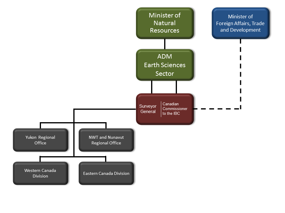
Text version
Figure 1: CLB Program Governance
This diagram is an organization chart that shows the reporting structure from the bottom up. At the bottom are four connected boxes labelled Yukon regional office, Northwest Territories and Nunavut regional office, western Canada division, and eastern Canada division. All boxes are connected to a box above labelled Surveyor General and Canadian Commissioner to the International Boundary Commission. Two solid lines link this box to a box above labelled ADM Earth Sciences Sector. A single solid line links this to a box labelled Minister of Natural Resources. A dashed line links the Surveyor General and Canadian Commissioner to the International Boundary Commission box up to a box beside the Minister of Natural Resources labelled Minister of Foreign Affairs, Trade and Development.
1.3 Resources
The following tables illustrate the CLB Program's budget, averaging $24 million between 2009-10 and 2012-13. During the same period, the number of FTEs averaged 121.7 FTEs with a decline noted in 2012-13. The $21.8 million in CLB component average funding is composed of A-Base (50%), OGD (30%) and C-Base (20%) and has fluctuated within the evaluation period. Most FTEs for this component are A-Base funded (A-Base -81%, OGD-14%, C-Base-5%). IBC component B-baseFootnote 15 funding (average of $2.2 million) and FTEs (average of 11 FTEs) have remained constant over the evaluation period. The activities of the IBC are funded by both Canada and the U.S., and according to the 1925 Treaty of Washington, both parties must provide equal funding.
| 2009-10 | 2010-11 | 2011-12 | 2012-13 | Total | |
|---|---|---|---|---|---|
| CLB | $21.8 | $25.3 | $22.2 | $18.0 | $87.3 |
| IBC | $2.5 | $2.0 | $2.1 | $2.1 | $8.7 |
| Sub-total | $24.3 | $27.3 | $24.3 | $20.1 | $96.0 |
| Fiscal Years | A-Base | C-Base | OGD | Total |
|---|---|---|---|---|
| 2009-10 | $11.3 | $5.3 | $5.2 | $21.8 |
| 2010-11 | $11.1 | $5.9 | $8.3 | $25.3 |
| 2011-12 | $10.7 | $3.8 | $7.7 | $22.2 |
| 2012-13 | $10.7 | $2.2 | $5.1 | $18.0 |
| Total | $43.8 | $17.2 | $26.3 | $87.3 |
| % | 50% | 20% | 30% | 100% |
| 2009-10 | 2010-11 | 2011-12 | 2012-13 | Total | |
|---|---|---|---|---|---|
| Expenditure | |||||
| CLB | $21.25 | $25.2 | $22.1 | $17.7 | $86.25 |
| IBC | $2.5 | $2.0 | $1.9 | $2.1 | $8.5 |
| Sub-total | $23.75 | $27.2 | $24.0 | $19.8 | 94.75 |
| Difference | $0.55 | $0.1 | $0.3 | $0.3* | $1.25 |
| FTEs | |||||
| CLB Component | |||||
| A-base | 91.1 | 91.4 | 88.9 | 85.6 | |
| C-base | 6.3 | 6.2 | 6.0 | 4.0 | |
| OGD | 14.8 | 15.1 | 16.8 | 16.6 | |
| Sub-total | 112.2 | 112.7 | 111.7 | 106.2 | |
| IBC Component | |||||
| B-base | 11.0 | 11.7 | 10.5 | 10.9 | |
| Total | 123.2 | 124.4 | 122.2 | 117.1 | |
2.0 Evaluation Objectives and Methodology
2.1 Evaluation Scope and Objectives
The Treasury Board Policy on Evaluation requires that all Government of Canada’s evaluations be based on an examination of relevance and performance (effectiveness, efficiency, and economy). The objectives of the evaluation were to:
- Assess the relevance and performance of the CLB Program in meeting its objectives; and
- Make recommendations for consideration by NRCan program and senior management.
The following are the evaluation issues that were explored over the period 2009-10 to 2012-13 for the evaluation of the CLB Program.
Relevance
- Is there a continued need for the CLB Program?
- Is the CLB Program aligned with Federal Government of Canada priorities?
- Is the CLB Program consistent with federal roles and responsibilities?
Performance: Effectiveness
- To what extent has CLB Program achieved intended immediate, intermediate and ultimate outcomes?
- Have there been unintended (positive or negative) outcomes?
- Are there clear linkages between outputs and outcomes?
Performance: Efficiency and Economy
- To what extent has the CLB Program managed resources efficiently and economically to produce outputs and progress toward expected outcomes.
2.2 Evaluation Methods and Limitations
2.2.1 Methodologies
For this evaluation, data collection consisted of gathering information from the following sources: document review, database review, interviews, and an online survey of Canada Lands Surveyors.
Document Review
Over 500 documents were identified by the program and through an extensive web-search. Together, these documents provide a comprehensive record of the Program including background information, terms of reference, contracts, financial information, internal and external reports and presentations, program updates and other relevant documents.
Database Review
Based on discussions with CLB Program staff, an initial data collection framework was developed that specified the type of data required, which was then referenced to the respective evaluation issue, sub-question and indicator. The CLB Program staff then collected and submitted the data that is contained in this report. Over 50 files were submitted. The data was extracted from the Survey Record Information System (SRIS), the Project Management Information System (PMIS), Webtrends from the CLB Program websites, server log files, as well as from GeoBase and AANDC’s Indian Land Registry System (ILRS).
Interviews
A total of 46 people have been interviewed for the evaluation. Of the 46 people interviewed 39 were related to the CLB component of the program, and 10 were related to the IBC component of the program. Some people were interviewed for both. Responses were categorized for the purposes of analysis into the following four groups: CLB and IBC Delivery Staff, Other Government Department (OGD) Clients, User Groups (industry, aboriginal organizations, and provinces/territories).
Online Survey of Canada Lands Surveyors
The purpose of the industry survey was to reach out to Canada Lands Surveyors (CLSs) to assess the relevance of the Program to their needs and priorities, as well as its effectiveness in addressing those needs. There are 390 licensed CLSs. The 16 survey questions were developed by the evaluation team with input from the Evaluation Advisory Committee, including the Association of Canada Lands Surveyors (ACLS)Footnote 16. The survey consisted of a rating scale and/or Likert questions with some open questions to collect respondent’s comments.
2.2.2 Limitations and Mitigation Strategies
The following illustrates the limitations in the design and methods for this particular evaluation and mitigation strategies put in place to ensure that the evaluation findings can be used with confidence.
| Limitations | Impact | Mitigation Strategies |
|---|---|---|
| A large volume of documents were not dated or were in draft form | Limited ability to assess their relevance | Use of multiple lines of evidence including document review, key informant interviews and a survey to validate and supplement the findings |
| Some of the data from the database review was not available for the period under evaluation | Difficult generalisation of findings | |
| Some interviewees’ interaction with SGB was limited to certain activities, and therefore could only provide a limited perspective on some evaluation issues | ||
| Only slightly over half of the survey respondents (55.5%) had conducted Canada Lands surveys in the past three years | Approximately 45% of the survey respondents may lack knowledge of the program during this evaluation period | The responses of those who had conducted a Canada Lands survey in the last three years, versus those who had not, were disaggregated for analysis and any differences were noted in the survey technical report |
3.0 Findings on the CLB Program Relevance
The following sections present the evaluation findings, conclusions and recommendations. Evaluation findings are presented by Evaluation Question, and Evaluation Sub-question as per the Evaluation Matrix (see Annex B). Section 3 presents the evaluation findings related to Relevance, Performance Effectiveness, and Performance Efficiency and Economy. Section 4 presents the evaluation's conclusions and recommendations.
3.1 Is there a continuing need for the CLB Program?
Summary:
There is a continuing need to support statutory obligations and interdepartmental commitments to achieve boundary certainty for Canada and FN lands.
From the perspective of documents reviewed and stakeholders’ views, there is an indication for the CLB Component continuing need to clearly define legal boundaries and produce legal descriptions, plans and other cadastral information required for land transactions to occur on Canada Lands. There is an ongoing and continuing need for the IBC component to maintain a clear border between Canada and the U.S. The IBC continues to support stakeholders by properly maintaining, demarcating and mapping the Canada-U.S. boundary. The evaluation found that:
- Broad stakeholder groups in the CLB and IBC components have remained stable since 2009. However, within the CLB component, some of the stakeholder groups have increased in number, particularly Aboriginal communities, and have evolved with respect to their needs for CLB services and products.
- Stakeholders indicate their need for clearly-defined legal boundaries, a robust property system framework, authoritative geographic infrastructure and fundamental geospatial information on Canada’s landmass, without which Canada's economy, environment and standard of living would be negatively impacted.
- Overall, CLB Program activities, outputs and outcomes are consistent with stakeholder needs. Stakeholder needs are continuing, nonetheless:
- there is a growing need with new and improved First Nation self-government initiatives related to land management regimes.
- there is a change in the information needs of stakeholders that impact the timeliness of the production of the products and their accessibility.
CLB Component
Stakeholders, including OGDs and other levels of government, Aboriginal and other Canadian communities, and the private sector, need legal surveys and mapping information to carry out a variety of activities founded on location-based information, such as land transactions, land planning and administration:
- Under the Indian Act, FNLMA and land claim agreements, the need for legal surveys of Canada Lands has continued over time. In some cases, the number of First Nation communities requiring surveys and survey plans has grown, in response to initiatives such as Additions to Reserves and First Nations Land Management as per the First Nation Land Management Act.
- Under the National Parks Act, a Canada Lands survey is required to describe the new park to be created.
- Survey responses of CLSs indicated most (86.5%) believe the need for the Canada Lands survey system still exists, indicating that legal surveys are an important part of Canada’s land tenure system and provide security of the extent of land ownership and use.
The CLB component stakeholders’ ongoing needs can be described as follows:
- OGD Clients, including AANDC, Parks Canada, and others who may have some small levels of engagement with the program at different times (e.g., DFO, EC, Elections Canada, etc.): this stakeholder group's needs for the CLB program information is continuing. For OGD Clients, the outputs of the CLB component (e.g., surveys, legal descriptions, client products, plans and documents) are a necessary input (e.g., a legal description for a National Park, or an ATR) for their own programs. In some cases the CLB outputs are a requirement to fulfill the legislated mandate of their OGD clients, as in the case of Parks Canada for the establishment of national parks (Canada National Park Act), and AANDC in the case of FNLM Act.
- Aboriginal communities and organizations (such as the National Aboriginal Lands Managers Association (NALMA), First Nations Land Advisory Board (LAB), First Nations Tax Commission, and Indian Oil and Gas Canada): This stakeholder group's needs for the CLB program information are continuing. As an example, there are new entrants into the Framework Agreement on First Nations Land Management (FNLM) each year that require survey work to be completed, as do leases on FN lands for oil and gas exploration, pipelines and drilling.
- Industry, such as oil and gas and mining companies: this stakeholder group's needs for the CLB program information continue, for mineral leases in the northern territories, leases on FN lands for oil and gas pipelines, exploration and/or drilling.
- Other stakeholders such as individuals (e.g., surveyors) or organizations who use the information produced by the CLB program (e.g., Territories and Provinces, land planning community, Canada Lands Surveyors, land owners, etc.). These stakeholder groups continue to access CLB program information as they all need to use the CLB information as part of their day-to-day operations.
The information produced by the CLB component addresses stakeholder's needs for the effective management of Canada’s natural resources and lands, including opportunities for collaboration across jurisdictions (i.e. cross-border planning). Some stakeholders stated that the CLB Program services and products are critical to the fulfillment of their own mandate. Even if the stakeholders’ needs have not changed since 2009, the program must continually adjust its outputs’ production and dissemination. There is a continuing stakeholder need for more timely and accessible information which is best addressed through online and electronic mechanisms, as opposed to a more time-consuming and labour-intensive paper-based system.
IBC Component
Stakeholders, including the Canada Border Services Agency (CBSA), Royal Canadian Mounted Police's Integrated Border Enforcement Teams (RCMP-IBET), the general public, landowners, municipalities and provinces require proper maintenance of the Canada - U.S. international boundary for law enforcement, land administration, customs and immigration, and trans-boundary resource management. Clear demarcation of the international boundary, or boundary certainty are continually needed to ensure the clear definition of jurisdictions.
There is a continued need for the IBC to ensure clear demarcation of the international boundary for all stakeholders. Information about the boundary is of particular importance to surveyors, landowners close to the boundary, municipalities and provinces since works (e.g. construction) within three metres of the boundary are regulated. Collaboration and communication; information management; and boundary maintenance, planning and reporting are ongoing needs for all stakeholders to facilitate safety and security, but still be open to tourism and trade on the border between the two countries. Liaison with the U.S. Section, with DFATD and with the U.S. State Department is still essential as it has been throughout history for law enforcement, land administration, customs and immigration, and the management of trans-boundary resources.Footnote 17 An MOU with DFATD that was signed February 20, 2013, establishes “a framework for co-operation clarifying the roles and responsibilities of the Participants on the basis of equality and mutual benefit, and in accordance with the Treaties and mandates of the Participants”.Footnote 18
In respect to the IBC, the evaluation found that the needs are the same, but there is room for diversified and innovative activities towards:
- enhancing demarcation along the Canada-U.S. boundary for greater border security
- developing boundary enhancement plans
- implementation of a geographic information system (GIS) to support IBC operations and enhance information management throughout the organization.
3.2 Is the CLB Program consistent with government priorities and NRCan strategic objectives?
Summary:
The CLB Program is consistent with federal priorities outlined in the 2011 Speech from the Throne with respect to renewing and deepening relationships with Aboriginal communities in a concerted manner, by providing new investments in First Nations Land Management and strengthening U.S.-Canada collaboration to streamline and secure the border. It is also consistent with the Federal Framework for Aboriginal Development; Canada’s Northern Strategy and Devolution; and the 2013 Federal Budget.
Both the CLB and IBC components are aligned to NRCan Strategic Outcome 3, “Canadians have information to manage their lands and natural resources, and are protected from related risks” (SA 3.2.2), under Program 3.2, Landmass Information (PAA 2012-13).
3.2.1 To which federal government priorities is the CLB and IBC linked?
CLB Component:
The CLB component activities, outputs and outcomes are consistent with the following federal government priorities:
- Federal Framework for Aboriginal Economic Development: The Federal Framework for Aboriginal Economic Development is an approach to promote Aboriginal economic development.Footnote 19 The CLB Program is involved in this initiative through expediting ATR and TLE requests, and First Nation Land Management Act activities. The CLB Program, in collaboration with AANDC has undertaken a Survey Pilot Project to test new survey and registry processes in support of land tenure reform.
- Speech from the Throne 2011: The CLB Program is aligned with the 2011 Speech from the Throne with respect to the priority to renew and deepen relationships with Aboriginal communities in a concerted manner, by providing new investments in First Nations Land Management. Within the speech, the Government also reiterated that Canadian sovereignty is tied to strengthening of the North, and made a commitment to continue to exercise leadership in the stewardship of northern lands and waters.Footnote 20
- Canada’s Northern Strategy 2007-11 and Devolution: The CLB Program is aligned with the Northern Strategy and the process of devolution by providing services to ensure boundary certainty between jurisdictions as well as for National Parks and other Canada Lands. The CLB Program continues to work closely with the territorial government to ensure integration of information.Footnote 21
- Federal Budget 2013: In Budget 2013, the Government pledged $54 million to ensure that specific claims are addressed promptly, $9 million to expand the FNLM Regime and, $100 million to support the construction of housing in Nunavut. In addition, over the next 10 years, the Government will make significant investments in First Nations infrastructure (approximately $7 billion) and federal infrastructure (over $10 billion). In order to fulfill the Government’s obligations, it will be imperative that NRCan be able to provide an effective survey approval process to enable timely land transactions.Footnote 22
IBC Component
It is a basic function of government to ensure that Canada has the boundary certainty required to exert its sovereignty. The main activities of the component include maintaining the clear demarcation of the international boundary, ensuring liaison with the U.S. Section, providing legal surveys research, advice and consultation for international boundary issues if they should arise, regulating work within three metres of the boundary, and ensuring that standards for boundary maintenance are developed, maintained and aligned with Treaties.
The work of the IBC is consistent with the Beyond the Borders Action Plan, part of the Economic Action PlanFootnote 23 that addressed "Perimeter Security and Economic Competitiveness". Ensuring a clear demarcation of the boundary is consistent with some of the main components of the Action Plan, including trade facilitation and integrated cross-border law enforcement.
3.2.2 To what strategic departmental objectives and priorities are the CLB and IBC linked?
The CLB Sub-Program (3.2.2) is under Program 3.2, Landmass Information of the 2012-13 Program Alignment Architecture (PAA). It is therefore linked to Strategic Outcome 3, “Canadians have information to manage their lands and natural resources, and are protected from related risks”.
A review of the NRCan 2012-13 PAA indicates that CLB and IBC activities, outputs and outcomes have remained consistent with NRCan’s Strategic Outcome 3, “Canadians have information to manage their lands and natural resources, and are protected from related risks”.
| Level | Expected Results |
|---|---|
| Strategic Outcome 3 | Canadians have information to manage their lands and natural resources, and are protected from related risks |
| Program Activity 3.2: Landmass Information | Public, private sectors and academia use trusted, accurate, Government of Canada geo- information for decision-making and research |
| Sub-Program 3.2.2: Canada’s Legal Boundaries | Statutory obligations and interdepartmental commitments are achieved in support of boundary certainty for Canada and First Nation lands |
3.3 Is there a legitimate and appropriate role for the federal government in the CLB Program?
Summary:
All sources of evidence confirmed that the Government of Canada has a legitimate and appropriate role in the CLB program:
- The role of the Government of Canada in providing the legal survey system for Canada Lands is set forth in federal legislation (CLS Act, Indian Act, FNLM Act, and over 50 pieces of other legislation), and the CLB component is consistent with that federal mandate.
- The role of the Government of Canada in the IBC component is set down in international treaties (i.e., 1908 and 1925 Treaties of Washington ) and federal legislation (i.e., International Boundary Commission Act), making it consistent with that federal mandate.
3.3.1 Should the Government of Canada be involved in providing the legal survey system for Canada Lands?
The evaluation found that the role of the Government of Canada in providing the legal survey system for Canada Lands is set forth in federal legislation, and is consistent with that federal role.
The CLB component supports the Government of Canada through the application of:
- Canada Lands Survey Act 1985
- CLS Act, Article 25, states that “the Minister shall cause surveys to be made of Canada Lands on the request of a minister of any department of the Government of Canada or a Commissioner administering the Lands and may do so in any other case in which he deems it to be expedient”
- Under the CLS Act, the Surveyor General manages surveys and has custody of all original plans, journals, field notes and other papers connected with those surveys.
- Indian Act and First Nations Land Management Act
- Management of survey work on Canada Lands is further described in other legislation such as the Indian Act and the First Nations Land Management Act, land claim agreements, the National Parks Act, and includes stakeholder consultation and advice and contract management.
- Over 50 pieces of other legislation
- Over 50 pieces of other legislative instruments highlight responsibilities that fall under the Surveyor General for Canada Lands (e.g., National Park Boundaries, Inter-provincial/territorial Boundaries, Electoral Boundaries Readjustment Act, etc.)
The majority of interviewees and respondents felt that no other parties could deliver the CLB component activities as Canada Lands are federal jurisdiction and require federal management.
3.3.2 Should the Government of Canada be involved in the IBC?
The evaluation found that the role of the Government of Canada in the IBC component is set forth in international treaties and federal legislation. The commitments concerning the IBC result from various Treaties, Conventions, Protocols, Decisions and Awards between Great Britain and the United States which established the IBC. The current legal authority to the Commission and further mandates were detailed in the 1960 and the 1985 International Boundary Commission Act.
Historical and chronological commitments are as follows:
- 26 Treaties, conventions, Protocols, Decisions and Awards
- The commitments concerning the IBC result from some 26 Treaties, Conventions, Protocols, Decisions and Awards between the 1783 Treaty of Peace (between Great Britain and the United States), the 1908 and 1925 Treaties of Washington between Canada and the United States.
- 1908/25 Treaties of Washington and the International Boundary Commission Act.
- A permanent IBC was established in 1925 with the International Boundary Treaty.
- Further mandates were detailed in the 1960 International Boundary Commission Act.
- A 1993 amendment to article 9 of the 1985 International Boundary Commission Act set out that the Surveyor General is also the Canadian Commissioner.
3.3.3 Are there other parties who could deliver the CLB or IBC aspects that are now federally delivered?
The evaluation found no other parties who have the capacity and/or the mandate to deliver the CLB Program. The CLB Program mandate is to operate on a national scale to a national standard. Canada Lands are federal jurisdiction and as such, it falls under the mandate of the federal government to administer them. A Canada Lands Survey completed/or undertaken in Newfoundland is done according to the same standards as a Canada Lands Survey completed/or undertaken in British Columbia or Nunavut.
Although there is capacity at the provincial level, and growing capacity at the territorial level, their governing legislation is limited to their jurisdiction. Therefore, many key informants or stakeholders felt that there would be a problem with the consistency of standards and information dissemination if the work were to be divided across all provinces and territories.
4.0 Findings on the CLB Program Effectiveness
4.1 To what extent have intended outcomes been achieved as a result of the CLB Program?
| Outcome Level | Outcome | Assessment |
|---|---|---|
| Immediate Outcome CLB Component |
Stakeholders have timely access to accurate Canada lands cadastral information to enable the transfer of property rights | Evidence indicating achievement |
| Immediate Outcome CLB Component |
Effective Canada Lands survey standards and regulations | Evidence indicating partial achievement |
| Immediate Outcome IBC Component |
Canada meets its Treaty obligations by maintaining an effective boundary | Evidence indicating achievement |
| Intermediate Outcome (Sub-program 3.2.2) |
Statutory obligations and interdepartmental commitments are achieved in support of boundary certainty for Canada and First Nation lands | Partial evidence indicating progress towards achievement |
| Ultimate Outcome (Program 3.2) |
Public, private sectors and academia use trusted, accurate, Government of Canada geo-information for decision-making and research | Partial evidence indicating achievement |
The CLB Program issues instructions for surveys, and reviews plans of surveys following a process initiated by Canada Lands Surveyors through a collaborative website platform known as MyCLSS. The MyCLSS website allows surveyors to:
- initiate a survey project;
- request survey instructions;
- use online tools to help in the production of official plans; and
- monitor project status until completion.
Survey information is officially registered. The Surveyor General keeps the custody of all the original plans, journals, field notes and other papers connected with surveys in the Canada Lands Surveys Records (CLSR) to allow parcels to be created on Canada Lands and on fee simple parcels of land in Yukon, Northwest Territories and Nunavut. The digital records of the CLSR are stored in the database referred to as the Survey Record Information System (SRIS). This legal and public repository contains over 100,000 records dating to pre-Confederation Canada. Digital datasets consist of cadastral line and parcel data that is designed and suited for Geographic Information Systems (GIS) application. These datasets are also made available online. Stakeholders can search for and retrieve survey records from SRIS online from the NRCan CLSS website by carrying out a text-based search (Survey Plan search, Survey Project search), by using the CLSS Map Browser, or by using Canada Lands on Google Earth.
Cadastral datasets that can be used in Geographical Information Systems (GIS) are generated by the CLB Program and are widely shared for other purposes, such as geo-political boundaries (accessed via GeoBaseFootnote 24), and the National Framework for Canada Lands Administrative Boundaries (accessed via Geogratis). In addition, CLB datasets with cadastral data and administrative boundaries for Aboriginal Lands are synchronized on a weekly basis with information in the Indian Land Registry System (ILRS)Footnote 25.
Figure 2: CLB Program Process for Managing Canada Lands Survey Records
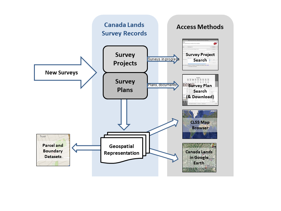
Text version
Figure 2: CLB Program Process for Managing Canada Lands Survey Records
The diagram is a flow chart showing the process running from left to right and top to bottom. The first arrow shaped box is labelled new surveys. This leads to two boxes under the label Canada lands survey records. Box 1, survey projects. Box 2, survey plans. Box 1 points with an arrow labelled surveys in progress, to a box labelled survey project search, under the access methods label. Box 2, survey plans, points with an arrow labelled plans and documents to a box labelled survey plan search and download, under the access methods label. Box 2, survey plans, also points down to a third box labelled geospatial representation, under the Canada Lands Survey Records label. This box points left to a box labelled parcel and boundary datasets, and right to two separate boxes under the access methods label, one box Canada Lands Survey System Map Browser, and the other box Canada Lands in Google Earth.
4.1.1 To what extent do stakeholders have timely access to Canada Lands cadastral information?
There is evidence indicating that stakeholders have timely access to Canada Lands cadastral information
The CLB component has developed service standards related to the monitoring and review of official survey documents submitted to NRCan for public recording. Over the period of the evaluation, the time for the review of surveys has reduced from 94 days to 50 days (47%). The CLB component is only responsible for survey plans during certain parts of the review process. The rest of the time, the plan is under the review of the external client. Sufficient baseline data and software would help to isolate the time in CLB control. There is the possibility to gather this data from the processes developed through the introduction of digital signatures, which is expected to be able to distinguish between the various “owners” of the processes.
The Canada Lands Survey Records are available online 24/7 and the online parcel datasets are updated daily. Overall, the evaluation found that the stakeholders for the CLB component have timely access to survey records, which are all available on-line and that further areas for improvement (e.g., digital signatures) have been identified.
CLB service standards with respect to processing survey information are developed, monitored, changed and complied with:
The program and the ACLS worked together over a two-year timeframe to design and launch the MyCLSS Web application in March 2011. The goal of the MyCLSS Web application is to modernize and integrate the survey processes of NRCan and the ACLS in a manner that is consistent with the Canada Lands Surveys Act and Canada Lands Surveyors Act. This Web application introduced a change in culture of the monitoring and review of official survey documents submitted to NRCan for public recording and the practice review of each land surveyor and survey firm under the responsibility of the ACLS.
The introduction of MyCLSS has also allowed development and monitoring of new service standards, and facilitated the monitoring of other service standards through the support software for MyCLSS.Footnote 26 As a result, the CLB Program has developed four key service standards:Footnote 27
- Plan reviews completed by the CLB Program within 20 calendar days (target >95%).
- Plans submitted to the CLB Program free of critical errors (target>95%).
- Canada lands Survey Records are available online 24/7 (target 100%).
- Online parcel datasets are updated daily (target 100%).
Service Standard #1: Plan reviews completed by CLB Program within 20 calendar days (target > 95%)
The completion of survey plan reviews is difficult for the system to measure as the CLB is only responsible for survey plans during certain parts of the review process. The rest of the time, the plan is under the review of the external client. Rectifying this issue would require sufficient baseline data and significant effort in software development where CLB Program time would need to be isolated. The CLB Program intends to gather this data from the processes developed through the introduction of digital signatures, which is expected to be able to distinguish between the various “owners” of the processes.
The CLB Program is monitoring this service standard. The time for the review of surveys has reduced from 94 days to 50 days (a reduction of 44 days or 47%), from when returns are received to when they are recorded in the CLSR.Footnote 28
Service Standard #3: Canada Lands Survey Records available online 24/7 (target 100%)
Taking the external access to CLSR information as the main indicator for availability (as opposed to internal access for staff), for three years in the last five years, the information has been available 100% of the time on business days. For two years out of five it has been 100% available all the time. Overall, the CLSR information has never been available for less than 99.2% of the time.Footnote 29
Service Standard #4: Online parcel datasets updated daily (target 100%)
The datasets produced by the program are geospatial referenced information that is used by other departments and agencies, land registries, land developers, First Nations, other geospatial web portals (such as GeoBase, Geogratis) and other users to fulfill their needs. These data sets are made available on the NRCan websiteFootnote 30. Should the dissemination process for any of these datasets fail, then one-day old data is made available instead of the latest data. Each workday a new dataset with all the final integrated parcels available at the time is prepared for distribution. On average, the CLB Program updated datasets daily between 97.7% and 99.7% of the time.Footnote 31
4.1.2 To what extent do stakeholders have the correct Canada Lands cadastral survey information?
There is evidence indicating that stakeholders have the correct Canada Lands cadastral survey information. Progress was made by the CLB component to meet service standards and quality control measures. From 2009 to 2012, the percentage of submissions from land surveyors returned in need of corrections was reduced from 70% to 27%. Stakeholders are confident that the information provided is correct.
Service Standard #2 Plans submitted to the CLB Program free of critical errors (target>95%).
Plans submitted to CLB free of critical issues, is directly related to the quality control process of the survey information. When MyCLSS was initiated in 2011, new service standards were set and the CLB Program targeted the portion of plans with critical errors at less than 5%. Since then, the CLB Program and Association of Canada Lands Surveyors (ACLS) have both been reviewing the critical issues with a large number of occurrences and taking corrective actions. To illustrate this collaborative work, an ACLS CommuniqueFootnote 32 in March 2013 requested its members to pay special attention to three areas of Canada Lands surveys that had experienced higher than average errors.
The vast majority of CLB stakeholders believe that the survey information is accurate. The Canada Lands cadastral survey information that is available to stakeholders is the latest official information
4.1.3 To what extent does the survey information enable the transfer of property rights?
There is some evidence indicating that the survey information enables the transfer of property rights.
Surveys are a fundamental requirement for any land transaction but not a sufficient condition for land transaction to occur. All land transactions occurring on Canada Lands use Canada Lands survey information. Although the CLB information is used by some 20 registries, the CLB component does not actively gather performance data on the registries’ usage of this survey information to enable transactions. The evaluation relied on the information collected from the AANDC’s Indian Land Registry (ILRS) which indicated a significant number of land transactions occurring on Canada Lands.
The role of the CLB component and specifically the outputs it produces, are an essential but not a sufficient condition for a land transaction to occur. Surveys are one requirement of a land management system, and in order to measure the end result of the CLB Program, it is necessary to look at what happens after a survey plan is approved. The role of the survey system is to define the extent and location of interests (rights) and if required, demarcate those limits (boundaries) on the ground. This defines the parcel of land.
The role of a land registry system is to assign rights to those defined locations. Land transactions are an exchange of rights and are captured by the land registries, such as the AANDC’s Indian Land Registry Footnote 33. For the latter, all land transactions that occur under the responsibility of AANDC are based on an approved survey plan from the CLB Program that is registered in the CLSR. A survey plan can create many parcels and a parcel can be used to register many land transactions (e.g., one parcel may be bought and sold several times, or bought then leased). In this sense a legal survey is a multi-generational investment.
The ILRS is updated on a weekly basis with datasets from the CLSR. The CLB Program also interacts with land title registries in all provinces and territories as well as with specialised registries, such as for minerals and oil and gas, for the same purposes. The following table presents the number of parcels created by surveys, during the evaluation period.
| Output | 2009-2010 | 2010-2011 | 2011-2012 | 2012-13 |
|---|---|---|---|---|
| Parcels created in cadastral datasetFootnote 34 | 4,773 | 5,840 | 6,339 | 9,469 |
Information obtained from the ILRS revealed that there were 56,936 land transactions registered in the ILRS between 2009 and 2013 based on Canada Lands surveys. However, the evaluation was unable to clearly make associations between the above created parcels and the ILRS land transactions in the same period as these transactions may have used surveys that may have been completed any time in the past, going as far back as 100 years. In addition, the same survey information can be used many times to enable land transactions.
For the purpose of illustrating linkages between the survey plans registered in the ILRS and land transactions, the evaluation found a total of 6,106 land transactions registered in the ILRS based on plans that were recorded in the CLSR between 2009 and 2013.
4.1.4 To what extent are Canada Lands survey standards and regulations effective?
There is evidence indicating progress on the effectiveness of the Canada Lands survey standards and regulations. Survey findings indicated (almost 65% of respondents) that the current standards and regulations are effective. OGD Clients and Provinces/Territories have identified areas for improvements to meet unique client needs (e.g., considering the realities of surveying in the north and in National Parks), and technology and regulatory changes in the working environment. The CLB component does not actively collect data to measure the effectiveness of survey standards and regulations. However, they have acknowledged that the standards need to be reviewed and revised.
Over the years, the CLB Program has developed and maintained survey standards (e.g., survey standards for mineral claims in the Yukon, oil and gas surveys on Indian reserves, official surveys, boundary maintenance surveys, etc.). These are all outlined in the Manual of Instructions for the Survey of Canada Lands.
There have been ongoing updates and additions to the Manual. From interviewees and document review, the evaluation identified a range of opportunities for modernizing the cadastral foundation for Canada Lands and related improvements for the Manual of Instructions, including parcel fabric renewal; electronic submission; mining regulation amendments; condominium and strata title surveying processes on Reserves; enhanced links between the CLSR and existing registries of rights; surveying in the North, and linking the CLSR and First Nations title registries.
The CLB component has acknowledged that the standards need a comprehensive review which is expected in March 2014. The CLB Program is reaching out to its stakeholders, including the ACLS. Information and requests for comments have been posted on the ACLS website to consult its members and six members participated in a standards workshop in October 2013. Discussions have also been held with provinces and territories at the Canadian Council on Geomatics (CCOG). Many smaller groups of land surveyors have also been consulted at the Annual General Meetings of the provincial land survey associations.
Most stakeholders believe that the standards are effective, although, as noted, there were areas of improvement that were identified. The online survey of Canada Land surveyors indicated that almost 65% of respondents indicated that this outcome was completely achieved or mostly achieved.
4.1.5 To what extent does Canada meet its Treaty obligations by maintaining an effective boundary with the United States?
There is evidence indicating that Canada meets its Treaty obligations by maintaining an effective boundary with the United States.
The 15-year maintenance plan was adopted in 2005; however the U.S. section was only funded to the levels required in the plan in 2010, resulting in a need to revise the 15-year plan. It is projected that the backlog of projects will be eliminated by 2014, at which time the IBC will be back on track with the original 15-year maintenance plan.
The boundary between Canada and United States, almost 9,000 km in length, came into being through 20 treaties, conventions, protocols, decisions and awards between 1783 and 1925. The IBC, consisting of one Commissioner from each of Canada and the United States, was established by treaty in 1925 and has the mandate to maintain the boundary.
The activities under the IBC contribute to the proper maintenance of the boundary between Canada and the United States. The main activities consist of maintaining the clear demarcation of the International Boundary; ensuring liaison with the U.S. Section, providing legal surveys research; advising and consulting on international boundary issues when they arise; regulating work within three metres of the boundary; and ensuring that standards for boundary maintenance are developed, maintained and aligned with Treaties.
Boundary maintenance includes proper monument placement and maintenance as well as clearing of treed vistas. In 2004, a revised maintenance plan (consisting of 5- and 15-year forecasts) was developed by both Commissioners to better address the priorities of the IBC. The 15-year forecast addressed recurring routine maintenance (brush clearing, monument maintenance and surveying). The 5-year plan focused on projects that had fallen behind.Footnote 35 In 2010-2011, a total of 182 km of boundary vista was cleared along the southern border of the province of Quebec by the Canadian section. A total of 200 monuments were inspected, 4 renewed and 7 new monuments set, and 103 monuments were resurveyed. Eight new official maps were signed by the Canadian and U.S. Commissioners.
4.1.6 To what extent are statutory obligations and interdepartmental commitments achieved in support of boundary certainty for Canada and First Nation lands?
The evaluation collected partial evidence indicating progress towards achievement of the statutory obligations and interdepartmental commitments in support of boundary certainty for Canada and First Nation lands.
Statutory obligations and interdepartmental commitments are being met by the CLB Component through ILAs with OGDs (or other mechanisms e.g., TB submissions) regarding managing and approving survey plans and providing boundary opinions in the context of ATR and TLE, FNLMA, and Northern Land claims. For the IBC component, statutory obligations and interdepartmental commitments are being met through Annual Reports which have been produced by the IBC Commission up to 2011 and the proper maintenance of an effective boundary line between Canada and the United States. Recently an MOU with DFATD was established to define IBC responsibilities as including collaborating with the Department of Justice, law enforcement and border agencies and reporting annually.
CLB Component
The CLB Program's statutory obligations are defined in the 1985 CLS Act, which states that the authority for NRCan "to cause surveys on Canada Lands on the request of a minister of any department of the Government of Canada or a Commissioner administering the Lands”. This is part of the CLB Program mandate. A total of 6,783 survey plans were registered during period 2009-10 to 2013-14.Footnote 36
In response to requests for services from other government departments, the CLB component has entered into a number of interdepartmental commitments which are formalized into Interdepartmental Letters of Agreement (ILAs). Approximately 40 ILAs are entered into each year with OGDs, totaling $27.7M from 2009-10 to 2012-13, or approximately 30% of program funding Footnote 37.
Other interdepartmental commitments are outlined in Land Claim agreements for which the CLB component has responsibilities for defining the boundaries. The program receives C-based funding to fulfill these interdepartmental commitments (approximately 20% of funding).
Through services offered by ILAs, the CLB component was involved in:
- 1275 ATR projects in 7 years (from January 1, 2005 to January 1, 2012)
- By the end of 2012-13 approximately 8,450 sq. km of TLE were completed out of a total 14,678 that has been identified as the total TLE obligation, or 57.5% (54% at end of 2009-10).
- There were 187 Legal Descriptions Reports (boundary opinions), pursuant to the FNLMA, either active or completed between 2006 and 2009. Another 21 were completed in 2009-2010; 40 in 2010-11; and 10 in 2011-2012; and 10 in 2012-13.
In some cases, there may be delays that require work for ILAs to continue into the next fiscal year. Delays were due to various factors such as delay in receiving funds, and delay in finalizing contracting for surveying.
Through funding provided in Land Claim agreements:
- As of January 2010, Northern Land claims area surveyed was as follows:
- Yukon 30,216 sq. km. (6% of Yukon);
- NWT 187,703 sq. km. ( 14% of NWT);
- Nunavut 352,191 sq. km (r 17% of Nunavut).
- Between 2010-11 and 2012-13 the program surveyed 403 km of boundary for the Tlicho land claim agreement.
IBC Component
As outlined in international treaties and the IBC Act, the IBC component supports Canada’s response to its statutory and treaty obligations regarding clearing and demarcating the international boundary between Canada and U.S. Maintaining a cleared, demarcated boundary, regulating works within three metres of the boundary and related legal survey research and liaison with stakeholders is being carried out and is still ongoing. Activities related specifically to border security have included support to the Integrated Border Enforcement Teams (IBET) that falls under the RCMP. In addition, the RCMP, U.S. and Canadian Customs have requested IBC to mark a number of transboundary waters, agreed by the Commissioners. Further work related to the production of Joint Annual Reports has been partially met. Joint Annual Reports up to 2011 have been produced by the IBC Commission.
It is under the IBC component that a Memorandum of Understanding (MoU) was signed between NRCan and DFATD in 2013. The MoU clarified the roles and responsibilities of the Participants on the basis of equality and mutual benefit, and in accordance with the Treaties and mandates of the Participants. The MoU outlines IBC’s responsibilities in respect to its statutory obligations as well as its role in collaborating with the Department of Justice (DOJ), law enforcement and border agencies.
4.1.7 To what extent do public, private sectors and academia use trusted, accurate Government of Canada geo-information for decision-making and research?
The evaluation collected partial evidence indicating progress towards achievement of the use of trusted, accurate Government of Canada geo-information for decision-making and research by the public, private sectors and academia.
Stakeholders’ views indicate that geo-information produced by the CLB component is being used. Statistics gathered by the CLB component show that geo-information products are accessed. The IBC’s boundary monuments and vista clearing result in its main output - a maintained visible boundary on the ground. While the IBC Component information is available on the IBC website and GeogratisFootnote 38, interviewees have raised concerns about the quality and timeliness of the IBC information products, such as maps, websites and reports.
For both components, the evaluation found limited performance information that identifies the type of users and how they use the information. Information obtained from the ILRS revealed that there were 56,936 land transactions registered in the ILRS between 2009 and 2013 based on Canada Lands surveys.
CLB Component
The information produced by the program is widely disseminated. All stakeholders have indicated their use of CLB component information. In the online survey, 80% of respondents indicated that publication and dissemination of information is a “very useful” or “quite useful” activity. All stakeholders stated that they use the information provided by the CLB component. The information they use may be the geospatial data, or the actual surveys. Some departments use this information on a daily basis (e.g. the FNLM within AANDC). The information is trusted and stakeholders report a high degree of usage. The information produced by the CLB component is provided to all land registries.
All CLB component geo-information products are available on-line. Web analyticsFootnote 39 indicate significant use of geo-information: on average, there are more than 70,000 visits per year to the website by users to access geo-information; 65,000 documents are downloads per month; and datasets are downloaded on average 3,000 times per month.
The program does capture some basic information on those who are sending information requests. They are categorized by province/territory, private sector, other government department, or AANDC. However, there is limited means by which the program can systematically capture the type of user that is accessing the online information. It is the program's understanding that in order to capture that information, it would be necessary for users to register an account, making the data less open and accessible. The program has not planned to introduce an account registration process to access its data.
IBC Component
IBC component information is used by stakeholders including the U.S. Section of the IBC and State Department, DFATD, organizations in charge of Canadian and U.S. border services (e.g., CBSA, U.S. Border Control, IBET, RCMP), municipalities, provinces, surveyors, landowners and the general public.
Boundary marker coordinates are available on the IBC website, and digital representation of the boundary is available on Geogratis. A new website is under construction, but there is no timetable for website redesign.
A key missing piece of information is the official digital representation of the boundary. This delay has been caused by a delay in obtaining data from the U.S. In addition, maps of the boundary are out-of-date, however, a project for the maintenance of the GIS and mapping information holdings has been identified as a priority and will be an added as a yearly cost to the 15-year maintenance plan.
4.2 Have there been unintended (positive or negative) outcomes?
The Evaluation identified no significant unintended (positive or negative) outcomes for the CLB and IBC components. However, facilitating and hindering factors have been identified for the CLB component:
- Facilitating included technological innovation in response to stakeholder needs, for example, the MyCLSS website.
- Hindering factors have included difficulty in attracting and recruiting Highly Qualified Personnel (HQPs), travel restrictions and long contracting processes.
There are some external factors identified by CLB program delivery interviewees that can hinder the delivery of the program.
Program managers and other stakeholders interviewed, stated that since 50% of the program’s budget comes from external sources, and can fluctuate from year to year; it can make human resource planning difficult. Compounding the challenges raised in HR planning caused by fluctuations in funding, is the fact that the surveyor population is aging (average age >55 years old), and it is difficult to compete with the private sector compensation packages. These three factors make human resource issues a major challenge for the program.
One other factor mentioned by interviewees is the expectations from stakeholders that the program will maintain high standards in respect to timely dissemination and accessibility of data. At the same time the IT infrastructure in the Government of Canada is moving to Shared Services Canada (SSC), and out of control of the program.
4.3 Are there clear linkages between outputs and outcomes?
The evaluation found linkages between CLB and IBC components’ outputs and immediate outcomes. However, there was limited evidence to determine the complete range of users and to determine the extent to which the information is used for decision making. Nonetheless interviewees revealed that the program staff and some stakeholders used the produced outputs to make decisions at the operational level. Furthermore, some linkages were found between CLB program outputs and intermediate/ultimate outcomes, such as the 6,106 land transactions registered in the ILRS that were based on program outputs recorded between 2009 and 2013.
CLB Component
All data sources confirmed that the production of outputs such as standards, survey instructions, maintenance of the CLSR, and outputs associated with ILAs and land claim agreements results in the timely and accessible information that facilitates land transfers on Canada Lands.
The CLB component outputs are accessible, accurate, and known to stakeholders. There is clear evidence of information management platforms (e.g., Survey Record Information System (SRIS)), that facilitate the accessibility of geo-information products.
The production of the outputs has contributed to statutory obligations and interdepartmental commitments being met. Evidence was found that the survey information enables land transactions. Any land transaction involving Canada Lands must be based on a legal description and that legal description must be approved by the Surveyor General and be registered in the CLSR. During the evaluation period 56,936 land transactions were registered in the Indian Land Registry System (ILRS) that were based on Canada Lands surveys.
However, the evaluation has not found strong evidence to determine the complete range of users, as users include anyone accessing CLB component information and outputs (e.g., plans, datasets, standards, geo-information products such as map browsers), nor to determine the extent to which the information is used for research or decision making. Even if there is some evidence that the CLB component used the produced outputs to make progress to the achievement of the ultimate outcome, the lack of baseline and ongoing performance data did not enable the evaluation to the extent to which the information is used and for which purpose.
IBC Component
The Canadian section’s responsibilities for boundary maintenance including refurbishment of monuments are on track regarding the 15 year plan. Statutory obligations and interdepartmental commitments are being met.
The outputs of the IBC component are maintenance plans, boundary monuments and markers, cleared boundary lines, letters of permission or restriction, official treaty maps, data sets, and Joint Annual Reports.
The outputs produced by the program are available on its website, e.g., boundary marker coordinates are available on the IBC website, and digital representation of the boundary is available on Geogratis. Concerns about the quality and timeliness of the information that is provided has been noted in this evaluation.
The evaluation has also demonstrated that by producing these outputs, the IBC component is meeting its statutory obligations and interdepartmental commitments. The interviews indicated that IBC component information (datasets, maps, annual reports) is used by stakeholders (including the U.S. Section of the IBC and State Department, DFATD, organizations in charge of Canadian and U.S. border services (e.g., CBSA, U.S. Border Control, RCMP-IBET), municipalities, provinces, surveyors, landowners and the general public) for decision making at the level of operations. However, the lack of baseline and ongoing performance data did not enable the evaluation to the extent to which the information is used and for which purpose.
5.0 Findings on the CLB Program Efficiency and Economy
5.1 Evaluation Question 7: Is the CLB Program the most economic and efficient means of achieving outputs and progress toward outcomes?
All lines of evidence have indicated that the re-engineering and modernization initiative of the CLB Program has been undertaken with a view to increase efficiency and reduce costs. The initiative is still being implemented, but indications are that it continues to progress towards improved efficiency.
5.1.1 What is the difference between planned and actual spending? What explains this difference, if any?
There has been no significant difference between planned and actual spending.
A total of $1.25 million over four years out of a total budget of $96 million was under-spent (1.3%). The CLB Program funding indicated fluctuations during the evaluation period because of the instability in C-base and OGD funding. Even if unstable, the C-base funding is generally more predictable as it is dedicated funding for a fixed period of time. Despite the discussion with OGDs regarding their upcoming needs, OGD funding is only finalized and known during each fiscal year, making it harder to predict from one year to the next.
Even though the CLB Program budget indicates no significant difference between planned and actual spending in either the CLB or IBC components, the evaluation found financial fluctuation though the evaluation period.
As Table 6 illustrates, the CLB Program's budget has decreased from a high of $27.3 million in 2010-11 to $20.1 million in 2012-13. The CLB component overall funding has decreased from a high of $25.3M in 2010-11 to $18M in 2012-13. It is estimated to drop even further to approximately $16.3M in 2013-14Footnote 40. The fluctuation in CLB component funding is raised within the body of the evaluation report (see Section 1.3). IBC component funding is B-baseFootnote 41 and has remained constant over the evaluation period. The activities of the IBC are funded by both Canada and the U.S., and according to the Treaty, both parties must provide equal funding. Slightly higher levels of funding were recorded in 2009-10, which was the last year of augmented funding to catch up on a backlog of maintenance projects.
| 2009-10 | 2010-11 | 2011-12 | 2012-13 | Total | |
|---|---|---|---|---|---|
| Total Funding Sources | |||||
| CLB | $21.8 | $25.3 | $22.2 | $18.0 | $87.3 |
| IBC | $2.5 | $2.0 | $2.1 | $2.1 | $8.7 |
| Sub-total | $24.3 | $27.3 | $24.3 | $20.1 | $96.0 |
The CLB Program expenditures are almost equally spent between Salaries and O&M expenses. The expenditures fluctuated following the level of funding. Overall full-time equivalents (FTEs) engaged in the CLB Program ranged from a high of 124 in 2010-11 to a low of 117 in 2012-13, with further decreases estimated for 2013-14.
| 2009-10 | 2010-11 | 2011-12 | 2012-13 | Total | |
|---|---|---|---|---|---|
| Total Expenditure | |||||
| CLB | $21.25 | $25.2 | $22.1 | $17.7 | $86.25 |
| IBC | $2.5 | $2.0 | $1.9 | $2.1 | $8.5 |
| Sub-total | $23.75 | $27.2 | $24.0 | $19.8 | 94.75 |
| Difference | $0.55 | $0.1 | $0.3 | $0.3* | $1.25 |
| FTEs | 123.2 | 124.4 | 122.2 | 117.1 | |
Table 8 provides more details on the CLB Component expenditure during the evaluation period. Both C-base and OGD funding fluctuate from year to year. C-base funding fluctuates, but is generally more predictable as it is dedicated funding for a fixed period of time. OGD funding however is only finalized and known during each fiscal year. While discussion does proceed with OGDs regarding their upcoming needs, the funding does fluctuate and is harder to predict from one year to the next.
Within the context of fluctuating and unpredictable funding, the CLB component’s A-base funding has been reduced by $0.7M since 2009-10 with further decreases expected in 2013-14 to a total of $1M. The program’s FTE usage has reduced from 112 in 2009-10 to 106 in 2012-13. Further reductions to approximately 101 FTEs is estimated in 2013-14, surpassing the target set in the re-engineering plan.
| 2009-10 | 2010-11 | 2011-12 | 2012-13 | ||||||||||||
|---|---|---|---|---|---|---|---|---|---|---|---|---|---|---|---|
| Salary + EBP | O&M | G&C | Salary + EBP | O&M | G&C | Salary + EBP | O&M | G&C | Salary + EBP | O&M | G&C | ||||
| A-base | $9.6 | $1.8 | $9.3 | $1.8 | $9.2 | $1.3 | $9.3 | $1.4 | |||||||
| C-base | $0.8 | $4.5 | $0.7 | $5.1 | $0.6 | $3.2 | $0.5 | $1.5 | |||||||
| OGD | $1.3 | $3.2 | $1.7 | $6.5 | $1.9 | $5.9 | $1.8. | $3.3 | |||||||
| G&C | 0 | 0 | $0.05 | $0.10 | |||||||||||
| Sub-total | $11.7 | $9.5 | $0.05 | $11.7 | $13.4 | $0.10 | $11.7 | $10.4 | - | $11.6 | $ 6.2 | - | |||
| Total | $21.25 | $25.2 | $22.1 | $17.8 | |||||||||||
| FTEs | 112.2 | 112.7 | 111.7 | 106.2 | |||||||||||
5.1.2 What steps has the CLB and/or IBC taken in order to minimize the use of resources in the achievement of results?
The evaluation found evidence indicating that the CLB program has introduced cost savings measures.
Most of the measures have been planned as part of the program’s Re-engineering and Modernization Plan and include organizational restructuring and modernization of processes. From an efficiency perspective, the program has put in place MyCLSS, which has reduced the time to complete the survey process, and is continuing to seek other efficiencies through the comprehensive review of the survey instructions. The pilot project seeking new approaches to surveys on First Nation lands (Community Parcel Plans) is aimed at achieving more with the available resources and within the timeframe constraints.
The program developed a Re-engineering and Modernization Plan, finalized in June 2012, in response to the government's call for program review for expenditure reduction. The entire plan was scheduled for completion by March 2014 and the results had not yet been realized during the evaluation.
The purpose of the plan is to transform the service delivery model of the SGB to meet emerging demands flowing from northern development, territorial devolution, and First Nations land development. The re-engineering aspect of the plan addresses organizational changes in the structure of the program, which also initiated certain modernization aspects of the SGB service delivery. The plan includes 14 re-engineering projects whose primary focus is to centralize processing functions (such as plan reviews and data processing) and administrative functions in Edmonton and Ottawa.
This Re-engineering and Modernization process is intended to generate cost savings through the rationalization of certain positions, as well as reduction of positions in the Northern offices. The target was to realize reduced human resource needs of the program by seven FTEs. As noted in Table 7 the reduction of FTEs has provided savings now and in the futureFootnote 42, but the overall salary budget is relatively the same for less FTEs given ongoing salary adjustments each year.
Other measures taken by the program to increase efficiencies and minimize use of resources include:
- Shared technical expertise: CLB component requires technical expertise (e.g., GIS, geospatial information). An integrated program management approach has allowed the sharing of this technical expertise with IBC.
- Community Parcel Plans: Surveying takes place within legal and financial constraints. For example, the 2009 estimates of $150M to $200M to survey all parcels on Reserves was a key driver to explore new options for parcel fabric renewal. The SGB designed pilot projects to explore innovative ways to create parcels on First Nation Reserves that could assist councils and land managers with community development. A tool to integrate land use planning with the survey and registry systems, referred to as “Community Parcel Plans”, was designed with the immediate impact of providing a foundation for land management, lowering costs for future surveys, and providing capacity development in communitiesFootnote 43
- Review and revision of the Manual of Instructions: The comprehensive review of the Manual of Instructions for the Survey of Canada Lands (last completed in 1993) was implemented. Considering the advances in technology and modern approaches to preparing legal survey documents, a comprehensive review was long overdue and could result in process efficiencies.
- MyCLSS:The successful development and implementation of MyCLSS has been received positively by stakeholders and has generated process efficiencies, saving time in the survey development process.
5.1.3 What, if anything, about the CLB and/or IBC needs to be adjusted?
The evaluation found that despite the successful introduction of MyCLSS in March 2011, and continuing with the SGB Re-engineering and Modernization Plan, the electronic approval of legal survey documents (referred to as “e-signature”) should be completely implemented. In addition, the evaluation found indication of an overall tightening of normal operational processes, such as travel, at the level of NRCan, which creates challenges in maintaining relations with stakeholders, especially First Nations.
The SGB has been undergoing change for the last three years, starting with the introduction of MyCLSS in March 2011 and continuing with the SGB Re-engineering and Modernization Plan that will be completed in March 2014. The only thing that was identified by the evaluation as an outstanding activity in the modernization plan, was the electronic approval of legal survey documents, referred to as the e-signature. The CLB Program is working towards the implementation of e-signatures which will be an efficiency measure in the survey approval process.
During the evaluation period there has been an overall tightening of normal operational processes, such as travel, at the level of NRCan. This is seen to make maintaining important stakeholder relations difficult, especially with First Nations.
5.1.4 To what extent have the CLB and IBC outputs been produced and at what cost?
The evaluation was not able to clearly determine the cost of the outputs produced by the CLB Program.
The cost of a survey varies widely depending on the size of the parcel and the location. Surveying the boundary of a national park in the Yukon is a very different resource requirement to subdividing a parcel into lots on a FN reserve. The program does not gather such information. Despite this fact, the program continues to produce consistent or higher levels of outputs with decreasing resources.
The cost of a survey varies widely depending on a number of factors including where the survey is to be conducted. A survey in remote areas of the North will cost more than a survey on the outskirts of a major city. The other factor is size of the survey which can vary from a few kilometres to thousands of kilometres. Each survey is unique. Defining costs per output is therefore difficult and can be misleading.
Table 9 provides an overview of the expenditures of the CLB component in a perspective of key program outputs. The number of parcels created per year in the cadastral dataset has almost doubled over the four-year timeframe, and there have been increases in the other outputs that are tracked. At the same time, from 2011-12 to 2012-13, overall funding has decreased from a high of $25.2M to $18M. The evidence in Table 9 provides indication of some the products versus expenditures.
| Output | 2009-2010 | 2010-2011 | 2011-2012 | 2012-13 |
|---|---|---|---|---|
| Documents registeredFootnote 45 | 1,943 | 2,206 | 2,480 | 2,036 |
| Instructions issuedFootnote 46 | 857 | 958 | 1,033 | 1,256 |
| Plans registered | 1,277 | 1,297 | 1,780 | 1,493 |
| Total CLB component expenditure | $21.25M | $25.2M | $22.1M | $18M |
5.2 Evaluation Question 8: Is performance information being collected and used on an ongoing basis? (Economy and Efficiency)
The evaluation found that improvement should be made in collecting more useful information to fulfill the CLB Program reporting requirements and to support strategic decision making.
Performance information, such as development and testing of service standards, and performance dashboards, is being collected, monitored and used for decision-making on an ongoing basis by the CLB component. Recommendations from the last evaluation have been implemented, namely the CLB component has introduced new performance measurement systems and there continued to be ongoing discussion in respect to the marine cadastre. Also, performance information is collected and monitored on the maintenance of the international boundary.
However, performance data to constitute a baseline and to link outputs and immediate outcomes to intermediate and ultimate outcomes should be collected by both the CLB and IBC components. Collection of such information makes it possible for the program to annually report beyond the production of the output.
5.2.1 To what degree is CLB and IBC performance information used for decision-making by the CLB Program?
The CLB Program uses a performance dashboard to monitor 22 sub-projects in the Re-engineering and Modernization Plan. The evaluation found that the program has developed a number of logic models in connection with its functional and operational framework in order to show what they wish to accomplish. However, the logic models did not allow one to position the CLB program strategically, in a manner that makes linkages to NRCan’s Performance Measurement Framework. The current integrated logic model will support the CLB program to collect information that is better aligned to the NRCan’s overall reporting framework.
CLB Component
Service standards have been developed and are being tracked and tested including days to complete a plan review, plans free of critical issues, online availability of records, and updating of datasets. Key performance data is also tracked and reported in the SGB Annual Report.
The information is used to make operational decisions (e.g., allocating staff time to process information if backlogs start to appear), or for providing information and training (e.g., provision of web training to CLSs if there are high incidence of one critical error found during plan reviews). However, the evaluation has not found evidence collected towards the intermediate and long-term outcomes, therefore the question on the extent to which NRCan senior decision makers use CLB component performance information remains.
IBC Component
Specific performance information is captured in a 15-year maintenance plan and reviewed on a yearly basis. The IBC uses the performance information to update the plan, revise maintenance schedules, forecast future needs and establish priorities. However, the evaluation has not found evidence collected towards the intermediate and long-term outcomes, therefore the question on the extent to which NRCan and DFATD senior decision makers use IBC component performance information remains.
5.2.2 Have the recommendations of the previous evaluation been implemented?
The CLB Program has moved to implement the recommendations from the previous evaluation with respect to the marine cadastre and performance management. Discussions continue with OGDs on the marine cadastre and new performance measurement systems have been introduced such as service standards, new database statistics and web analytics, and performance dashboards.
6.0 Conclusions and Recommendations
There is a continued need for the CLB Program. It is aligned with Government of Canada and NRCan strategic priorities and fulfills an appropriate federal role. The Program has been effective in meeting its immediate outcomes and progress has been made towards the achievement of its intermediate and ultimate outcomes. The CLB Program has introduced cost efficient and economical production of planned outputs wherever possible.
6.1.1 Relevance
- Canada Lands fall under the jurisdiction of the federal government and it is responsible for its land tenure system. There are clear needs for land tenure management on Canada Lands, and the CLB Program supports the land tenure system by providing the Canada Lands survey system. Under the CLS Act, NRCan has been given the authority and has the expertise to fulfill this responsibility. The continued needs and consistency with government priorities for the CLB program is found within budget 2013 where the Federal Government pledged funding for specific claims, FNLM Regime, Nunavut housing and significant investments in First Nations infrastructure.
- Canada has an international obligation to support the IBC, and the government has a legislated mandate and responsibility to do so. It is one of the basic functions of government to maintain its international boundaries in order to clearly demarcate its jurisdiction. Canada's participation in the IBC fulfills that role. The IBC is well placed within NRCan and the Surveyor General, as Canadian Commissioner is Canada’s representative on the Commission where he successfully oversees the work of maintaining an effective boundary line between Canada and the United States.
6.1.2 Effectiveness
- Overall the CLB component is progressing toward achieving its expected outcomes. It is providing expected quality information in a timely fashion that is readily accessible by all stakeholders. Stakeholders view the information as being accurate; however, the evaluation was unable to clearly determine the scope of use of the information produced by the CLB component.
- The survey standards are not maintained on a regular cycle and some are out-of-date, there is no process in place to ensure a regular, comprehensive review of the standards; the CLB management has acknowledged the importance of updating them.
- Boundary marker coordinates are available on the IBC website, and digital representation of the boundary is available on Geogratis. Despite the difficulty of qualifying and quantifying the users, there is some evidence that IBC component information is used by stakeholders including the U.S. Section of the IBC and State Department, and DFATD.
- Although there is historical collaboration between the Canadian Commissioner and his U.S. Counterpart in reaching common agreement on project funding, modernization initiatives, and general decision-making, there is room for improvement in the information products produced by the IBC component. Efforts underway to remove the backlog of Joint Annual Reports and produce new Official Maps of the Boundary and improve the IBC website are representative of these improvements.
Recommendations
- The CLB component requires a more formal and regular process for the review and update of survey standards and regulation, which includes consultation with the program's clients. It is recommended that the Earth Sciences Sector (ESS) develop a comprehensive review plan for standards and regulation within the next 12 months and implement it thereafter.
- It is recommended that ESS finalize the modernization of the IBC component’s production process and the dissemination tools (i.e., website, mapping, and timely annual reporting) within 2 years in order to meet the information needs and expectations of its stakeholders.
6.1.3 Efficiency and Economy
- Overall, the role of technology in the digitization of work processes, and the information produced and maintained by the CLB component, is of importance to the achievement of the expected outcomes in an efficient and economical manner. The CLB Program is pursuing a re-engineering and modernization effort that has resulted in reduced costs and improved efficiencies (e.g. the modernization has resulted in the integration of IBC and CLB component resources). The funding is generally commensurate with its roles and responsibilities and the activities it undertakes. However, from CLB Program representatives’ perspectives, current funding constraints indicate an overall tightening of normal operational processes which creates challenges to maintaining relations with stakeholders (especially First Nations) and challenges for human resource planning ( including the recruitment and retention of Highly Qualified Personnel ).
- CLB Program is collecting performance information on an ongoing basis. However, the evaluation found that data to link outputs with expected outcomes is not systematically collected. Although there is evidence for service standards on timely access and accuracy of Canada Lands cadastral information, the evaluation found that the CLB component does not actively gather data on the registries’ usage of the survey information that enable transactions. The evaluation relied on the information collected from the AANDC’s Indian Land Registry (ILRS). The evaluation also relied on findings from the online survey of Canada Lands Surveyors to measure the effectiveness of survey standards and regulations, since such data was not actively collected. For the IBC component, the outputs produced are made available on the website and there is an indication that they are used to support Canada to meet its Treaty obligations by maintaining an effective boundary with the United States. Nonetheless, the lack of data did not enable the evaluation to examine the extent to which the information is used.
Recommendation
- It is recommended that ESS works with the CLB Program stakeholders to enhance data collection, enabling program reporting beyond the production of the outputs and demonstrating the program’s broader achievements. In particular, the performance information gathered should be able to support assessment of the following three outcomes:
- Stakeholders have timely access to accurate Canada lands cadastral information to enable the transfer of property rights;
- Canada lands survey standards and regulations are effective; and
- Canada meets its Treaty obligations by maintaining an effective boundary.
Annex A: Logic Model
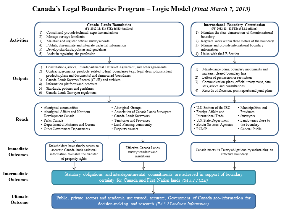
Text version
Annex A: Logic Model
Canada’s Legal Boundaries Program Logic Model (March 7, 2013). This diagram is a logic model flow diagram from the top down. Two streams are shown, the Canada lands boundaries component stream, and the international boundary commission stream. There are six levels shown: activities, outputs, reach, immediate outcomes, intermediate outcomes, and the ultimate outcome. Each stream has arrows connecting one level to the next. The streams merge at the intermediate outcome level. Activities level, Canada Lands Boundaries stream. Financial year 2012-13: 114 full time equivalents and 13.4 million dollars. Activity 1, consult and provide technical expertise and advice. Activity 2, manage surveys for clients. Activity 3, maintain and register official survey records. Activity 4, publish, disseminate and integrate cadastral information. Activity 5, develop standards, policies and guidelines. Activity 6, assist in regulating the profession. International boundary commission stream, financial year 2012-13: 11 full time equivalents and 2.1 million dollars. Activity 1, maintain the clear demarcation of the international boundary. Activity 2, regulate work within three metres of the boundary. Activity 2, manage and provide international boundary information. Activity 4, liaise with the United States Section. Output level, Canada lands boundaries stream. Output 1, consultations, advice, Interdepartmental Letters of Agreement, and other agreements. Output 2, contracts, geomatics products related to legal boundaries (for example legal descriptions, client products, plans and documents) and demarcated boundaries. Output 3, Canada Lands Surveys Record (C L S R) and archives. Output 4, information platforms and products. Output 5, standards, policies and guidelines. Output 6, Canada Lands Surveyor regulations. Output level, international boundary commission stream. Output 1, maintenance plans, boundary monuments and markers, cleared boundary line. Output 2, letters of permission or restriction. Output 3, communication plans, official treaty maps, data sets, advice and consultations. Output 4, records of decision, joint reports and joint plans. Reach level, Canada lands boundaries stream: Aboriginal communities, Aboriginal Affairs and Northern Development Canada, Parks Canada, Department of Fisheries and Oceans, other government departments, aboriginal groups, Association of Canada Lands Surveyors, Canada lands surveyors , territories and provinces, land planning community, property owners. Immediate outcomes level, Canada lands boundaries stream. Box 1, stakeholders have timely access to accurate Canada lands cadastral information to enable the transfer of property rights. Box 2, effective Canada Lands survey standards and regulations. Immediate outcome level, international boundary commission stream. Canada meets its treaty obligations by maintaining an effective boundary. Intermediate outcomes, one box for both streams. Statutory obligations and interdepartmental commitments are achieved in support of boundary certainty for Canada and First Nation lands (sub activity three point two point two Canada’s Legal Boundaries). Ultimate outcome. Public, private sectors and academia use trusted, accurate, Government of Canada geo-information for decision-making and research (program alignment architecture three point two Landmass Information).
Annex B: Evaluation Matrix
|
Evaluation Question |
Evaluation Sub-Question |
Indicator |
Lines of Evidence |
|
Relevance |
|||
|
Evaluation Issue 1: Continued Need for Program |
|||
|
R1. Is there a continuing need for the CLB program? |
R1 a) What needs are the CLB and IBC activities addressing? |
1. Identification of stakeholder needs addressed by CLB program. |
Document review |
|
R1 b) Are the needs continuing? |
1. Consistency (comparison) of stakeholder needs with CLB program activities, outputs and outcomes |
Document review |
|
|
R1 c) Has the CLB and/or IBC evolved to meet new or changing needs? |
1. Identification of new stakeholder needs that have arisen between 2009 and 2013 2. Identification of how new stakeholder needs are being addressed? |
Document review |
|
|
R1 d) Who are the CLB and IBC stakeholders, and has their number or nature changed in the last 5 years? |
1. Identification of stakeholders (clients, users, partners) 2. Identification of changes in stakeholders, if any, since 2009 |
Document review |
|
|
Evaluation Issue 2: Alignment with Government Priorities |
|||
|
R2. Is the CLB program consistent with government priorities and NRCan strategic objectives? |
R2 a) To what federal government priorities is the CLB and IBC linked? |
1. Consistency of CLB and IBC activities, outputs and outcomes with federal priorities. |
Document review |
|
R2 b) To what strategic departmental objectives and priorities are the CLB and IBC linked? |
1. Consistency of CLB and IBC activities outputs and outcomes with NRCan and ESS Strategic Outcomes and priorities. |
Document review |
|
|
Evaluation Issue 3: Alignment with Federal Roles and Responsibilities |
|||
|
R3. Is there a legitimate, appropriate and necessary role for the federal government in the CLB program? |
R3 a) Should the Government of Canada be involved in providing the -legal survey system for Canada Lands? |
1. Consistency of CLB component activities, outputs and outcomes with legislation; with federal role. |
Document review |
|
R3 b) Should the Government of Canada be involved in the IBC? |
1. Consistency of IBC component activities, outputs, outcomes with legislation; with federal role. |
Document review |
|
|
R3 c) Are there other parties who could deliver the CLB or IBC aspects that are now federally delivered? |
1. Identification of extent to which other parties have the capacity and/or mandate to deliver the CLB program components. |
Document review |
|
|
Performance - Effectiveness |
|||
|
Evaluation Issue 4: Achievement of Expected Outcomes |
|||
|
PS1. To what extent have intended outcomes been achieved as a result of the CLB program? |
PS1 a) To what extent do stakeholders have timely access to accurate Canada Lands cadastral information? |
1. Identification of stakeholder’s perceptions on timely access to Canada Lands cadastral information 2. CLB Service standards in respect to processing survey information are developed, monitored, changed and complied with. |
Document review |
|
PS1 b) To what extent do stakeholders have the correct Canada Lands cadastral survey information? |
1. Comparison of product/output compliance with standards. 2. Evidence of quality control measures. |
Document review |
|
|
PS1 c) To what extent does the survey information enable the transfer of property rights? |
1. Evidence of land transactions occurring on parcels defined by Canada Lands surveys. |
Document review |
|
|
PS1 d) To what extent are Canada Lands survey standards and regulations effective? |
1. Extent to which there are formal professional interactions on reviewing survey standards and regulations on an ongoing/regular basis? 2. Evidence of changes, improvements in standards and regulations in last five years? 3. Identification of any gaps, or areas to be developed in terms of standards and regulations. 4. Identification of support to the profession (capacity building, training, information outreach) |
Document review |
|
|
|
PS1 e) To what extent does Canada meet its Treaty obligations by maintaining an effective boundary (with the U.S.)? |
1. Comparison of treaty obligations to CLB program activities and outputs. 2. Evidence of Canada not meeting its treaty obligations. 3. Percentage (cumulative) of International Boundary Maintenance Canada-U.S. obligations on joint plan that are achieved (NRCan PMF) |
Document review |
|
PS1 f) To what extent are Statutory obligations and interdepartmental commitments achieved in support of boundary certainty for Canada and First Nation lands? |
1. Comparison of interdepartmental commitments with CLB program activities and outputs. 2. Comparison of statutory obligations and CLB program activities and outputs. 3. Percentage of statutory obligations and interdepartmental commitments achieved as defined in the legislation and agreements for Canada and First Nation (NRCan PMF) |
Document review |
|
|
PS1 g) To what extent do public, private sectors and academia use trusted, accurate Government of Canada geo-information for decision-making and research? |
1. Number of public, private sector, governments and academia that use CLB program information [NRCan information] for decision-making (NRCan PMF) 2. Percentage of clients who are satisfied with Canada's legal boundary framework for effective governance, economic and social development (NRCan PMF) 3. Identification of stakeholder’s usage of geomatic products for land transactions, research, or other decision-making (e.g. land use planning) |
Document review |
|
|
PS2. Have there been unintended (positive or negative) outcomes? |
PS2 a) Identify the unintended outcomes. |
1. Identification of the unintended outcomes, if any, of the CLB program. 2. Identification of factors external to the CLB program that may influence the achievement of activities, outputs and outcomes. |
Document review |
|
PS3. Are there clear linkages between outputs and outcomes |
PS3 a) To what extent do CLB program outputs contribute to outcomes. |
1. Stakeholders knowledge/awareness of CLB program activities and outputs. 2. Comparison of information dissemination activities/platforms/ strategies and stakeholder awareness of CLB program activities and outputs. 3. Identification of stakeholders' usage of geomatic products for land transactions, research, or other decision-making (e.g. land use planning) |
Document review
|
|
Performance – Efficiency |
|||
|
Evaluation Issue 5: Efficiency and Economy |
|||
|
PE1. Is the CLB program the most economic and efficient means of achieving outputs and progress toward outcomes? |
PE1 a) What is the difference between planned and actual spending? What explains this difference, if any? |
1. Comparison of planned and actual spending. |
Document review |
|
PE1 b) What steps has the CLB and/or IBC taken in order to minimize the use of resources in the achievement of results? |
1. Identification of efficiency and/or cost saving measures. |
Document review |
|
|
PE1 c) What, if anything, about the CLB and/or IBC needs to be adjusted? |
1. Identification of unmet needs, undesired outcomes, and design/delivery needs (as may be identified in R1, PS1) |
Document review |
|
|
PE1 d) To what extent have the CLB and IBC outputs been produced and at what cost? |
1. Comparison between CLB and IBC program anticipated outputs and actual outputs. 2. Approximate cost of production of outputs, as available. |
Document review |
|
|
PE2. Is performance information being collected and used on an ongoing basis? |
PE2 a) To what degree is CLB and IBC performance information used for decision-making by the CLB program? |
1. Identification of how CLB performance information is used for decision-making. |
Document review |
|
PE2 b). Have the recommendations of the previous evaluation been implemented? |
1. Identification of progress made in implementation of recommendations of previous evaluations. |
Document review |
|
Page details
- Date modified: