
Forest Change adaptation tools
Tools and resources to support forest adaptation to climate change
Forest Change program
Natural Resources Canada–Canadian Forest Service’s Forest Change program provides information about the impacts of climate change on Canada’s forests and on how to adapt to changing climate conditions. The initiative reports on indicators that reflect past trends in, and future projections of, changes across Canada. It also provides adaptation tools and resources for forest managers.
The adaptation tools and resources provided here are in a variety of formats, including maps, databases, web applications and synthesis reports. The tools and resources are grouped under the same broad systems as the indicators: climate, forest and human.
See also: Synthesis reports and reviews produced under the leadership of other organizations, such as the Canadian Council of Forest Ministers.
Climate system
Tools and resources grouped under the climate system provide useful data not only for the forest sector but also for other areas, such as agriculture and ecosystem restoration.
Climate modelling
- A web application that provides historical data and future projections of temperature, precipitation, growing season length and many other climatic variables for specific areas
- Helps users visualize the climate projections
Related resources and research
Related resources
- A guidebook on climate scenarios: Using climate information to guide adaptation research and decisions produced by Ouranos
- Environment Canada website for climate change information – Canadian Climate Data and Scenarios (CCDS)
- United States Department of Agriculture website for climate information – Climate Hubs
Related Canadian Forest Service research
Climate data for modelling
- Downscaled climate projections (maximum temperature, minimum temperature, precipitation, solar radiation, surface wind speed, and water vapour) using four different climate models
- Users can download the data they need for further research, analysis and modelling
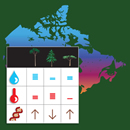
Forest system
Tools and resources grouped under the forest system provide information on composition and productivity, as well as disturbances and extreme events.
Vulnerability of Canada’s tree species to climate change
- Interactive maps showing vulnerability of Canada’s tree species to drought and migration failure
- Maps comprise two components: exposure to altered conditions relative to their current habitat, and the degree of sensitivity to drought or migration failure
Related resources and research
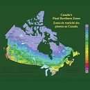
Canada’s Plant Hardiness
- A website that provides plant hardiness zone maps and species-specific climate niches
- A web application (the species-specific models and maps section) allows users to visualize the current and projected climate niches of more than 3,000 individual plant species
- Helps users consider climate change when selecting which species to plant
Related resources and research
Related resources
- United States Department of Agriculture, Agricultural Research Service – 2012 USDA Plant Hardiness Zone Map
- United States Department of Agriculture, Forest Service – Climate Change Tree Atlas
Related Canadian Forest Service research
SeedWhere
- A web application that functions as a climate similarity mapping tool
- Helps users match seed sources to planting sites under the current or a future climate
- Provides a systematic way to identify potential seed zones
Related resources and research
Related Canadian Forest Service research
Assisted migration of tree species
- A website that describes human-assisted movement of plants to more climatically suitable habitats, with links to articles, reports and resources
- A special issue of The Forestry Chronicle containing information on the ecological, practical and ethical issues surrounding assisted migration, and summarizing current knowledge of assisted migration
Related resources and research
Related resources
- Website on the Conservation of Forest Genetic Resources in Canada (CONFORGEN)
Related Canadian Forest Service research
Canada’s National Forest Inventory
- A website that describes Canada’s National Forest Inventory and provides links to maps, reports, documentation and other resources
- Data provide consistency across multiple jurisdictions and through time to assess forest change and measure progress toward sustainable forest management at the scale of Canada’s terrestrial ecozones
Bioclimatic Mapping of Forest Insects and Diseases
- A web application that provides broad-scale climate-based risk models (maps) of native and non-native forest insects and diseases in Canada
- Allows users to visualize the current and projected climate niches of more than 1,500 individual insects and diseases
- Summaries of the amount of host biomass and the intersection with the climatic ranges are also provided where possible
Spatial Discrete Event Simulation
- A platform that allows users to develop and run simulation models
- Users can create their own modules or use pre-existing modules
- Allows the integration of multiple modules across disciplines (e.g., plants, animals, insects, fires, ecophysiology, economics) to examine complex trade-offs and feedbacks across traditional management areas (e.g., pest management, fire management, economics, timber supply)
Mapping the Occurrence of Canada’s Forest Pathogens
- The forest pathogen database provides over 60 years of broad-scale location data for native fungi and other microbes, many of which cause disease in Canada’s forests
- Users can access currently known occurrence maps for almost 3000 individual forest fungi and mistletoes
- Data and/or maps can be downloaded and used in other applications – for example, integrated with other disturbances
Forest Change Data Catalogue
- A catalogue of data, maps and graphs that shows current status and projected changes in Canada for topics such as drought, fire, temperature and precipitation
- Users can print summary maps showing short-, medium- and long-term projections and download data for further analysis

National Tree Seed Centre
- A facility that collects, processes, tests and stores seeds of Canadian trees and shrubs for conservation and research purposes
- The seed centre has more than 14,000 seedlots (some over 60 years old) with seed from about 120 Canadian species and more than 45 non-native species
- Collection details are listed in the seed database
- Researchers may order small quantities of seed for research purposes at no cost
Related resources and research
Related Canadian Forest Service research
Human system
Tools and resources grouped under the human system provide support for the process of adaptation, through the exploration of vulnerabilities and adaptation options.
CCFM reports
- A series of reports from the Canadian Council of Forest Ministers that provide knowledge, tools and approaches for assessing forest sector vulnerabilities, risks and opportunities in a changing climate
- Provides a roadmap for the adaptation process
Related resources and research
Related resources
- A summary of the CCFM Climate Change Adaptation Report Series
Database of adaptation options
- An inventory of adaptation options proposed in the literature for the managed boreal forest
Related resources and research
Related resources
Related Canadian Forest Service research

PlantWatch
- A website that encourages Canadians to contribute to knowledge about how plants are responding to a changing climate
- Includes descriptions, diagrams and photos for plant identification, as well as tips for making observations
- Users can submit observations, view maps of results and download data
Forestry Adaptation Community of Practice (FACoP)
- An interactive online community for sharing information and best practices on climate change vulnerability and adaptation in Canada’s forest sector
- Join the community to access news and research articles, webinars, discussion forums, and a wiki space for co-creating documents
- Funded by the Canadian Council of Forest Ministers’ Climate Change Task Force
Synthesis reports and reviews
- Gauthier, S., Bernier, P., et al. 2014. Climate change vulnerability and adaptation in the managed Canadian boreal forest. Ottawa, ON: Natural Resources Canada. – Summarizes potential climate change adaptation actions and strategies for the forest management system, considering current and projected climate change impacts and their related vulnerabilities.
- Lemprière, T.C., Bernier, P.Y., et al. 2008. The importance of forest sector adaptation to climate change. Edmonton, AB: Natural Resources Canada–Canadian Forest Service. – Summarizes current knowledge about recent changes in the climate of Canada’s forests and projects further changes over this century.
- Price, D.T., Alfaro, R.I., et al. 2013. Anticipating the consequences of climate change for Canada’s boreal forest ecosystems. Environmental Reviews 21,322–365. – Summarizes the state of knowledge on climate change impacts in the Canadian boreal zone, focusing on likely impacts on forests within the next 50–100 years.
- Warren, F.J., and Lemmen, D.S. (eds.). 2014. Canada in a changing climate: Sector perspectives on impacts and adaptation. Ottawa, ON: Natural Resources Canada. – National Science Assessment highlights Canada’s changing climate and impacts on the natural environment, economy, and Canadians and describes the current state of adaptation.
- Williamson, T.B., Colombo, S.J., et al. 2009. Climate change and Canada's forests: From impacts to adaptation. Edmonton, AB: Natural Resources Canada–Canadian Forest Service and the University of Alberta. – Describes current and projected climate change impacts on Canada’s forests and the forest sector.
Page details
- Date modified: