
Floods and river ice break-up
The Government of Canada response to ice break-up and flood events is managed by the Government Operations Centre at Public Safety Canada and the Department of National Defense. Flood forecasts are available through regional and provincial flood forecasting centres across Canada.
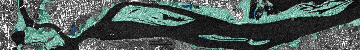
Natural Resources Canada’s Emergency Geomatics Services (EGS) provides critical, near real-time information to Public Safety Canada and emergency responders during ice break-up and flood events. EGS flood extent maps and river ice state maps are available to the public on Open Maps.
Floods and River Ice Monitoring in Canada
Note: For locations where EGS is currently activated by Public Safety Canada
Flood research and mapping
NRCan works with partners across the country to increase the knowledge base about river ice break-up and floods and to improve the ability of authorities to predict and manage flood risk:
- Many parts of Canada are missing up-to-date flood maps that delineate flood hazard zones, which are useful for flood risk planning and mitigation. The Minister of Natural Resources’ mandate letter includes working with the provinces and territories and Indigenous peoples to complete all flood maps in Canada.
- NRCan is developing the Federal Flood Mapping Guidelines Series to advance and standardize flood mapping activities across Canada. This will improve the accuracy of flood maps to support planning and emergency response.
- Emergency Geomatics Services at the Canada Centre for Remote Sensing (CCRS), a division of the Canada Centre for Mapping and Earth Observation (CCMEO), uses satellite-derived Earth observation imagery to actively monitor spring ice break-up and flooding and create real-time river ice state and open water flood extent maps to support emergency response activities in Canada and for international flood events (PDF, 1.2 MB).
- CCRS is using very high resolution imagery to develop Earth Observation-based methodologies for mapping urban floodplains for flood risk analysis, mitigation and disaster response. This research is supported by Public Safety Canada, and uses geospatial data from the 2013 Calgary flood made available to NRCan under a Data License Agreement with the City of Calgary.
- NRCan’s Adaptation to Climate Change Program facilitates the development and exchange of information, knowledge, and tools needed to plan and implement practical adaptation measures that increase the resilience of Canadian communities and industry to climate change, including more frequent flood events.
Data Collections
- Floods in Canada Map Collection
- River Ice State in Canada Collection
- Open Government Portal – Floods
- Open Government Portal – River Ice
Publications
- CCRS Emergency Response Activity Internationally (PDF, 1.3 MB)
- Federal Floodplain Mapping Guidelines Series
Find Out More
- Natural Hazards (NRCan)
- Remote Sensing Applications: Natural Hazards
- NRCan’s Role in the RADARSAT Constellation Mission
- Government Operations Centre (Public Safety Canada)
- Facts about Floods in Canada (Canada.ca)
- Flood Ready (Canada.ca)
- Flood Forecasting Centres Across Canada (Canada.ca)
Educational Resources:
Articles, Videos and Podcasts:
Page details
- Date modified: