
Towards Adaptation: Case Studies in British Columbia
Vulnerability and adaptive capacity to climate change in British Columbia's communities are a product of social processes and environmental conditions and especially their interaction at the local or regional scale (Dolan and Walker, 2007). Key factors influencing adaptive capacity in BC include the following:
- The heavy reliance on natural resources, particularly forestry, exposes BC communities to environmental and market changes, and to combined climatic and non-climatic stresses (O'Brien and Leichenko, 2000).
- Governance structures, which regulate how ecosystems can be used and accessed by people, mediate both the social and economic use of natural resources. Few existing structures explicitly consider climate change impacts; fewer still have implemented adaptation-specific policy changes.
- Diverse sociocultural values and competing socioeconomic interests underlie debates over how best to plan and protect resources and the environment. Climate change makes the process of reaching effective compromise more complex and the outcomes more difficult to predict.
The case studies presented in this section highlight how these factors and other aspects of a community, region or economic activity influence its capacity to adapt to climate change. In general, adaptive communities require resilient social networks, services, governance, infrastructure and economic activities that can withstand a variety of socioeconomic and environmental changes (e.g. Dolan and Walker, 2007; Young, 2006b; Ommer, 2007; Page et al., 2007; Enns et al., in press). Adaptive capacity can be enhanced, or constrained, by the nature and structure of decision-making relationships and planning policy. Increased stakeholder involvement in BC's sociopolitical landscape, at both local and regional scales (Hoberg, 1996; Seely et al., 2004), has enhanced incorporation of local values and interests into land-use planning. For instance, conflict over logging practices in old-growth forests in the 1990s (Stanbury, 2000; Cashore, 2001) led to the development of the multi-stakeholder Land and Resource Management Planning (LRMP) process (BC Ministry of Agriculture and Lands, 1993), which is typically enacted at the local to regional scale. The LRMP process has had some success in reconciling conflicting positions and contentious land and resource disputes (Frame et al., 2004), although it has not yet integrated potential climate change impacts and adaptation into its mandate (Hagerman and Dowlatabadi, 2006).
The effectiveness of governance, from local to higher levels, is another factor influencing adaptive capacity. At the local level, community planning is a key mechanism for stakeholders in BC to consider and incorporate the effects of climate change. Planning is guided by the BC Municipal Act and other policy instruments, including Official Community Plans (OCPs), local zoning and building codes, and the provincial Agricultural Land Reserve (ALR). Currently, few regional decision-making processes, policies and institutions explicitly consider the potential impacts of climate change. Regional planning districts, water districts and other ‘improvement districts' are mid-level jurisdictions in BC that will play a critical role in preparing for and managing some of the expected impacts of climate change (Jakob et al., 2003), such as for water supply and stormwater management (see Section 4.4; Burton et al., 2005).
At the provincial level, the BC Government released the report Weather, Climate and the Future: BC'ss Plan (BC Ministry of Environment, 2004), which discusses greenhouse gas mitigation and adaptation actions. The BC Ministry of Forests and Range (MFR) has also taken a proactive approach to integrating climate change considerations into medium- and long-term regional and resource planning procedures (BC Ministry of Forests and Range, 2006; see Section 4.2.2). The Ministry of Community Services, which provides funding for community infrastructure, is now increasingly considering climate change in reviewing proposals from local authorities (B. Kangasniemi, BC Ministry of Environment, pers. comm., 2007).
Finally, there are striking differences between urban and rural communities in BC in terms of local policies, growth patterns, planning issues and social attitudes. Climate change impacts and adaptation issues need to be seen as relevant to local concerns within communities' planning and risk management responsibilities. Issues such as water management in the Okanagan basin, sea-level rise in coastal communities and the impacts of the mountain pine beetle in BC's interior forest-based communities are examples that illustrate how impacts and steps toward adaptation are being experienced in BC. Although explicit integration of climate change considerations is relatively rare, these case studies provide perspectives on steps being taken towards adaptation to a variety of social, economic and environmental stressors.
4.1 COASTAL COMMUNITIES: VULNERABILITIES AND ADAPTATION TO SEA-LEVEL RISE
Climate change affects British Columbia's coastal communities through the gradual effects of accelerated sea-level rise and the more immediate impacts of extreme events, including increased storm-surge flooding, accelerated coastal erosion, contamination of coastal aquifers and various ecological changes. Such biophysical changes create risks of land loss, coastal infrastructure damage, coastal resource changes and shifts in related economic, social and cultural values (Klein and Nicholls, 1999). Climate change impacts are, and will continue to be, unevenly distributed among coastal communities due to differing local exposures and vulnerabilities (Clark et al., 1998; Dolan and Walker, 2007). These impacts are superimposed on non-climatic issues, including First Nations land claims, decline or collapse of key natural resource industries, economic restructuring, and the loss or reduction of social support and government services (Ommer, 2007; Sydneysmith et al, 2007).
A Canada-wide assessment of the impacts of sea-level rise (Shaw et al., 1998) defines ‘coastal sensitivity' as the degree to which sea-level rise will initiate or accelerate physical changes to the coast. Most of BC's coast is steep and rocky, and therefore has a moderate to low sensitivity. Exceptions include the northeastern coast of Graham Island, Haida Gwaii (Queen Charlotte Islands) and the Roberts Bank –Fraser Delta region in Greater Vancouver. These areas are ranked amongst Canada's most sensitive coastlines to climate change. However, this sensitivity analysis does not fully assess vulnerability to climate change, as it does not consider adaptive capacity (cf. Luitzen et al., 1992; Smit et al., 2001). Adaptive capacity is determined by socioeconomic setting (access to economic resources, political and social capital, and coastal planning policy) and local experiences with environmental hazards and socioeconomic changes (Dolan and Walker, 2007). The two cases presented here highlight communities experiencing similar physical impacts in very different socioeconomic settings. Key vulnerabilities, adaptive capacities and steps toward adaptation are discussed.
4.1.1 Northeastern Graham Island, Haida Gwaii (Queen Charlotte Islands)
Graham Island is the largest, northernmost island in the Queen Charlotte archipelago (Haida Gwaii). Relative sea level is currently rising at 1.6 mm/a and extreme annual sea levels at 3.4 mm/a (Abeysirigunawardena and Walker, in press). The shores of northeastern Graham Island consist mostly of highly erodible dune and bluff sediments. This, combined with high tides, energetic wave climate, frequent storm surges and high winds, creates a highly dynamic coastline with actively shifting beaches (Walker and Barrie, 2006). Water level and coastal erosion trends are strongly influenced by ENSO and PDO (Storlazzi et al., 2000; Dingler and Reiss, 2001; Allan and Komar, 2002; see Section 2.1). During El Niño 1997–1998, sea level rose 0.4 m and caused 12 m of local erosion along this shoreline (Barrie and Conway, 2002), and extreme water levels have increased significantly since the positive PDO shift of 1976 (Abeysirigunawardena and Walker, in press).
Climate change is one of many stressors affecting communities in Haida Gwaii. The local forest industry has experienced turbulent international timber markets, increasing costs of access, and changes in forest management, technology and protection, leading to declines in on-island processing and jobs. The local fishing industry has experienced changing populations of salmon, herring and clams, as well as restricted fishing privileges. In addition, closure of Canadian Forces Base Masset led to the out-migration of hundreds of people, resulting in further job losses and socioeconomic restructuring.
Adaptive Capacity
Dolan and Walker (2007) presented an integrated, human-environmental research framework to assess climate change –related risks and vulnerabilities of communities on northeastern Graham Island. Resulting research by Walker et al. (2007) involved assessment of climate change trends, impacts and sensitivities (Walker and Barrie, 2007; Walker et al., 2007; Abeysirigunawardena and Walker, in press), and a sociocultural assessment by Conner (2005) used a ‘participatory approach', incorporating local knowledge, perceptions and experiences to define attributes of adaptive capacity and identify key vulnerabilities. This study identified many attributes capable of strengthening adaptive capacity (Table 9) that may not be readily captured by the typical attributes of vulnerability, such as wealth. In Haida Gwaii, a historically high dependence on natural resources for jobs, below-average household incomes, high unemployment rates and income instability suggest a high vulnerability and low adaptive capacity. At the household level, however, socioeconomic resilience is enhanced by income diversification (multiple jobs, arts and crafts, tourism) and food gathering and stockpiling. This suggests a higher adaptive capacity to the risks of climate change than would be interpreted from income and employment statistics alone.
| Factors that increase vulnerabilityFootnote 1 | Factors that enhance adaptive capacityFootnote 2 |
|---|---|
|
|
|
|
|
|
|
|
|
|
|
|
|
|
|
|
Access to technology, information and skills, critical infrastructure and essential services are other community-level factors of adaptive capacity (Goklany, 1995; Barnett, 2001). Most critical infrastructure and transportation services in Haida Gwaii are highly vulnerable to coastal storm damage. Frequent power outages, interrupted ferry and flight service, short-term grocery and supply shortages, occasional highway closures and wind damage are commonplace. Most communication services are available in Haida Gwaii, including high-speed Internet and cellular phone coverage. Community messages are broadcast on local TV, in flyers and in the local newspaper. A tsunami evacuation plan exists, but is not well recognized, despite established protocols and tests. Recognition of the need to adapt, knowledge about available options, capacity to assess them and ability to implement the most appropriate options are all dependent on the availability of credible information and appropriate skills (Fankhauser and Tol, 1997).
Risk perception, awareness and preparedness are also attributes of adaptive capacity (Burton et al., 1978; Barnett, 2001; Smit et al, 2001; Dolan and Walker, 2007). Risk perception depends on knowledge and past experience with hazards, such that greater awareness comes with greater knowledge and experience (Hutton and Haque, 2004; Degg and Homan, 2005). Despite generally low levels of formal education in Haida Gwaii, high informal education, local and traditional environmental knowledge, and a diverse informal skill set (e.g. hunting, gathering and backcountry skills) result in a high general risk awareness and preparedness for natural hazards. However, many residents do not perceive risks from longer term climate change per se, compared to those associated with extreme events such as storms, coastal erosion or tsunami.
Social capital, which includes relationships, networks and infrastructure that support the flow of information and skills toward shared values, goals and collective action (Coleman, 1988; Tobin, 1999), is another important determinant of adaptive capacity. Communities with greater social capital may deal more effectively with hazards and the impacts of climate change (Buckland and Rahman, 1999). In Haida Gwaii, high social capital is suggested by strong community cohesion, numerous support networks, community activism and increasing local involvement in community services.
Institutions and governance also influence adaptive capacity. Historical conflict between community groups and orders of government on forestry and fishing, provision of services and local control in decision-making makes for a complex sociopolitical environment in Haida Gwaii. Longstanding negotiations between community groups, the Haida Nation and the BC government have yet to establish a Land Resource Management Plan (LRMP) for Haida Gwaii (Haida Gwaii –Queen Charlotte Islands Land Use Planning Process Team, 2006). An LRMP will be critical in determining future planning in Haida Gwaii; however, climate change considerations, such as coastal setbacks and limiting development on eroding coasts, are not part of the current report's recommendations.
Impacts and Adaptation
Projected future impacts associated with changing climate include increasing coastal erosion, rising storm-surge damage and flooding, more frequent disruptions to critical transportation services, likely loss of coastal sections of Highway 16, rising costs of infrastructure maintenance, changes to coastal habitat and species abundance (crabs, clams) that will affect both commercial and sport fishing, and changes in the form and ecology of Rose Spit, an ecological reserve and Haida spiritual site.
Walker et al. (2007) have provided several adaptation considerations that build on existing community strengths and locally defined vulnerabilities. Adaptive planning is needed to reduce the vulnerability of exposed critical infrastructure, including coastal roads, low-lying buildings and airports, power-communication transmission lines and essential services. Possible initial actions include continued protection of vulnerable coastal stretches of Highway 16 and upgrades to existing logging roads for an alternate inland route. Consideration of coastal setbacks and land-use rezoning along eroding and flood-prone coastal areas are still needed. Economic development and renewal initiatives in tourism, arts, culture and resource stewardship will continue to diversify the local economy, enhancing community resilience. Enhancement of existing cultural, socioeconomic and political strengths will also improve overall adaptive capacity of Haida Gwaii communities to longer term climate change.
4.1.2 Roberts Bank, Greater Vancouver Regional District
The Roberts Bank tidal flats are located on the seaward edge of the Fraser River delta, bordering the Corporation of Delta and the Tsawwassen First Nation (TFN). The Corporation of Delta is a mixed urban and rural community that forms part of the Greater Vancouver Regional District. Delta and TFN are protected from river and storm-surge flooding by dykes along the river and shoreline. The tidal flats provide an important habitat for both birds and fish. Thousands of waterfowl, shorebirds and gulls use the tidal flats (Vermeer et al., 1994). Extensive beds of native eelgrass (Zostera marina) provide important spawning habitat for Pacific herring and feeding grounds for juvenile chinook and coho salmon (Levings and Goda, 1991).
The issue of assessing rising sea level and changing storm impacts on the Roberts Bank tidal flats involves complex stakeholder values and interactions (Hill et al., 2004). Two major causeways cross the southern end of Roberts Bank: a Vancouver Port Authority (VPA) structure providing access to the Delta Port shipping terminal and a BC Ferries Corporation structure serving a major ferry terminal. Both causeways were constructed in the 1950s, with little consultation with the communities, causing longstanding grievances and tensions. Stakeholder interviews identified key issues and positions around land and resource management on Roberts Bank. This information was used to design a workshop deliberation of potential climate change concerns, unhindered by historical grievances. Key concerns identified at the workshop included the integrity of infrastructure (dykes, causeways and port facilities), increased flood risk, loss of fresh water for irrigation during the summer, and loss of fish and bird habitat.
Impacts and Adaptation
The main biophysical impacts of sea-level rise on the tidal flat environment are summarized in Table 10 (Hill, in press). The projected range of net relative sea-level rise for Roberts Bank is 0.23 to 1.02 m by 2100, based on Intergovernmental Panel on Climate Change (2001) projections of global sea-level rise, the historical rate of relative sea-level rise from tide-gauge data, and new ground subsidence data. Land subsidence in the Delta region accounts for 0.2 to 0.3 m of this relative rise (Mazzotti et al., 2006).
| Element | Effect | Impact | Confidence level |
|---|---|---|---|
| Global sea-level rise | 0.08–0.88 m by 2100 (Intergovernmental Panel on Climate Change, 2001) | High | |
| Land subsidence | 2–3 mm/year in the Fraser River delta | High | |
| Net relative sea level rise | Median values using 2 mm/yr subsidence: 2030: 0.17 m 2050: 0.27 m 2100: 0.62 m |
High | |
| River flood frequency | Flood return periods will decrease due to rising base (sea) level, leading to higher risk | Negative | High |
| Marsh | Erosion of marsh due to coastal squeeze and increased wave attack; mitigated by natural marsh accretion up to a threshold rate | Negative |
|
| Mud flat | Projected 45–63% reduction in area due to coastal squeeze; mitigated by some sedimentation over present marsh area; may be exacerbated by increased storminess and wave action | Negative | Low |
| Eelgrass | High modern expansion rates suggest eelgrass will migrate landward with changes in water depth | None | Moderate to high |
| Biofilm | Area likely to decrease with reduction in mud flat; higher wave energy may coarsen sediment and reduce productivity | Negative | Low |
| Predation of shorebirds | Likely to increase due to landward migration of optimum feeding grounds into range of predatory raptors (Butler, 1999). | Negative | Low |
The tidal flats are characterized by different ecological zones supporting distinct habitats. These zones tend to migrate inland in response to rising sea levels. However, the presence of dykes impedes natural shoreline migration with sea-level rise, effectively 'squeezing' these zones against the dykes (Clague and Bornhold, 1980; Hughes, 2004). As sea level rises, wave motions presently attenuated by friction over the shallow delta surface will increase in amplitude, resulting in increased sediment transport and potential erosion of the marsh. This will be exacerbated greatly if the frequency of intense storms increases. Although uncertainties exist regarding marsh accretion and future sediment transport rates, it is expected that the mud-flat area will decrease significantly over the next century. These changes are likely to have a negative impact on certain bird populations (Hill, in press), as the marshes and mud flats are critical feeding habitat for migratory birds, such as the western sandpiper (Elner et al., 2005). Sea-level rise, as well as development pressures, will likely favour continued expansion of eelgrass beds, thus favouring fish habitat and bird species that feed on them, such as heron.
An immediate outcome of the Roberts Bank study (Hill, in press) is, as stated by the mayor of the Corporation of Delta, to make climate change and its effects on Delta a priority in the coming three years. A survey of municipal officials, including scientists, engineers and planners, demonstrates a high level of concern about the effects of climate change. Key concerns include the implications of sea-level rise and storm surges for protection of critical infrastructure and the natural environment. The effects of rising sea level are now being considered in a re-evaluation of dyke design by Delta, and in the development of an adaptive management plan for the Delta Port expansion project. A preliminary set of climate change impact indicators (Gregory et al., 2006), including biophysical (e.g. shoreline erosion, sedimentation), ecological (e.g. critical habitat area), socioeconomic (e.g. agricultural revenue), infrastructure (e.g. dyke integrity) and cultural (e.g. area of traditional land use), will provide a basis for future adaptive planning.
4.1.3 Summary and Lessons Learned
The Haida Gwaii study highlights aspects of remote coastal communities facing climate change and sea-level rise. Findings include the following:
- Remote communities and residents possess many resilient socioeconomic and sociocultural attributes that enhance their adaptive capacity to climate change risks in an otherwise exposed environment.
- Community responses to past social, cultural and/or economic changes provide key information on elements of adaptive capacity to climate change (e.g. social capital, community cohesion).
- Despite inherent resiliencies, adaptive capacity to long-term impacts is challenged by 1) direct exposure to coastal storms and sea-level rise; 2) dependence on vulnerable critical infrastructure and limited essential services; 3) limited economic resources to cope with continued and increasing impacts; and 4) limited land-use development plans that typically do not consider climate change.
In the urbanized, complex multi-stakeholder situation represented in the Roberts Bank study, key findings include the following:
- Careful design of the stakeholder process is required to alleviate pre-existing conflicts and enable focused discussion on climate change issues.
- An analytical-deliberative process is required, whereby technical analysis informs deliberations that, in turn, refine understanding of overall risks (Committee on Protection and Management of Pacific Northwest Anadromous Salmonids, 1996), thus providing a mechanism for moving towards adaptation. This process needs to be iterative to allow technical experts and stakeholders to converge on a common understanding of key vulnerabilities and adaptation options.
- In coastal environments with considerable human interventions, climate change is superimposed on a variety of other biophysical changes. As such, climate change impacts must be assessed as part of a broader suite of cumulative environmental impacts occurring at a site.
Common findings from these studies relevant to other Canadian coastal communities include the following:
- Climate change is only one of many risks, changes and challenges facing coastal communities. This stresses the need to understand past community responses (e.g. social and economic restructuring, coastal development and infrastructure measures), in order to plan for future changes. Interventions in the coastal zone benefit from cumulative impacts assessments and integrated coastal zone management (ICZM) planning. Jurisdictional issues and historical conflicts can present key barriers to ICZM implementation.
- Community involvement is key to obtaining locally relevant results for adaptive planning. Reasonable time frames of 5 to 10 years are required to properly engage community stakeholders and develop feasible adaptation measures.
- The timelines required for community planning that incorporates consideration of climate change are long compared to most community planning processes in British Columbia. Rates of sea-level rise are initially slow but are likely to accelerate with time. Climate change risks (e.g. erosion, groundwater contamination, storm flooding, increasing transportation and infrastructure costs) are insidious and may occur sporadically. Thus, communities are faced with more complex risk analysis and high levels of uncertainty in the planning of infrastructure and land use. Furthermore, the process of adaptation evolves through time from early actions and monitoring of key indicators toward longer term planning strategies.
4.2 CENTRAL AND NORTHERN BRITISH COLUMBIA: MOUNTAIN PINE BEETLE AND FOREST-BASED COMMUNITIES
The communities and landscape of central and northern British Columbia epitomize the historical role of forestry in the province's development. Today, forestry management practices of the past have collided with contemporary climate conditions to produce a dramatic example of the impact of changing climate in Canada. This case study looks at the causes and consequences of the current outbreak of mountain pine beetle, how one forest-dependent community is attempting to understand its own vulnerability, and at a recent initiative of the provincial Ministry of Forests and Range that is taking a proactive approach to incorporating climate change impacts and adaptation into long-range forest resource planning and management.
4.2.1 Mountain Pine Beetle
The mountain pine beetle (MPB) is a native insect that occurs from northern Mexico to central British Columbia. It feeds on the succulent tissues beneath the bark of most pine species in its range (Furniss and Schenk, 1969). Although MPB is normally innocuous, populations periodically erupt into outbreaks that kill millions of trees over large areas (Taylor et al., 2006).
Mountain pine beetle outbreaks have occurred in BC several times during the twentieth century, but the area affected by the present outbreak is nearly 10 times greater than any previously recorded. In 2007, MPB infestations were recorded over 9.2 million ha of pine forests (BC Ministry of Forests and Range, 2007). For a MPB outbreak to occur, two main conditions must be satisfied. First, there must be an abundance of large, mature pine trees. As a result of fire suppression and historical factors, there was over three times the amount of mature pine in BC at the start of the current outbreak compared with 100 years ago (Taylor and Carroll, 2004). Second, there must be several years of favourable weather for beetle survival: specifically, warm summers for beetle reproduction and mild winters that allow their offspring to survive (Safranyik and Carroll, 2006). The climate in central BC during recent decades has been highly suitable for beetle survival, most notably in the lack of sustained cold conditions in winter (Carroll et al., 2004). The result has been the largest outbreak of mountain pine beetle in history.

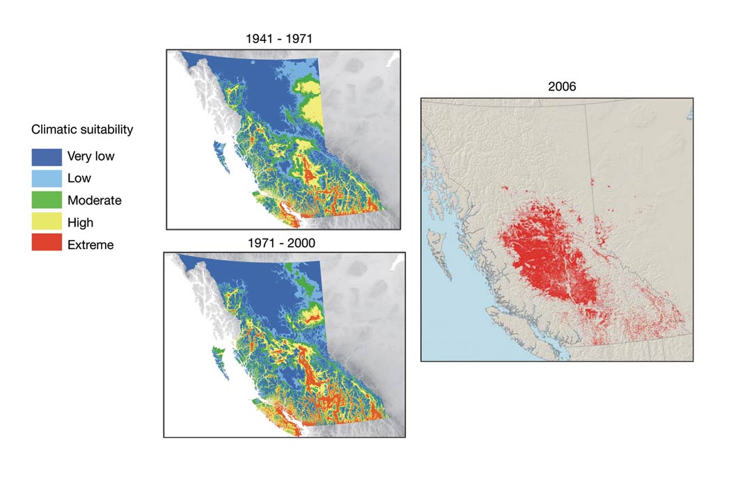
FIGURE 10: Left: Historical distributions of climatically suitable habitats for the mountain pine beetle (MPB) in British Columbia (adapted from Carroll et al., 2004). Areas with 'very low' suitability are unsuitable for MPB, where as 'extreme' areas are those considered climatically optimal. Right: Total area affected by mountain pine beetle in British Columbia in 2006 (Natural Resources Canada, 2007)
In addition to the unprecedented size of this outbreak, the range of MPB is expanding into formerly unsuitable habitats, especially toward the north and east (Carroll et al., 2004). The present range is not restricted by the availability of suitable host trees, as pine forests extend north into the Yukon and the Northwest Territories, and east across the continent as part of the boreal forest. Instead, the potential for beetles to expand north and east has been limited by climate (Safranyik et al., 1975). Modelling indicates that climate conditions favourable to MPB have recently improved over large portions of western Canada (Figure 10), increasing the amount of climatically optimal habitat by more than 75% (Carroll et al., 2004). Climate change scenarios discussed by Flato et al. (2000) suggest continued expansion of favourable conditions for MPB eastward into Alberta and north into the boreal forest.
The unprecedented tree mortality associated with the current MPB epidemic significantly impacts forest hydrology (Figure 11; H élie et al., 2005). The current and projected MPB infestation in BC will kill enough trees to cause greater exposure of soils to precipitation, potentially deeper snow accumulation and earlier melt, thereby increasing the risk of flooding. Such modifications to the hydrological cycle may account for observed changes in annual water yields and peak flows, and increased base flows/low flows in watersheds affected by MPB (Forest Practices Board of BC, 2007; cf. Cheng, 1989). More recently, other regions in BC have reported the occurrence of higher water tables (e.g. Vanderhoof Forest District) in MPB-affected areas (BC Ministry of Forests, 2005). The City of Prince George is also concerned about the potential for a heightened risk of flooding in low-lying parts of the city due to anticipated rises in the levels of the Nechako and Fraser rivers, especially during spring runoff (Dyer, 2006).
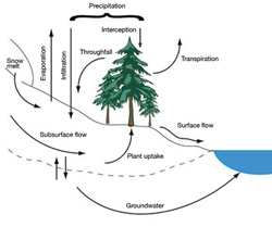
FIGURE 11: Forest hydrological cycle (adapted from Hélie et al., 2005)
The magnitude of hydrological impacts resulting from an MPB infestation depends on the extent and location within the watershed, as well as the geography of the watershed. Although these impacts will decrease as affected areas recover, higher flows could persist, at a decreasing rate, for as long as 60 to 70 years (Troendle and Nankervis, 2000). Some evidence suggests that harvesting MPB infested trees could advance the timing of hydrological recovery, as compared to a worst case scenario for natural regeneration (Dobson Engineering Ltd., 2004). Better understanding of the impacts of MPB and related harvesting on the hydrology of forested watersheds in BC is needed to determine appropriate levels of intervention and guide broader adaptation measures.
4.2.2 Vulnerability of Forest-Based Communities
The implications of changes in forest resources for residents of Vanderhoof and its surrounding region in north-central British Columbia exemplifies the challenges facing close to 110 forest-dependent communities in British Columbia. Although these communities face the same general impacts associated with climate change as other communities in BC, there are additional factors affecting their vulnerability. First, their economic dependence on extraction and processing of forest resources means that the local economy is highly sensitive to climate-induced changes in resource availability (Davidson et al., 2003). This economic exposure is magnified by the fact that climate change may lead to relative increases in the supply of timber and forest products from other nations, resulting in increased competitive pressures on the BC forest industry (Perez-Garcia et al., 2002; Sohngen and Sedjo, 2005). Second, many forest-based communities are relatively small and remote, with undiversified economies and specialized labour forces, limiting their capacity to adapt to climate change. Third, as the incidence and severity of wildfires are projected to increase as a result of climate change (Flannigan et al., 2005), forest-based communities will face increased risk of property loss, evacuation and deterioration in air quality due to increased fire activity (Davidson et al., 2003). Fourth, forest management and large-scale forest-processing facilities represent long-term investments that are difficult to reverse. Forestry decision-makers face long investment periods, dynamic risk and uncertainty that increase relative to the length of the forecast periods (Davidson et al., 2003). These factors underscore the importance of risk management in forestry and forest-based communities as an adaptation to climate change (Ohlson et al., 2005).
Vanderhoof has a population of 4400 with strong economic and social ties to the surrounding forest land base. The forest sector accounts for about 63% of the economic base of the community. The most immediate effect of changing climate on Vanderhoof is the current mountain pine beetle epidemic. The outbreak is having, and will continue to have, significant impacts on resource supply and local production of forest products. Prior to the MPB outbreak, the historical allowable harvest rate in the Vanderhoof Forest District was around 2 million m3 per year, whereas the current annual harvest target is 6.5 million m3 (Pederson, 2004). This increase has been implemented to utilize beetle-killed timber. Once the MPB has subsided (i.e. within about 10 years), the annual harvest level is projected to drop to between 1.25 and 1.75 million m3 (Pederson, 2004). Thus, the Vanderhoof economy will experience significant volatility over a short time period. The challenge for Vanderhoof will be to manage this transition by ensuring that reductions in natural capital caused by the mountain pine beetle are offset by increases in other forms of useable capital (human-made capital, new forest or alternative land uses), to ensure that the long-term economic viability of the region can be maintained (cf. Pezzy 1989; Solow 1991).
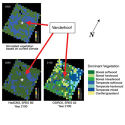
FIGURE 12: Simulated vegetation cover in the Vanderhoof study area, British Columbia (using IBIS, a dynamic global vegetation model), based on current climate and, at the turn of the next century, under two alternative climate scenarios (Source: D. Price, Natural Resources Canada). Study area is approximately 200 km by 200 km, with Vanderhoof at its centre. Each grid simulated by the IBIS model measures 10 km by 10 km
Residents of Vanderhoof also have a strong cultural and psychological connection to their surrounding forest landscape, and are very concerned about the long-term implications of environmental changes for the community and future generations (Frenkel, 2005). The Canadian Forest Service is developing methods to simulate the long-term effects of climate change on forests at scales most relevant to communities. These methods have been applied to a 40 000 km2 study area around Vanderhoof, to simulate future distributions of forest cover type in the year 2100 under two different climate futures (Table 11, Figure 12). Both simulations indicate significant changes in forest composition and provide general indications of potential changes over the next 100 years. The long-term impacts of climate change in terms of the nature and magnitude of forest ecosystem effects are not necessarily catastrophic — although the composition of the forest will change, forest cover will continue to exist under all future climate scenarios considered.
| Vegetation/forest type | Present-day (ca. 2000) | HadCM3-B2 (ca. 2100) | HadCM3-B2 CSIRO2 - A2 (ca. 2100) |
|---|---|---|---|
| Temperate softwood | 46 | 24 | 6 |
| Temperate hardwood | <1 | 0 | 10 |
| Boreal softwood | 54 | 75 | 26 |
| Boreal hardwood | 0 | 0 | 14 |
| Temperate mixed | <1 | 1 | 33 |
| Boreal mixed | 0 | 0 | 11 |
| Conifer-grassland mixed | 0 | <1 | 0 |
The Vanderhoof case study highlights that information on the magnitude and timing of impacts at locally relevant scales is required to facilitate consideration of adaptation. The experience of Vanderhoof also shows that the goal of managing a single resource in a sustainable manner may be difficult to achieve at a community level. Instead, reduction in one form of capital, in this case forests, may need to be offset by increases in other forms of capital, such as more land in agriculture or investment in new industries.
4.2.3 British Columbia's Climate Change Task Team and Future Forest Ecosystems Initiative
Climate change will play a major role in shaping the composition and use of forests in British Columbia. In recognition of this fact, the British Columbia Ministry of Forests and Range (MFR) established two interconnected initiatives to examine the potential future condition of forest ecosystems and to identify management responses. These initiatives recognize climate change as one important influence—along with global competition and new working relationships between governments and First Nations—on the future of forests, the forest sector and forest-based communities in BC. They reflect an effort to move from studying impacts to implementing adaptation.
In the fall of 2005, the MFR established a Climate Change Task Team to review potential impacts of climate change on provincial forest and range resources, identify knowledge gaps and develop recommendations on how the MFR could respond. Recommendations from the team were released in a report entitled Preparing for Climate Change: Adapting to Impacts on British Columbia’s Forest and Range Resources (BC Ministry of Forests and Range, 2006). The Future Forest Ecosystems Initiative (FFEI), launched in December 2005, brought together representatives from academia, provincial and federal government agencies, First Nations, the forest industry, consultants and environmental organizations for a two-day symposium and workshop.
The MFR consulted widely on the reports of the Task Team and the FFEI. The recommendations from the reports and the consultations were amalgamated under the goal of adapting BC's forest management framework to changing climatic conditions. This will be achieved by increasing the understanding of ecological processes and the risks to forest ecosystems, and by communicating how to adapt the forest management framework to the changing environment. Strategies are being developed to meet these objectives. Although it will be a few years before operational adaptation actions are implemented, consultation, capacity building and vulnerability assessments are the first steps in the adaptation process.
4.3 SOUTHERN INTERIOR: OKANAGAN AND COLUMBIA BASIN REGIONS
The southern interior of British Columba includes the Okanagan region and the upper Columbia River basin. Both watersheds feed into the lower Columbia River system. The major climate adaptation challenge in both areas is the need to manage water resources for multiple, often competing uses. The Okanagan is experiencing rapid growth in population and irrigated agriculture, while the Columbia region is unique because of its importance to BC's hydroelectric power grid and the Columbia River Treaty with the United States. Both areas are also faced with issues concerning the management and conservation of fisheries resources. The discussion below reflects the fact that there is substantially more research available on the Okanagan.
4.3.1 Water Issues
The Okanagan is already experiencing stresses on its water systems associated with rapid population growth and land-use changes (Cohen et al., 2004, 2006). Recent droughts in 2001 and 2003 are examples of short-term extreme events that have affected water supply, water demand and perceptions of risk in the region. The drought of 2003 saw the emergence of local water conflicts (Moorhouse, 2003) and the implementation of both emergency and longer term conservation measures (Johnson, 2004). These droughts have raised awareness about climate sensitivities, and possibly about vulnerability to climate change. When coupled with anticipated population growth, concerns about fisheries and aquatic ecosystems, and long-term directions in regional development, the implications of future climatic change become an important addition to the concerns that need to be addressed by water planners and managers in this region.

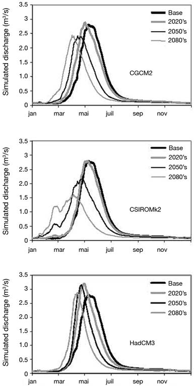
FIGURE 13: Hydrological scenarios for Whiteman Creek, British Columbia, using 3 models (CGCM2, CSIROMk2 and HadCM3) and the A2 emissions scenario (Merritt et al., 2006)
The diversity of views in the region regarding the implications of climate change provided the foundation for a dialogue on how the region might adapt to climate change (Cohen et al., 2000). Research described potential impacts on hydrology and water management of the Columbia River system, including potential trade-offs between managing for hydroelectric production versus in-stream flows for fisheries (Payne et al., 2004). Within the Okanagan, case studies addressing hydrology and crop-water demand (Cohen and Kulkarni, 2001; Neilsen et al., 2001) were followed by collaborative work that included estimates of the region's water balance, considering both agricultural and residential water demand (Neilsen et al., 2004a,b). This also included adaptation experiences, a preliminary look at costs of adaptation options and a dialogue on potential implementation of adaptation options.
Climate change scenarios based on two emissions scenarios (A2 and B2) and three climate models were used to generate hydrological scenarios for various catchments in the Okanagan watershed for three time periods (2020s, 2050s and 2080s; Merritt et al., 2006). All results suggest an earlier snowmelt peak in spring, with reduced summer flows and increased winter flows, although the shape of this peak varies considerably (Figures 13 and 14). The hydrographs built from these scenarios proved to be an important tool for translating the implications of climate change into terms that are meaningful and tangible to local decision-makers.

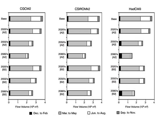
FIGURE 14: Projected hydrological responses in flow volume using three climate models and two emissions scenarios (A2 and B2) for Vaseux Creek, Okanagan watershed, British Columbia (Merritt et al., 2006)
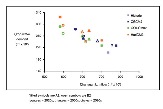
Hydrological scenarios for the Okanagan watershed are similar to those for the Columbia River system as a whole. Maximum snowpack would occur up to 4 weeks earlier by the 2080s. Spring peak flow would be 15 to 40 days earlier by the 2050s, and 20 to 70 days earlier by the 2080s. Earlier and smaller snowpacks have a critical impact on the Columbia River system due to the snowpack's importance to the continuity of hydroelectric power generation (Columbia Mountain Institute for Applied Ecology, 2003). Annual supply from surface-water sources would vary from modest decreases to extreme reductions of around 65% by the 2080s (Merritt et al., 2006). At the same time, agricultural and residential water demand are projected to increase, thereby increasing the likelihood of water shortages. Crop-water demand in the 2080s would increase by up to 60% due to the longer and warmer growing season, although factors such as land-use change and carbon dioxide fertilization will affect this estimate (Neilsen et al., 2004a, 2006). A comparison between inflows to Lake Okanagan and projected crop-water demand shows that the overall ratio of demand to supply would increase from approximately 25 to 50% (Figure 15).

FIGURE 15: Projected changes in Okanagan Lake inflows and crop-water demand (Neilsen et al., 2004a)
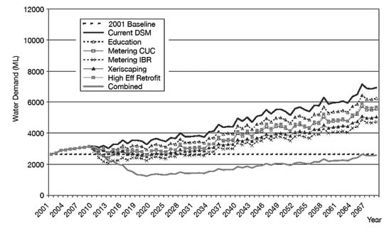
Anticipated population growth and a longer growing season could result in substantial increases in residential demand. A case study of Oliver, BC shows that demand could triple by the 2080s. Implementation of a portfolio of demand-side measures could slow down the projected increase in demand (Figure 16), buying time for the community to consider any requirements for increased water supply (Neale et al, 2006). Without specific measures to manage agricultural, residential and aquatic ecosystem maintenance demands, as part of a broader adaptation portfolio, total annual demand will exceed available annual inflows in the Okanagan watershed later this century (Langsdale et al., 2006).

FIGURE 16: Projected changes in residential water demand, Oliver, British Columbia, due to population growth and climate change, and assumed application of demand-side adaptation measures (Neale et al, 2006)
Adaptation
The Okanagan basin has had considerable experience adapting water systems to new challenges and opportunities. Examples include the regionalization of water delivery systems in Vernon, and the installation of meters in the Southeast Kelowna Irrigation District (SEKID) and the City of Kelowna. In SEKID's case, the trigger for action was dry conditions in 1987. Decisions were made through various means, sometimes aided by provincial incentives or influenced by environmental pressures or changing costs. So far, the SEKID and Kelowna cases appear to show that the measures were effective in reducing water demand, although it is too early to assess the outcome of regionalizing Vernon's water delivery (Shepherd et al., 2006). In terms of adapting to future climate change, there is a wide range of measures available at varying costs (Hrasko and McNeill, 2006), recognizing that other factors in addition to cost will influence decision-making (Tansey and Langsdale, 2004). For example, dialogue participants in Oliver expressed interest in expanding usage of groundwater, and agreed with the need to be more efficient water users. However, they were concerned that improvements in efficiency of water use by agriculture might lead to a loss of water rights in favour of residential uses, and lead to rapid population growth. In Westbank, part of a planning unit known as the Trepanier Landscape Unit (TLU), an area experiencing rapid population growth, dialogue participants expressed interest in increasing water supply through pumping from Okanagan Lake and in improving efficiency through leak detection and other means.
A basin-wide workshop, held in Kelowna, was a more strategic discussion. Support was expressed for basin-wide integration of land and water planning, and a governance structure to reflect this. Concern was expressed regarding a perceived lack of public awareness of regional water resource problems, and the need for expanded public education. An important outcome of this participatory approach to climate impacts and adaptation research has been the explicit inclusion of climate change in the Trepanier Landscape Unit Water Management Plan (Summit Environmental, 2004).
4.3.2 Agriculture
Crop production in the Okanagan basin is entirely dependent on irrigation, and agriculture accounts for 75% of consumptive water use. Currently, the region supports mostly perennial crops (high-value tree fruits and wine grapes, with the balance in pasture and forage) and a small acreage of annual crops (silage corn, vegetables) planted in suitable microclimates. Economic production of high-value crops requires timely availability of water, both to assure quality and to protect investment in perennial plant material. Planned water deficits are used to enhance quality attributes in some crops, including wine grapes (Dry et al., 2001), while conserving water. Consequently, potential limitations and adaptation to the availability of irrigation water under current and future climates are important considerations for agriculture in BC.
Although changes in average climate will determine, in the long run, which crop production systems are viable in a region, extreme climate events present a greater challenge to adaptation (Intergovernmental Panel on Climate Change, 2001). The major risk facing Okanagan agriculture is the occurrence and frequency of drought, and the resultant lack of water that puts irrigation-dependent agriculture at risk.
Water demand models using climate scenarios from three GCMs and two emissions scenarios all project increased demand for water in the Okanagan basin, ranging from 12 to 20% in the 2020s, 24 to 38% in the 2050s to 40 to 61% in the 2080s (Neilsen et al., 2006), reflecting increases in peak demand and in growing season length (30 to 35% longer by 2100 for all crops). Increased evapotranspiration is the most important factor in the increase in crop-water demand. In a case study of one sub-basin (Trout Creek) with predominantly agricultural water demand, the frequency with which modelled crop-water demand exceeded a dam storage threshold increased over the century in response to all climate change scenarios (Neilsen et al., 2006). Coupled with increased drought frequency associated with climate change, it is apparent that the existing water infrastructure, typical of many upland storage reservoirs in the region, will be unable to meet demand in years of extreme climate.
Producer Vulnerability
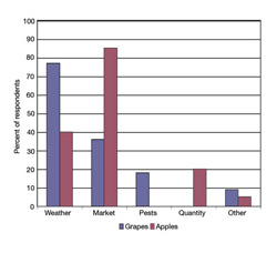
FIGURE 17: Risks that characterize bad economic years, as identified by grape and apple producers, Okanagan valley, British Columbia (Belliveau et al., 2006a, b)
Two separate studies of the vulnerability of apple and grape producers to climate and other risks have been carried out in the Okanagan valley (Belliveau et al., 2006a, b), using methodology from Ford and Smit (2004). Producers were asked a structured series of questions to characterize good and bad years and the management strategies they used in response. All factors affecting production and returns were considered, with climate change and variability introduced only at the end of the survey. The risks identified by apple and grape producers differed, despite co-location of the two industries. For grape growers, weather-related risks were critical (Figure 17) and confirmed by examination of long-term weather and crop production records (Table 12; Caprio and Quamme, 2002). Although apple growers also cited weather as a major concern in defining good and bad production years, market price was considered the most important determinant (Figure 17). A combination of low market prices and bad weather resulting in lower quality fruit was identified as the worst-case scenario. As with the grape growers, winter kill and cold damage, as well as high summer temperatures and damage from hail storms, are the main climate-related concerns.
Planning Summary Table
| Résultat stratégique | Programme | Dépenses réelles 2010–11 | Dépenses réelles 2011–12 | Dépenses projetées 2012–13 | Dépenses prévues | Cohérence avec les résultats du gouvernement du Canada | ||
|---|---|---|---|---|---|---|---|---|
| 2013–14 | 2014–15 | 2015–16 | ||||||
| S'assurer que la planification et la construction du tronçon canadien du projet de gazoduc de la route de l'Alaska s'effectuent de façon efficiente et rapide tout en garantissant la protection de l'environnement et des retombées socioéconomiques pour les Canadiens, | Surveiller et réglementer la planification et la construction de la portion canadienne du projet de gazoduc de la route de l’Alaska | 1 124,6 | 2 107,6 | 2 067,9 | 3 123,9 | 1 923,9 | 1 923,9 | Forte croissance économique |
| Total partiel | 1 124,6 | 2 107,6 | 2 067,9 | 3 123,9 | 1 923,9 | 1 923,9 | ||
| Phenological stage | Plant factor | Climate effect | Apple | Cherry | Apricot/ peach |
Grape |
|---|---|---|---|---|---|---|
| Current year | ||||||
| Dormancy | Winter hardiness | Detrimental | < –7°C to < –29°C from Nov. to Feb. | < –13°C to < –24°C from Nov. to Feb. | < –13°C to < –24°C from Nov. to Feb. | < –6°C to < –23°C from Nov. to Feb. |
| De-acclimation | Detrimental | 5°C in Jan.-->> 5°C in Jan. | 9°C from Nov. to Dec.-->> 9°C from Nov. to Dec. | |||
| Root protection | Beneficial | Snowfall | Snowfall | Snowfall in Jan. | ||
| Bloom | Spring frost injury | Detrimental | < 5°C | < –2°C | < –2°C | |
| Pollination / pollen tube growth | Outside optimum temperature range | Detrimental | 28°C day; < 10°C night-->> 28°C day; < 10°C night | |||
| Beneficial | 21°C day; > 11°C night-->> 21°C day; > 11°C night | 16°C-->> 16°C | 16°C-->> 16°C | |||
| Fruit-cell division and expansion | Outside optimum temperature range | Detrimental | 33°C Aug.-->> 33°C Aug. | 33°C to > 37°C at harvest-->> 33°C to > 37°C at harvest | 31°C at harvest-->> 31°C at harvest | 32°C Jul. to early Aug. (veraison1)-->> 32°C Jul. to early Aug. (veraison1) |
| Cherry cracking/ disease/ reduced photosyn-thesis | Detrimental | Rainfall just before and during harvest | Rainfall at any time (disease) | |||
| Beneficial | 17°C at harvest-->> 17°C at harvest | 26°C entire season-->> 26°C entire season | ||||
| Previous season | ||||||
| Flower-bud initiation | Outside optimum temperature range | Detrimental | 30°C Jun.-->> 30°C Jun. | 32°C-->> 32°C | ||
| Beneficial | 26°C (other than mid-Jul.)-->> 26°C (other than mid-Jul.) | |||||
| Flower-bud development | Outside optimum temperature range | Detrimental | 26°C Aug.-->> 26°C Aug. | 27°C Aug.-->> 27°C Aug. | ||
| Reduced photosynthesis/disease | Detrimental | Precipitation | Precipitation | |||
| Beneficial | 19°C from Sep. to Oct.-->>19°C from Sep. to Oct. | 26°C from Sep.to Oct.-->>26°C from Sep.to Oct. | 26°C (other than mid-Jul.)-->> 26°C (other than mid-Jul.) | |||
1 physiological stage when grapes start to colour
Both grape and apple growers have adapted in order to minimize risk (Table 13). For both products, fruit quality is the major determinant of price; thus, considerable effort is aimed at achieving the highest quality crop. A number of practices can be used to offset weather effects, including frost protection using irrigation or wind machines, heat stress protection using irrigation for evaporative cooling, and increased disease and pest management in cool wet years. There are also non-horticultural responses to weather, such as changing the type of wine produced or shipping fruit for processing, rather than fresh to market. Crop insurance is a major risk management strategy employed by 85% of apple growers and 72% of grape growers to offset losses due to weather.
| Stimulus | Adaptations | |
|---|---|---|
| Grape producers | Apple producers | |
| Weather | ||
| Cold, wet season |
|
|
| Frost |
|
|
| Extreme heat |
|
|
| Hail |
|
|
| Fire/smoke damage |
|
|
| Market | ||
| Low prices |
|
|
| Low toursm |
|
|
Risk management strategies to handle one problem may inadvertently increase risk in another. For example, two government sponsored strategies — the grape pullout program in 1988 and the apple replant program from 1992 onwards — have inadvertently increased vulnerability to climate risk. In the case of grapes, cold-hardy hybrid varieties have been replaced by more tender varieties and, in the case of apples, dwarfing rootstocks have increased susceptibility to winter root damage and apple sunburn. Support programs, such as the Canadian Agriculture Income Stabilization program, may also undermine measures taken by producers to reduce climate risks. For example, diversification of varieties by apple growers may mean that failure in one crop is masked by success in another, thus disqualifying the farm for income assistance. Similarly, diversification of location by grape growers may prevent loss of crop in one location from being compensated for if other locations are unaffected, unless each location is covered by a separate agreement.
Average temperature increases of 1.5 to 4.0°C, projected by the 2050s for this region, may create opportunities for grape growers to grow later maturing varieties or those requiring more heat units to achieve higher quality. Apple producers may also be able to grow longer season varieties. However, risks from spring and fall frost will likely remain the same or possibly increase if advances in bloom date are not accompanied by equivalent decreases in frost risk. Excessively high temperatures in the summer, however, might decrease suitability for apple growing. Irrigated perennial crops, such as tree fruits and grapes, require large investment ($15 000 –20 000/ha) in plant material and infrastructure. Varying lengths of time, depending on crop type (5 –10 years), are needed to show a return on investment, and plantings may be expected to last 15 to 20 years. Although horticultural techniques exist (e.g. grafting) to change specific varieties mid-stream, such production systems are inherently less flexible than annual crop farming and therefore more vulnerable to climate change.
4.3.3 Aquatic Ecosystems and Fisheries
During the past century, the original mosaic of terrestrial and aquatic ecosystems within the Okanagan River basin has become increasingly dominated by human activities. One-third of all plant and animal species listed as being at imminent risk of extinction in British Columbia are found in Okanagan basin ecosystems (Bezener et al., 2004). Eighty-five per cent of valley bottom wetland and riparian habitats have been lost to human activity and disruption (BC Ministry of Environment, 1998). Over the past 30 years, recreational and First Nation salmon fisheries, afforded constitutional protection, have been virtually eliminated throughout the basin (Hyatt and Rankin, 1999; Andrusak et al., 2002). Migratory species, such as sockeye (Oncorhynchus nerka) and steelhead (Oncorhynchus mykiss) salmon, are subject to both domestic and international conservation and management objectives and agreements. Long-term maintenance and restoration of aquatic ecosystems and native fish populations in the Okanagan valley represent a significant challenge with complex regional, national and international dimensions (e.g. Shepard and Argue, 2005).
Attempts to restore salmon populations in the Okanagan-Columbia basin (e.g. Wright, 2004) are part of an extensive effort to manage regional aquatic ecosystems for multiple objectives that include hydroelectric power generation, irrigation, navigation, flood control, recreation, municipal and industrial water supply, and fish and wildlife habitat (Lee, 1993). Climate change poses a significant challenge to these efforts in general, and to the conservation and restoration of depressed salmon populations in particular, because climate change affects the quantity and quality of seasonal water supplies that control habitat features (temperature, oxygen levels, flow and nutrient loading) critical to salmon. Higher water temperatures, plus changes in volume and timing of stream flow, will create conditions that are increasingly inhospitable to salmon in the Okanagan and Columbia basins (Hyatt et al., 2003; Casola et al., 2005). Such climate change impacts will exacerbate existing conflicts (Whitfield and Canon, 2000; Moorhouse, 2003) and create new ones over allocation of limited water supplies to maintain lake levels and in-stream flows for fish, versus water for other consumptive uses at regional and international scales (Pulwarty and Redmond, 1997; Payne et al., 2004).
There is a long history of dialogue and actions to satisfy competing water management objectives in the Okanagan basin (Hourston et al., 1954; Anonymous, 1974; Cohen and Kulkarni, 2001). Thus, many details of the current water management framework are specified as prescriptive elements of national (Canada –British Columbia Okanagan Basin Agreement, or OBA) or international (Canada–United States) agreements. The OBA specifically recognizes that water management decisions influence aquatic ecosystems and fish production, so provisions of the agreement focus on control of lake- and river-discharge levels that are adjusted seasonally to protect the productive capacity of salmon populations throughout the system (Anonymous, 1974). Poor compliance with lake elevation and discharge provisions of the OBA (Bull, 1999) has been attributed to the complexity of balancing fisheries, flood control and water allocation objectives (Alexander et al., 2005).
Adaptation
Climate change further complicates the difficult task of balancing competing objectives of managing water supplies for both maintenance of natural ecosystems and the engineered systems that increasingly dominate the Okanagan and Columbia basins. Although decades of experience in American portions of the Columbia River basin suggest that future increases in conflict over water management objectives may be inevitable (Committee on Protection and Management of Pacific Northwest Anadromous Salmonids, 1996), they also underscore the value of searching for viable adaptive responses to eliminate or minimize conflict whenever possible. Potential avenues include 1) developing and maintaining an informed dialogue among government agencies, industry and local communities (e.g. Tansey and Langsdale, 2004) to address competing water management objectives; 2) establishing increased levels of co-operation and integration among all groups involved in specifying and maintaining water management frameworks; and 3) developing leading-edge science and technology to provide resource managers with new tools to satisfy key information needs for complex water management decisions (Hyatt and Alexander, 2005).
4.4 METROPOLITAN REGIONS: VANCOUVER AND VICTORIA
The Greater Vancouver Regional District (GVRD) and the Victoria Capital Regional District (CRD) form the economic and political hub of British Columbia. Although adapting to climate change is typically not at the forefront of city managers' and leaders' minds, it is an emerging issue on the management and planning agendas of some departments and decision-makers. This section provides a brief summary of two key challenges that face BC's most populous districts: water supply and stormwater management.
4.4.1 Water Supply Management
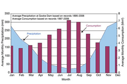
FIGURE 18: Average precipitation inputs and consumption withdrawals from the Sooke Reservoir, southern Vancouver Island, British Columbia (from Capital Regional District Water Services, 2007)
Both the CRD and GVRD face the familiar challenge of managing water supplies in the face of rising population, aging infrastructure and changing climate. The Sooke Reservoir on southern Vancouver Island is the main water supply to the CRD. The region's climate is characterized by mild wet winters and warm dry summers. The area's water balance has a winter surplus of 1226 mm during times of reservoir filling and a summer deficit of 138 mm when reservoir drawdown occurs. Thus, there is a natural mismatch between water supply and water use in the region (Figure 18), as is common for many watersheds in coastal BC. Also, there is considerable inter-annual and inter-decadal variability in seasonal precipitation, with periods of water surplus and extreme water shortages being common since the early 1980s (Figure 19). The PDO significantly influences this variability and the reservoir's water budget (Figure 19).
FIGURE 19: Winter (October-March) and summer (April-September) departures of Sooke Reservoir water supply variables relative to 1961-1990 mean values (linear trends over the 87-year period provided in brackets; * signifies trends significant at the 0.05 level). Temperature, precipitation and consumption data provided by the Capital Regional District. Note that 1966- 1994 temperature and 1971-1977 consumption values are estimates. Evaporation was estimated using day length and air temperature (per Hamon, 1963). Future temperature, precipitation and precipitationevaporation values for 30-year periods centred on the 2020s, 2050s, and 2080s are also shown. Projections are based on ensemble averages for the A2 and B2 emissions scenarios using the seven global climate models recommended by the Intergovernmental Panel on Climate Change (2001))
In response to severe droughts and expected continued population growth, the CRD raised the level of the Sooke Reservoir by 6 m in 2002, increasing storage capacity by 78% (Capital Regional District Water Services, 2004). Based on historical climate conditions and a maximum growth rate of approximately 1%, the expanded reservoir capacity will only meet projected demands until 2023 (Capital Regional District Water Services, 2004). The CRD has implemented several conservation and demand-management initiatives, including residential water metering, multi-stage lawn watering restrictions and rebates for high-efficiency equipment (toilets, washing machines), to offset the demand increase.
The GVRD's water supply comes from the Capilano, Seymour and Coquitlam watersheds, located in the Coast Mountains along the northern fringe of the city. These watersheds have a much wetter and colder climate than Sooke, with significant runoff occurring in spring and fall, and snow accumulation during winter. There is large storage capacity during the summer in six mountain reservoirs. Current constraints on GVRD water supply are associated with the ability of system infrastructure, specifically pipelines, water intakes and water treatment facilities, to meet rising demand from an increasing population.
In future, climate change will result in a decreased snow pack as a greater proportion of annual precipitation falls as rain. In conjunction with longer drier summers, infrastructure will be further stressed, especially during periods of peak seasonal demand. Climate change will likely advance the time when upgrades and capital investments are required for additional storage capacity. Demand management and water conservation programs are important first steps and should help delay the timing of capacity upgrades. The GVRD's Drinking Water Management Plan (DWMP) does include provisions for ongoing assessment and monitoring, including biennial progress reports that consider the potential impacts of climate change on supply and the implications for capacity upgrade planning (Greater Vancouver Regional District, 2005a, b).
Both of BC's principal metropolitan areas have already taken steps to anticipate some impact of climate change on water supplies. These impacts will increase the pressure of rising populations and demand, and effectively bring forward the date when current supplies will be insufficient. Ongoing conservation and demand management represent key adaptation strategies, even if they are not explicitly implemented as such. Longer term adaptation actions are likely to involve further infrastructure upgrades and increased storage capacity.
4.4.2 Stormwater Management
Since 2000, the Greater Vancouver Regional District (GVRD) has been examining the potential risks from climate change on sewer and drainage infrastructure. Trend analysis of more than 40 years of rainfall data indicated an increase in the frequency of extreme rainfall events, such that the recurrence interval of 25 years for an extreme event (4% probability in any given year) had decreased to about 10 years (10% probability; Jakob et al., 2003). Research concluded that observed increases in the frequency of intense rainfall could be correlated with the 1976 phase shift of the PDO. As the present methodology used to generate the rainfall intensity-duration curves for sewer design and stormwater management does not explicitly take into account climate oscillations, it remains possible that rainfall intensity-duration curves could be over- or underestimated, depending on when the majority of rainfall data were collected.
Jakob et al. (2003) also noted that statistically measurable increases in the non-extreme rainfall intensity and volume were evident, and they interpreted these to relate to larger scale climate change. Such increases, although not impacting sewer design, are anticipated to negatively impact the health of urban streams and their populations of salmon and trout. These impacts are similar to those from urbanization and the associated construction of hard surfaces (roofs, roadways, etc). The Water Balance Model for Canada, and the GVRD's design guidelines for stormwater source controls (Lanarc Consultants, 2005) were developed as tools for GVRD municipalities to address the effects of urbanization and climate change on urban streams (Hicks and von Euw, 2004). These represent a first step in the explicit recognition and inclusion of observed and future climate change impacts on urban infrastructure in BC. A pracitioner's perspective on this issue and the role of risk management approaches are presented in Box 3.
BOX 3
Climate change and risk management: a practitioner's perspective
(Robert Hicks, P.Eng., Member, British Columbia Water and Waste Association, Water Sustainability Committee)
Fundamental to local governments is the provision of basic services to their communities. Core services include potable water supplies, streets and roads, and land-use planning, while more comprehensive services include libraries, public housing, and parks and recreation. Municipalities and regional districts form the basis for local governments in British Columbia. 'Improvement districts' effectively form another level of local governance that provides limited function-specific services, such as rural water distribution, flood protection and dyking.
Significant obstacles to climate change adaptation arise from the competition for funding between short-term priorities and long-term risk management. For any community experiencing pressures on a limited tax base or facing significant core infrastructure costs, it is questionable whether there would be the financial means or will to address climate change impacts as a priority. The weighing of priorities is further complicated by difficulties in quantifying the long-term benefits of climate change adaptation programs and/or by the lack of understanding of climate change issues.
Risk Management
Although local governments face challenges in addressing climate change adaptation as a stand-alone issue, they are experienced risk managers, particularly with respect to the provision of their utility services and maintaining their capital assets (roads, bridges, buildings, pipelines). The life cycles of roads, sewer and water systems, and community buildings range from 20 years to a century or more. Such assets are managed with respect to risk of service interruption, level of performance, control of operating costs, and planning and budgeting for replacement and renewal. It is through this context that local governments are well situated to address impacts from climate change as an additional risk related to their provision of municipal services.
Addressing climate change risks related to land use and zoning is more challenging for local governments. It is possible that some proactive adaptation responses might exceed municipal mandates and be difficult to implement. Without compelling justification, local governments are unlikely to implement programs and zoning changes that would adversely affect the value or utility of private lands.
Climate change impact awareness and skills are needed for climate change adaptation to be effectively integrated into day-to-day local government planning and risk management processes. The use of return periods –– commonly used to describe technical design thresholds and performance targets for stormwater, drainage, sewers and water supply systems –– create a false sense of understanding, as they are based upon past events. Return periods are common in regulations and in 'standard engineering practice'. However, using return periods without considering their response to climate variability and climate change is like 'driving a car through the rear-view mirror, it only works if the path is linear'. Consequently, the use of return periods could result in poor long-term decision-making and prevent proactive adaptation if not put into the context of climate change.
Page details
- Date modified: