
Crop Type Mapping
Background
Identifying and mapping crops is important for a number of reasons. Maps of crop type are created by national and multinational agricultural agencies, insurance agencies, and regional agricultural boards to prepare an inventory of what was grown in certain areas and when. This serves the purpose of forecasting grain supplies (yield prediction), collecting crop production statistics, facilitating crop rotation records, mapping soil productivity, identification of factors influencing crop stress, assessment of crop damage due to storms and drought, and monitoring farming activity.
Key activities include identifying the crop types and delineating their extent (often measured in acres). Traditional methods of obtaining this information are census and ground surveying. In order to standardize measurements however, particularly for multinational agencies and consortiums, remote sensing can provide common data collection and information extraction strategies.
Why remote sensing?
Remote sensing offers an efficient and reliable means of collecting the information required, in order to map crop type and acreage. Besides providing a synoptic view, remote sensing can provide structure information about the health of the vegetation. The spectral reflection of a field will vary with respect to changes in the phenology (growth), stage type, and crop health, and thus can be measured and monitored by multispectral sensors. Radar is sensitive to the structure, alignment, and moisture content of the crop, and thus can provide complementary information to the optical data. Combining the information from these two types of sensors increases the information available for distinguishing each target class and its respective signature, and thus there is a better chance of performing a more accurate classification.
Interpretations from remotely sensed data can be input to a geographic information system (GIS) and crop rotation systems, and combined with ancillary data, to provide information of ownership, management practices etc.
Data requirements
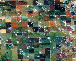
Crop identification and mapping benefit from the use of multitemporal imagery to facilitate classification by taking into account changes in reflectance as a function of plant phenology (stage of growth). This in turn requires calibrated sensors, and frequent repeat imaging throughout the growing season. For example, crops like canola may be easier to identify when they are flowering, because of both the spectral reflectance change, and the timing of the flowering.
Multisensor data are also valuable for increasing classification accuracies by contributing more information than a sole sensor could provide. VIR sensing contributes information relating to the chlorophyll content of the plants and the canopy structure, while radar provides information relating to plant structure and moisture. In areas of persistent cloud cover or haze, radar is an excellent tool for observing and distinguishing crop type due to its active sensing capabilities and long wavelengths, capable of penetrating through atmospheric water vapour.
Canada vs. International
Although the principles of identifying crop type are the same, the scale of observation in Europe and Southeast Asia is considerably smaller than in North America, primarily due to smaller field parcel sizes. Cloud cover in Europe and tropical countries also usually limits the feasibility of using high-resolution optical sensors. In these cases high-resolution radar would have a strong contribution.
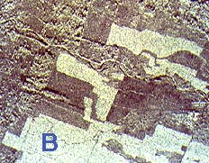
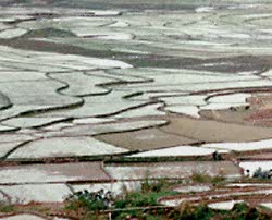
The sizable leaves of tropical agricultural crops (cocoa, banana, and oil palm) have distinct radar signatures. Banana leaves in particular are characterized by bright backscatter (represented by "B" in image). Monitoring stages of rice growth is a key application in tropical areas, particularly Asian countries. Radar is very sensitive to surface roughness, and the development of rice paddies provides a dramatic change in brightness from the low returns from smooth water surfaces in flooded paddies , to the high return of the emergent rice crop.
Case study (example)
The countries involved in the European Communities (EC) are using remote sensing to help fulfil the requirements and mandate of the EC Agricultural Policy, which is common to all members. The requirements are to delineate, identify, and measure the extent of important crops throughout Europe, and to provide an early forecast of production early in the season. Standardized procedures for collecting this data are based on remote sensing technology, developed and defined through the MARS project (Monitoring Agriculture by Remote Sensing).
The project uses many types of remotely sensed data, from low resolution NOAA-AVHRR, to high-resolution radar, and numerous sources of ancillary data. These data are used to classify crop type over a regional scale to conduct regional inventories, assess vegetation condition, estimate potential yield, and finally to predict similar statistics for other areas and compare results. Multisource data such as VIR and radar were introduced into the project for increasing classification accuracies. Radar provides very different information than the VIR sensors, particularly vegetation structure, which proves valuable when attempting to differentiate between crop type.
One the key applications within this project is the operational use of high resolution optical and radar data to confirm conditions claimed by a farmer when he requests aid or compensation. The use of remote sensing identifies potential areas of non-compliance or suspicious circumstances, which can then be investigated by other, more direct methods.
As part of the Integrated Administration and Control System (IACS), remote sensing data supports the development and management of databases, which include cadastral information, declared land use, and parcel measurement. This information is considered when applications are received for area subsidies.
This is an example of a truly successfully operational crop identification and monitoring application of remote sensing.
Page details
- Date modified: