
National Topographic System Maps
Topographic map coverage of Canada is based on the National Topographic System (NTS). These maps depict in detail ground relief (landforms and terrain), drainage (lakes and rivers), forest cover, administrative areas, populated areas, transportation routes and facilities (including roads and railways), and other man-made features.
A 1:50 000 scale topographic map
This is ideal for recreational activities such as cycling, canoeing, snowmobiling, fishing, camping and hiking. Accurately shown are hills, valleys, lakes, rivers, streams, rapids, portages, trails, wooded areas, major, secondary and side roads including all man-made features such as buildings, power lines, dams and cut lines. A 1:50 000 scale map covers an area approximately 1,000 square kilometres.
Levels of government as well as private business use maps at this scale for flood control, forest fire control, real estate planning, development of natural resources, environmental issues, right-of-way, highway planning, and depiction of crop areas. In fact, maps at the 1:50 000 scale can be used for almost any conceivable requirement.
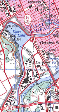
1:50 000 National Topographic System map sample - 031G05 Ottawa, Ontario
A 1:250 000 scale topographic map
This is considered to be a reconnaissance-type map. It covers the same area of land as sixteen 1:50 000 scale maps. This scale is popular not only as a detailed overview of a large area, but also as a detailed road map for use when travelling on back roads and side roads. A full 1:250 000 scale map shows an area approximately the size of Prince Edward Island.
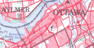
1:250 000 National Topographic System map sample - 031G Ottawa, Ontario
A 1:50 000 scale monochrome map
Meanwhile, vast sections of Canada's northern regions are sparsely populated, if at all. Monochrome (black and white) maps have been produced for many of these areas. The 1:50 000 scale monochrome map provides the same detailed depiction of the landmass as the 1:50 000 scale polychrome (colour) map.
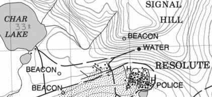
1:50 000 National Topographic System map sample - 058F11 Resolute, Nunavut
Feature types on a polychrome topographic map
On a polychrome map, each feature is represented by a colour. Here is a breakdown of colour meanings:
- Black: buildings, railways, power transmission lines, geographical names (toponymy), certain symbols, geographic coordinates, precise elevations, border information, and surround information
- Red: paved roads, highway numbers, interchange exit numbers, certain symbols, names of major transportation routes and a red tint for urban development
- Orange: unpaved roads and unclassified roads and streets
- Brown: contour lines, spot elevations, sand and eskers
- Blue: lakes, streams, falls, rapids, swamps and marshes, names of bodies of water and watercourses, magnetic declination and UTM (Universal Transverse Mercator) grid information
- Green: wooded areas, orchards, and vineyards
- Grey: on the back of the map for a glossary of terms, and abbreviations
Note: Purple can be used to show information added over the original map detail (updates).
Find out more
Page details
- Date modified: