Topographical Map Grids are Changing
by Gordon Haggert
This article originally appeared in the May 1999 edition of "Canews", (the Magazine of the Ontario Recreational Canoeing Association). Reprinted with permission.
On a trip in the Algoma District our group was trying to identify exactly where we were on a long shoreline using triangulation and comparing our grid references. When looking at two maps we realized the grids on our Canadian 1:50 000 topographic sheets were not in the same positions. The maps appeared the same but the grid lines had shifted by over 200 metres. Was there a misprint on the maps?
Canoe trippers should be aware of what has happened. We were using two editions of the same map. Edition 3 of our map was based on "North American Datum 1927" or "NAD 27" (shown as the Datum Note in the bottom margin of topo maps. Refer to Figure 1.) but Edition 4 of the same map was based on "North American Datum 1983" or "NAD 83".
In 1927 a complete survey of North America was completed to define positions in latitude and longitude and all survey networks which also included the 1000 metre grid pattern that we all have been using on Canadian topo maps. The introduction of navigation satellites has allowed cartographers to define the shape of the earth and the positions of features on the earth more precisely than before. The system as revised in 1983 was officially adopted by the Department of Energy, Mines and Resources (now Natural Resources Canada) in May of 1990. The United States, Mexico, Denmark (Greenland) and Canada had reached agreement on the definition of the datum in 1983, hence the name NAD 83. Other departments of the Government of Canada and provincial governments have adopted NAD 83 as their geodetic reference system for new maps.
NAD 83 is based on the Earth's centre of gravity and also is a more accurate mathematical representation (ellipsoid) of the shape of the earth than was NAD 27. NAD 83 is therefore more compatible with the co-ordinate system used to compute the orbit of satellites used for surveying and for the use of GPS receivers.
The National Topographic System is revising all existing maps to NAD 83 and since April, 1989, all new mapping has been computed using NAD 83 values. Maps not scheduled for revision for a long period of time will not be converted, but instead, will be overprinted with notes, usually in the bottom margin, enabling the conversion of the map grid of the geographic co-ordinates to NAD 83.
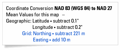
Figure 1 below is an example of a Datum Note. This note informs users of the horizontal and vertical datum’s that coordinates and elevations are based upon. For this example, the vertical datum is "Mean Sea Level" and the horizontal datum is "North American Datum 1927".

This example from the margin of a current map shows that the grid is based on "North American Datum 1927".
Alongside this information is a conversion table to use if you want to know where the new NAD 83 grid would be on a revised map.

The Latitude and Longitude changes slightly but for canoe trippers, you would add 10 m to the Easting and 221 m to the Northing to locate where the new grid lines would be on a NAD 83 map. Any specific map reference point would also move in the same manner. The more up-to-date Canadian topo maps already have printed the NAD 83 grid on them and the co-ordinate conversion is from NAD 83 to NAD 27. On the chart the WGS 84 designation means World Geodetic System 1984 which is consistent with the NAD 83 reference system and used in orbit computation of satellites in the Global Positioning System.
Fortunately for canoe trippers or for map reading classes, confusion can be avoided by everyone in the group using the same edition of the map. Conversions of co-ordinate references from NAD 27 maps to NAD 83 maps (or from NAD 83 maps to NAD 27) are possible if you have the NAD shift information from Natural Resources Canada, or if it is printed in the map margin.
Each map in each of 50 different zones across Canada can be converted using different values. You may want to learn more on the Geodetic Survey's home page and related sites: Canadian Spatial Reference System. The maps at the 1:250 000 scale have been adjusted to more accurately show positions of features but the differences are not measurable at the 1:250 000 scale and therefore changes in grids have not been applied to the maps.
Many maps for canoeists and hikers in the United States show only tick marks in the margin indicating the 1,000 m grid so that users have to join the tick marks for practical purposes. Canoe trippers in Canada can enjoy the usefulness of the completely printed grid and by being aware that the conversions are being made as time goes on.
You may contact Gordon Haggert, Past President of the Ontario Recreational Canoeing and Kayaking Association (ORCKA), at this following address: ghaggert@mnsi.net.
Find out more
- Universal Transverse Mercator Projection
- Rectangular Grid References
- Civilian UTM Grid Reference
- Military Grid Reference System
- Military Grid Reference System - US Defense Mapping Agency's Technical Manual 8358.1
Page details
- Date modified: