
Forestry Applications
There is an ongoing need to understand and quantify the state and dynamics of forests both regionally and globally. Required information includes forest type mapping, identification of clear cuts, and recent burns, and the extraction of a variety of biophysical parameters such as total biomass and tree age.
Use of polarimetric data is anticipated to improve the detection of structural differences between forest canopies and thus to help in forest type mapping and provision of additional information for other forest management applications. Figure 9-26, a multi-polarization false color composite of an area east of Ottawa, illustrates the increased information content for forest identification.
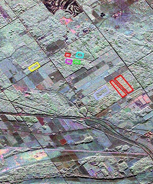
Figure 9-26. . False colour composite image of the Mer Bleue study site near Ottawa , showing six forest areas with different species composition (C-SAR data, Red: HH, Green: HV and Blue: VV).Courtesy of CCRS.
Page details
- Date modified: