
InSAR Measurements of Terrain Stability in Canada's North
Available in PDF format (334 Kb)
Naomi Short, Brian Brisco, Kevin Murnaghan
Canada Centre for Remote Sensing, Earth Sciences Sector, Natural Resources Canada
Successfully used around the world to measure surface movement related to earthquakes, volcanoes and subsiding cities, satellite interferometric synthetic aperture radar, or satellite InSAR, is now a well-established method for accurately measuring displacement of the Earth’s surface from space. Scientists at CCRS are extending this technique by smartly combining new satellite technology and multi-platform experiments to help monitor terrain stability in Canada’s North. These new spaceborne measurements will be a powerful tool to assist the siting and design of new infrastructure in the north, as well as highlighting the risk to existing structures.
The Issue
In Canada’s North, people reside, work and travel on terrain often underlain by frozen soil or permafrost. The seasonal freeze and thaw of the surface active layer leads to cyclical subsidence and heave, which represents a significant challenge to the design and maintenance of northern infrastructure. Today, as the Arctic warms and permafrost degrades, there is an increased urgency to understand this change and give Northerners the tools to adapt.
Scientists at the Canada Centre for Remote Sensing have been working for three years to advance the processing of satellite radar data to measure the stability of terrain in Canada’s permafrost zones. It is their hope that satellite InSAR can reliably measure the seasonal and year-to-year displacements of the ground with the aim of assisting geologists, engineers, biologists and local communities to further understand the seasonal and long term stability of land in the North.
The Science - How it Works
Using a pair of SAR images acquired over the same location at different times, InSAR techniques measure small changes in the phase of a ground target’s returned signal. This change in phase is used to estimate the displacement of the ground target towards or away from the satellite over that acquisition period. By accounting for the uncertainty in this measurement (e.g. atmospheric noise) and relating this line-of-sight displacement to horizontal or vertical terrain movement, CCRS scientists are now able to produce terrain stability maps that are noteworthy and generating interest among permafrost scientists and northern stakeholders.
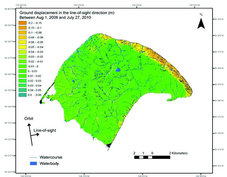
Ground movement over Herschel Island, Yukon, measured over a one year period by RADARSAT-2 InSAR. The highly unstable north-east coast, where coastal erosion is weakening the permafrost, is clearly delineated, as well as other areas of instability on the island, some of which were not previously known.
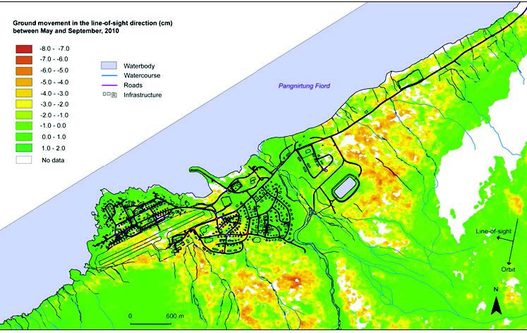
Ground movement for Pangnirtung, Nunavut, determined from RADARSAT-2 InSAR between May and September 2010. The patterns of ground movement are closely aligned with the local surficial geology. Bedrock and the central area of well drained alluvial deposits are more stable than the surrounding tills and marine sediments which contain ground ice. The stabilizing effects of construction can also be seen in the gravel embankments around the water reservoir.
Applying this Technology in Canada’s North
CCRS has focused much of its InSAR research and validation efforts on Herschel Island, Yukon Territory (Figure 1). As the technique matured, scientists applied it to another northern site with different challenges - the community of Pangnirtung, Nunavut (Figure 2). Working with McGill University and GSC permafrost scientists, CCRS is continuing to validate and refine the technique for northern environments. The use of InSAR by CCRS will play a central role in monitoring highway stability within the TRACS initiative led by the Climate Change Geoscience Program. Also, a number of InSAR-based terrain stability maps are currently in production for other northern communities and development areas. With their rapid revisit capabilities, the upcoming Sentinel 1 and RADARSAT SAR constellation missions are expected to enhance and further advance the operational use of this technology for monitoring terrain stability in the North.
Future Directions
CCRS scientists continue to work with fellow ESS researchers to further improve the use of InSAR, not only for permafrost monitoring, but also in the context of other applications such as geohazard monitoring (e.g. landslides) and monitoring extraction-related subsidence in the Alberta oilsands.
Acknowledgements
Anne-Marie Le Blanc and Nicole Couture (GSC), Wayne Pollard (McGill University) and Paul Budkewitsch (Nunavut Geoscience Office).
This work was generously supported by the Canadian Space Agency's Government Related Initiatives Program (GRIP).
For more information, please contact:
Naomi Short, Environmental Scientist Canada Centre for Remote Sensing Earth Observations and GeoSolutions Division
Page details
- Date modified: