
Fire monitoring and reporting tool
The Fire Monitoring, Accounting and Reporting System (FireMARS) is a complex, leading-edge system developed at Natural Resources Canada by the Canadian Forest Service and the Canada Centre for Mapping and Earth Observation (formerly the Canada Centre for Remote Sensing), with support from the Canadian Space Agency.
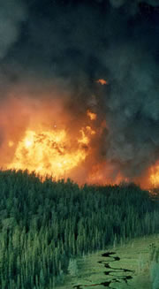
A crown fire in Ontario’s boreal forest.
Photo: Brian Stocks
FireMARS provides:
- burned area polygons mapped nationally on an annual basis through the integration of data from fine and coarse spatial resolution satellite data with provincial/territorial agencies
- an annual contribution to Canada’s National Forest Carbon Monitoring, Accounting and Reporting System (NFCMARS) that calculates greenhouse gas emissions and removals from Canada’s managed forests. These estimates serve as input to Canada’s annual National Greenhouse Gas Inventory report to meet Canada’s international greenhouse gas reporting requirements
FireMARS includes four key components:
- The National Burned Area Composite (NBAC) has been used to map burned areas in Canada since 1986.
- The Canadian Wildland Fire Information System (CWFIS) monitors daily fire weather and fire behaviour conditions across Canada.
- The Canadian Fire Effects (CanFIRE) model estimates carbon emissions from combustion.
- The Carbon Budget Model of the Canadian Forest Sector (CBM-CFS3) models carbon stocks, carbon stock changes, and emissions and removals of greenhouse gases from Canada’s forests.
.jpg)
![Larger image [864 kb]](/sites/nrcan/files/forest/FireMonitoring/Canada_NBAC_1986_2022_800_en.png)
Burned areas mapped annually from the National Burned Area Composite since 1986.
Fire releases significant amounts of carbon and greenhouse gases from Canada’s forests each year. In extreme years, carbon emissions from wildland fires across the country approach the level of emissions from all fossil fuel sources.
With forest fire frequency and severity expected to increase in a changing climate, it is especially important to measure and monitor carbon emissions from fire. NBAC data, fine and coarse spatial resolution satellite data and data from provincial and territorial agencies, are used for estimating emissions in Canada’s National Forest Carbon, Monitoring, Accounting and Reporting System.
Page details
- Date modified: