
Current wildland fire activity - the CWFIS
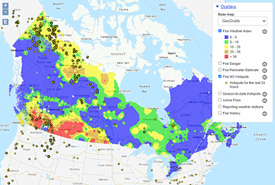
View current wildland fire conditions on the CWFIS interactive map.
The Canadian Wildland Fire Information System (CWFIS) monitors fire conditions and occurrences across Canada. Since 1994, it provides daily national-level wildland fire maps, reports and a wide range of data products and services.
This information is used by:
- the Canadian Interagency Forest Fire Centre (CIFFC)
- municipal, provincial, territorial and federal agencies
- Indigenous communities
- industries, including agriculture, forestry, hydroelectric power, insurance, transportation, etc.
- academia and other researchers
- the media and the public.
Stay informed
Daily information
To create daily fire weather, fire behaviour and fire occurrence maps, the CWFIS uses:
- weather data from over 2500 weather stations across Canada and the United States
- remote sensing satellite data for fire detection and perimeter estimates
- reported fire location data collected from the provinces, territories and national parks.
Wildfire intelligence and predictive services
The CWFIS gets its data by combining components:
- Canadian Forest Fire Danger Rating System (CFFDRS), a non-spatial system that deals with the prediction of wildland fire potential from a single fire weather station (a “point source”).
- Canadian Forest Fire Weather Index (FWI) system accounts for the effects of fuel moisture and weather conditions on fire behaviour.
- Canadian Forest Fire Behavior Prediction (FBP) system provides quantitative estimates of potential fire spread rate, fuel consumption and fire intensity as well as fire descriptions.
- Fire Monitoring, Mapping, and Modelling (Fire M3), uses low-resolution satellite imagery to find and locate actively burning fires, estimate daily and annual area burned, and model fire behaviour and biomass consumption from fires.
While not designed for operational fire management purposes, the CWFIS provides national wildland fire monitoring and reporting information to Canada’s National Forest Information System.
The Government of Canada has programs, policies and initiatives for informing Canadians about wildland fires and management efforts.
Find out more
Page details
- Date modified: