
Digital Elevation Models
Background
 The availability of digital elevation models (DEMs) is critical for performing geometric and radiometric corrections for terrain on remotely sensed imagery, and allows the generation of contour lines and terrain models, thus providing another source of information for analysis.
Present mapping programs are rarely implemented with only planimetric considerations. The demand for digital elevation models is growing with increasing use of GIS and with increasing evidence of improvement in information extracted using elevation data (for example, in discriminating wetlands, flood mapping, and forest management). The incorporation of elevation and terrain data is crucial to many applications, particularly if radar data is being used, to compensate for foreshortening and layover effects, and slope induced radiometric effects. Elevation data is used in the production of popular topographic maps.
Elevation data, integrated with imagery is also used for generating perspective views, useful for tourism, route planning, to optimize views for developments, to lessen visibility of forest clearcuts from major transportation routes, and even golf course planning and development. Elevation models are integrated into the programming of cruise missiles, to guide them over the terrain.
Resource management, telecommunications planning, and military mapping are some of the applications associated with DEMs.
Why remote sensing?
There are a number of ways to generate elevation models. One is to create point data sets by collecting elevation data from altimeter or Global Positioning System (GPS) data, and then interpolating between the points. This is extremely time and effort consuming. Traditional surveying is also very time consuming and limits the timeliness of regional scale mapping.
Generating DEMs from remotely sensed data can be cost effective and efficient. A variety of sensors and methodologies to generate such models are available and proven for mapping applications. Two primary methods if generating elevation data are 1. Stereogrammetry techniques using airphotos (photogrammetry), VIR imagery, or radar data (radargrammetry), and 2. Radar interferometry.
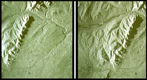
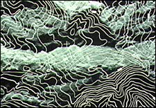
Stereogrammetry involves the extraction of elevation information from stereo overlapping images, typically airphotos, SPOT imagery, or radar. To give an example, stereo pairs of airborne SAR data are used to find point elevations, using the concept of parallax. Contours (lines of equal elevation) can be traced along the images by operators constantly viewing the images in stereo.
The potential of radar interferometric techniques to measure terrain height, and to detect and measure minute changes in elevation and horizontal base, is becoming quickly recognized.
Interferometry involves the gathering of precise elevation data using successive passes (or dual antenna reception) of spaceborne or airborne SAR. Subsequent images from nearly the same track are acquired and instead of examining the amplitude images, the phase information of the returned signals is compared. The phase images are coregistered, and the differences in phase value for each pixel is measured, and displayed as an interferogram. A computation of phase "unwrapping" or phase integration, and geometric rectification are performed to determine altitude values. High accuracies have been achieved in demonstrations using both airborne (in the order of a few centimetres) and spaceborne data (in the order of 10m).
Primary applications of interferometry include high quality DEM generation, monitoring of surface deformations (measurement of land subsidence due to natural processes, gas removal, or groundwater extraction; volcanic inflation prior to eruption; relative earth movements caused by earthquakes), and hazard assessment and monitoring of natural landscape features and fabricated structures, such as dams. This type of data would be useful for insurance companies who could better measure damage due to natural disasters, and for hydrology-specialty companies and researchers interested in routine monitoring of ice jams for bridge safety, and changes in mass balance of glaciers or volcano growth prior to an eruption.
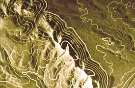
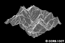
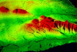
From elevation models, contour lines can be generated for topographic maps, slope and aspect models can be created for integration into (land cover) thematic classification datasets or used as a sole data source, or the model itself can be used to orthorectify remote sensing imagery and generate perspective views.
Data requirements
The basic data requirement for both stereogrammetric and interferometric techniques is that the target site has been imaged two times, with the sensor imaging positions separated to give two different viewing angles.
In virtually all DEM and topographic map generation applications, cartographic accuracy is the important limiting factor. Turnaround time is not critical and repeat frequency is dependent on whether the application involves change detection, and what the temporal scope of the study is.
Canada vs. International
 Aerial photography is the primary data source for DEM generation in Canada for national topographic mapping. For other applications of DEMs, there are additional satellite sources such as SPOT, with its pointable sensors and 10m panchromatic spatial resolution, producing adequate height information at scales smaller than 1:50,000.
The height accuracy requirement for 1:50,000 mapping in Canada is between 5 and 20 m. In developing countries it is typically 20 m. The original elevation information used in the Canadian National Topographic Series Maps was provided from photogrammetric techniques.
In foreign markets, airborne radar mapping is most suited for approximately 1:50,000 scale topographic mapping. Spaceborne radar systems will be able to provide data for the generation of coarser DEMs through radargrammetry, in areas of cloud cover and with less stringent accuracy requirements. Stereo data in most modes of operation will be available because of the flexible incidence angles, allowing most areas to be captured during subsequent passes. Interferometry from airborne and spaceborne systems should meet many mapping requirements.
Did you know?
When you look at a stereo pair of images you perceive a virtual 3D model of the terrain or object that was imaged. Through this 3D virtual terrain model (VTM?), it is possible to extract cartographic information without using a DEM!
Page details
- Date modified: