
Sea Ice
For people living in northern environments, ice is a common phenomenon that affects our local activities. Most of us however, don't consider its larger regional or global implications. Ice covers a substantial part of the Earth's surface and is a major factor in commercial shipping and fishing industries, Coast Guard and construction operations, and global climate change studies. Polar sea ice seasonally covers an even larger area, roughly equal in size to the North American continent, 25 million km².
Its extensive distribution means that sea ice plays a large role in the albedo of the earth. Albedo is a term referring to the measure of reflectivity of the Earth's surface. Ice and snow are highly reflective and changes in their distribution would affect how much solar energy is absorbed by the earth. Under warming conditions, the ice would melt, and less incoming energy would be reflected, thereby potentially increasing the warming trend. The opposite may also be true - an increase of ice due to cooler conditions would reflect even more of the incoming solar energy, potentially propagating even colder conditions. Of course these potential changes in sea ice distribution are of concern to scientists studying global climate change, as are sea ice interactions with the ocean and atmosphere.
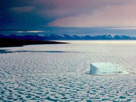
During winter in the northern hemisphere, ice creates a substantial barrier to both lake and ocean going vessels trying to reach ports or navigating along coastlines. Ice floes, pack ice and icebergs create potential hazards to navigation, while landfast ice hinders access to the shore. Ice breakers are often used to create routes for ships to follow from the open water to their ports. In Canada, two important locations for this type of operation are the Gulf of St. Lawrence /Great Lakes and the Canadian Arctic. The Gulf is the main route for international cargo vessels headed for Montreal and Québec, and is affected by ice through the winter and spring. Canada's Arctic is home to mineral and hydrocarbon reserves that require shipping for construction equipment, supplies, and transport of resources to refineries and populated markets. In addition, the main method of re-supply for northern communities is by sea. In both areas, information regarding ice conditions, type, concentration and movement are required.
To address these demands, ice analysis charts, daily ice hazard bulletins, seasonal forecasts, and tactical support for observation are provided. In Canada, the Canadian Ice Service is responsible for acquiring and distributing this information and appropriate products. They also maintain an ice information archive which contains useful data for environmental impact assessments, risk assessment, short-term and seasonal route planning for ships, efficient resource transportation and infrastructure development.
Remote sensing data can be used to identify and map different ice types, locate leads (large navigable cracks in the ice), and monitor ice movement. With current technology, this information can be passed to the client in a very short timeframe from acquisition. Users of this type of information include the Coast Guard, port authorities, commercial shipping and fishing industries, ship builders, resource managers (oil and gas / mining), infrastructure construction companies and environmental consultants, marine insurance agents, scientists, and commercial tour operators.
Examples of sea ice information and applications include:
- ice concentration
- ice type / age /motion
- iceberg detection and tracking
- surface topography
- tactical identification of leads: navigation: safe shipping routes/rescue
- ice condition (state of decay)
- historical ice and iceberg conditions and dynamics for planning purposes
- wildlife habitat
- pollution monitoring
- meteorological / global change research
Did you know?
"...GPS = Good Protection Sidekick..."
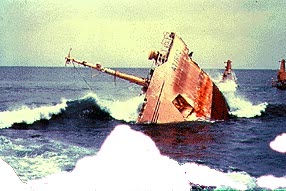
Accidents like the sinking of the Titanic are virtually eliminated now, with iceberg reconnaissance (provided by the International Ice Patrol) and GPS navigation onboard ships. And even if a ship did collide with an iceberg, search and rescue operations using remote sensing and GPS navigation could save many lives in such an incident.
Page details
- Date modified: