
Soil Moisture
Background
Soil moisture is an important measure in determining crop yield potential in Canada and in drought-affected parts of the world (Africa) and for watershed modelling. The moisture content generally refers to the water contained in the upper 1-2m of soil, which can potentially evaporate into the atmosphere. Early detection of dry conditions which could lead to crop damage, or are indicative of potential drought, is important for amelioration efforts and forecasting potential crop yields, which in turn can serve to warn farmers, prepare humanitarian aid to affected areas, or give international commodities traders a competitive advantage. Soil moisture conditions may also serve as a warning for subsequent flooding if the soil has become too saturated to hold any further runoff or precipitation. Soil moisture content is an important parameter in watershed modelling that ultimately provides information on hydroelectric and irrigation capacity. In areas of active deforestation, soil moisture estimates help predict amounts of run-off, evaporation rates, and soil erosion.
Why Remote Sensing?
Remote sensing offers a means of measuring soil moisture across a wide area instead of at discrete point locations that are inherent with ground measurements. RADAR is effective for obtaining qualitative imagery and quantitative measurements, because radar backscatter response is affected by soil moisture, in addition to topography, surface roughness and amount and type of vegetative cover. Keeping the latter elements static, multitemporal radar images can show the change in soil moisture over time. The radar is actually sensitive to the soil's dielectric constant, a property that changes in response to the amount of water in the soil.
Users of soil moisture information from remotely sensed data include agricultural marketing and administrative boards, commodity brokers, large scale farming managers, conservation authorities, and hydroelectric power producers.
Data requirements
Obviously, a sensor must be sensitive to moisture conditions, and radar satisfies this requirement better than optical sensors. Frequent and regular (repeated) imaging is required during the growing season to follow the change in moisture conditions, and a quick turnaround is required for a farmer to respond to unsuitable conditions (excessive moisture or dryness) in a timely manner. Using high resolution images, a farmer can target irrigation efforts more accurately. Regional coverage allows an overview of soil and growing conditions of interest to agricultural agencies and authorities.
Canada vs. International
Data requirements to address this application are similar around the world, except that higher resolution data may be necessary in areas such as Europe and Southeast Asia, where field and land parcel sizes are substantially smaller than in North America.
Case Study (example)
Rainfall distribution , Melfort, Saskatchewan, Canada
As with most Canadian prairie provinces, the topography of Saskatchewan is quite flat. The region is dominated by black and brown chernozemic soil characterized by a thick dark organic horizon, ideal for growing cereal crops such as wheat. More recently, canola has been introduced as an alternative to cereal crops.
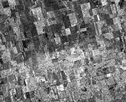
Shown here is a radar image acquired July 7, 1992 by the European Space Agency (ESA) ERS-1 satellite. This synoptic image of an area near Melfort, Saskatchewan details the effects of a localized precipitation event on the microwave backscatter recorded by the sensor. Areas where precipitation has recently occurred can be seen as a bright tone (bottom half) and those areas unaffected by the event generally appear darker (upper half). This is a result of the complex dielectric constant which is a measure of the electrical properties of surface materials. The dielectric property of a material influences its ability to absorb microwave energy, and therefore critically affects the scattering of microwave energy.
The magnitude of the radar backscatter is proportional to the dielectric constant of the surface. For dry, naturally occurring materials, this is in the range of 3 - 8 , and may reach values as high as 80 for wet surfaces. Therefore the amount of moisture in the surface material directly affects the amount of backscattering. For example, the lower the dielectric constant, the more incident energy is absorbed, the darker the object will be on the image.
Did you know?
Another part of the electromagnetic spectrum that has been used for soil moisture measurement is the gamma ray wavelength range. Recording the natural emission of gamma rays from the earth, aircraft carrying gamma ray spectrometers are used to detect the attenuation or alteration by soil moisture, of the intensity of the emanation. The gamma ray wavelength is extremely short - about 10-12 metres in length (!) and the intensity of this natural radiation at the earth's surface is very weak. As a result satellite altitudes are not practical for this form of remote sensing. Even the aircraft used for this purpose must fly as close to the ground as possible.
Page details
- Date modified: