
Structural Mapping & Terrain Analysis
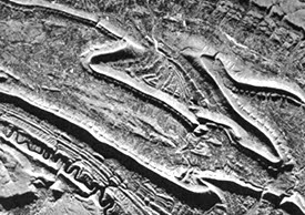
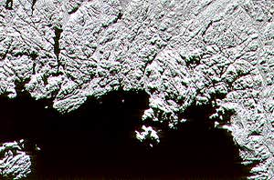
Syncline structures (in Pennsylvania) on SAR imagery
Background
Structural geology plays an important role in mineral and hydrocarbon exploration, and potential hazard identification and monitoring.
Structural mapping is the identification and characterization of structural expression. Structures include faults, folds, synclines and anticlines and lineaments. Understanding structures is the key to interpreting crustal movements that have shaped the present terrain. Structures can indicate potential locations of oil and gas reserves by characterizing both the underlying subsurface geometry of rock units and the amount of crustal deformation and stress experienced in a certain locale. Detailed examination of structure can be obtained by geophysical techniques such as seismic surveying.
Structures are also examined for clues to crustal movement and potential hazards, such as earthquakes, landslides, and volcanic activity. Identification of fault lines can facilitate land use planning by limiting construction over potentially dangerous zones of seismic activity.
Why remote sensing?
A synoptic view of regional scale is a much different perspective than point ground observations when trying to map structural elements. Remote sensing offers this perspective and allows a geologist to examine other reference ancillary data simultaneously and synergistically, such as geo-magnetic information.
Certain remote sensing devices offer unique information regarding structures, such as in the relief expression offered by radar sensors. Comparing surface expression to other geological information may also allow patterns of association to be recognized. For instance, a rock unit may be characterized by a particular radar texture which may also correlate with a high magnetic intensity or geochemical anomaly. Remote sensing is most useful in combination, or in synergy, with complementary datasets.
A benefit of side looking radar is that the illumination conditions can be controlled, and the most appropriate geometry used for type of terrain being examined. Uniform illumination conditions provided by the sun, especially at equatorial latitudes, are usually not conducive to highlighting relief features. An extra benefit of airborne SAR sensors is that acquisition missions can be customized to orient the flightline parallel to the target orientation, to maximize the illumination and shadow effect.
Data requirements
In areas where vegetation cover is dense, it is very difficult to detect structural features. A heavy canopy will visually blanket the underlying formation, limiting the use of optical sensors for this application. Radar however, is sensitive enough to topographic variation that it is able to discern the structural expression reflected or mirrored in the tree top canopy, and therefore the structure may be clearly defined on the radar imagery.
Structural analyses are conducted on regional scales, to provide a comprehensive look at the extent of faults, lineaments and other structural features. Geologic features are typically large (kilometre scale) and applications therefore require small-scale imagery to cover the extent of the element of interest. Aerial photos can be used in temperate areas where large-scale imagery is required, particularly to map potential geohazards (e.g. landslides).
Structural mapping applications generally are not time sensitive (other than for project deadlines!) and so a fast turnaround is not required. Unless a time series analysis of crustal deformation is being conducted, frequency of imaging is not a critical issue either. The key factor for remotely sensed data are that they provide some information on the spatial distribution and surficial relief of the structural elements. Radar is well suited to these requirements with its side-looking configuration. Imaging with shallow incidence angles enhances surficial relief and structure. Shadows can be used to help define the structure height and shape, and thus increasing the shadow effect, while shallow incidence angles may benefit structural analysis.
Canadian vs. International requirements
Requirements for remote sensing parameters of structural features are fairly constant throughout the world. Those areas of persistent cloud cover will benefit from radar imaging, while areas at very high or low latitudes can benefit from low sun angles to highlight subtle relief for optical imaging.
Case study (example): Port Coldwell, Ontario: A case for SAR integration
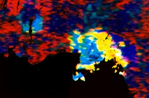
The structural information provided by radar complements other spatial datasets. When integrated together, SAR and spatial geological datasets provide a valuable source of geological information. In this example, radioactivity information of the area of Port Coldwell, Ontario, was provided by an airborne gamma-ray spectrometry survey, which collected potassium, thorium, and uranium readings. This data is informative, but it is difficult to put the information into perspective without the layout and recognizable characteristics of the landscape. Airborne SAR image data was also acquired of the same region. The SAR image is quite interesting in terms of micro-topography and structure, but does not provide any other geo-technical information about the terrain. These two datasets were integrated, using an IHS approach (intensity-hue- saturation to replace the conventional red-green-blue colour display). The airborne gamma-ray spectrometry data are coded as the hue and saturation information, while the SAR terrain information is coded as the intensity information. The resulting integrated image is an excellent display of structural, relief, and natural radioactivity information, allowing a geologist to have a comprehensive view of the data with only one image.
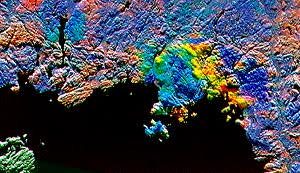
Integrated image (natural radioactivity and SAR) of Port Coldwell
Page details
- Date modified: