
Measure this (Northern Saskatchewan)
Instructions: Inserted in the Landsat satellite image of northern Saskatchewan, is a scale bar (3km) and a North arrow (bottom right of the image). These will help you to answer some of the following questions.
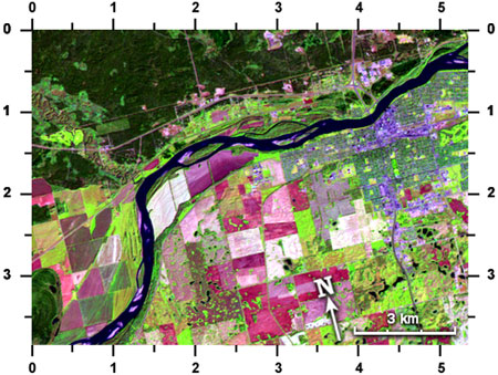
Saskatchewan
Which road is oriented north-south?
The one at:
A: (1.6, 1.2)
B: (3.1, 0.6)
C: (1.4, 3.0)
D: (2.0, 0.5)
E: (1.1, 0.6)
Directly west of (1.6, 3.2) is a small island in the river which is:
A: light pink in colour (no vegetation)
B: green in colour (covered with vegetation)
C: has equal amounts of pink and green
Find the town of Prince Albert (blue/purple) on the south shore of the big river (North Saskatchewan River). Look carefully for the bridge that crosses the river near the town. This bridge is:
A: almost 3 km long
B: more than 1 km long
C: much less than 1 km long
D: D: I can't tell how long without taking a trip there.
If I wanted to take a boat trip along the North Saskatchewan River from where it enters the satellite image to where it exits the image, my trip length would be (a piece of string or a shoelace would help you in this task):
A: 17 km
B: 28 km
C: 14 km
D: 11.4467 km
The very light pink/white field at: (2.6,2.6) has an area of about:
A: between 2 and 3 square kilometres
B: a bit less than 1 square km
C: more than 4 square kilometers
The yellow-green feature at (0.4, 1.3) is a golf course. If you lived in the town of Prince Albert, at (4.4, 1.1) and wanted to drive to this golf course, the distance would be about:
A: 12 km
B: 22 km
C: 8 km
D: 10 km
Page details
- Date modified: