
100 Years of Geodetic Surveys in Canada
This Timeline highlights many significant events from Geodetic Survey Division's 100-year history. In fact geodetic survey work began in Canada over 100 years ago and the Timeline starts in 1872 with "W.F. King's early career".
1872 – 1905: W. F. King's early career
At 18 years old W. F. King joined the Boundary Commission of the Department of the Interior as a sub-assistant astronomer working to establish the 49th parallel. After becoming a Dominion Land Surveyor (DLS) and Dominion Topographical Surveyor in 1876, he was placed in charge of the astronomic observations until 1881, at which time the survey was completed. King advanced rapidly in the Civil Service, becoming Inspector of Western Surveys in 1883, Chief Inspector of Surveys in 1886, Chief Astronomer in 1890, and finally, founding director of the Dominion Observatory in 1905.
1882: DLS Association formed
The association of Dominion Land Surveyors (ADLS) was formed on April 24, 1882, with Otto J. Klotz as its first president. Many Dominion Land Surveyors were employed in early geodetic operations. Over the years, many Geodetic Survey Division (GSD) employees were encouraged to pursue DLS, and later Canada Lands Survey (CLS), commissions.
1883: First precise vertical survey
The Department of Public Works commenced precise levelling work from Rouses Point in Quebec following the Richelieu River to Sorel on the St. Lawrence River. The purpose of this work was to provide vertical control for harbours and river improvements.
1885: Astro control for Survey of the B.C. Railway Belt
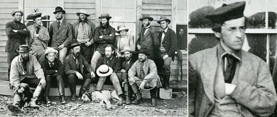
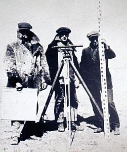
By the Settlement Act of 1883, British Columbia ceded to the Dominion Government a belt of land extending 20 miles on each side of the Canadian Pacific Railway line. This necessitated a survey of the lands within the Belt, and began with the measurement of an accurate traverse of the railway right-of-way in 1885 under the direction of William Ogilvie. O.J. Klotz and T. Drummond were assigned the task of determining very precise latitude and longitude positions by astronomic observations at points along the railway line.
1886 – 1909: Pressure for creation of a Geodetic Survey
As early as 1886 groups began to pressure the Canadian government to create a national geodetic survey: Dominion Land Surveyors Association (in 1886), a DLSA-appointed committee which included W.F. King and O.J. Klotz (in 1888), Royal Society of Canada (in 1894 and 1903), Canadian Society of Civil Engineers (in 1906).
1902: First precise gravity measurements
The first precise gravity measurements in Canada were made by O.J. Klotz using a Mendenhall pendulum apparatus. He performed a series of ties between Ottawa and Washington, as well as making measurements in Montreal and Toronto.
1905: First triangulation station
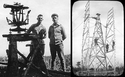
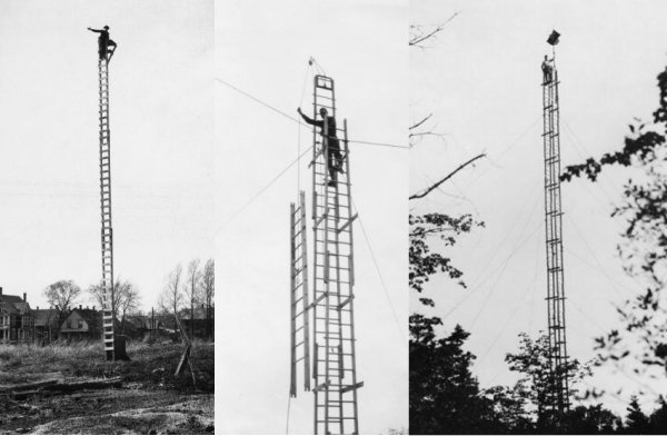
The first geodetic triangulation is started in the Ottawa area by the Dominion Observatories Branch. The first station is established on King Mountain near Kingsmere, Quebec and observation towers are used for the first time.
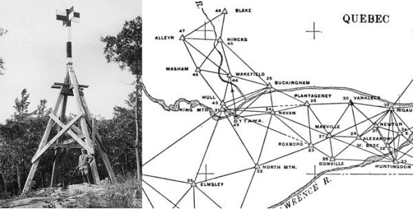
1905: Theodolites and timber towers
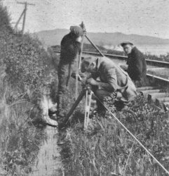
Ponderous theodolites with micrometer circles of 12-inch diameter were used to measure angles for chains of cross-braced quadrilateral figures. Timber towers were built in flat and wooded areas to ensure inter-visibility and long range. An inner tower for the theodolite and an outer for the observer. The typical observing party consisted of a surveyor, a recorder, a cook and 5 or 6 light-keepers.
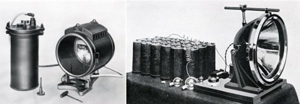
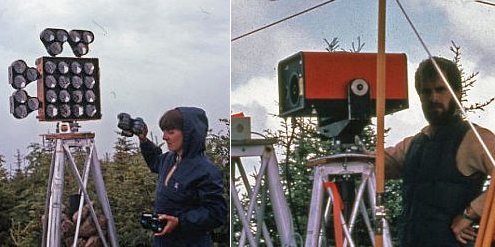
1905: Sighting by lamp
The measurement of angles was usually done at night when atmospheric conditions were most favourable, generally between sunset and midnight. At first, sightings were taken to railway-signal oil lamps with condensing lenses. Later, acetylene lamps (left), similar to the old-style automobile headlight, were used. In 1920, electric lamps (right) were introduced.
1905: W. F. King responsible for all field operations
W. F. King, Chief Astronomer, is ultimately responsible for all field operations of the Astronomy Branch. Work consisted principally of astronomic and geodetic observations and computations.
1906: GSD earliest levelling
The Astronomy Branch begins precise levelling work in Sherbrooke, Quebec. Benchmark number 1 was installed in the stonework of the old Post Office (now the library). Levelling work proceeded westerly along the Canadian Pacific Railway to Kemptville and Prescott then along the Grand Trunk Railway.
1906: Geodetic Levels and wood rods
Precise levelling was done with a level of Untied States (US) Coast and Geodetic Survey pattern. Levelling rods were built up of strips of well-seasoned yellow pine, and, before being painted, were immersed in boiling paraffin in order to minimize the variation in length caused by change of humidity.
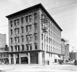
1907: Trafalgar Building
Staff were housed in Trafalgar Building in downtown Ottawa (corner of Bank and Queen)
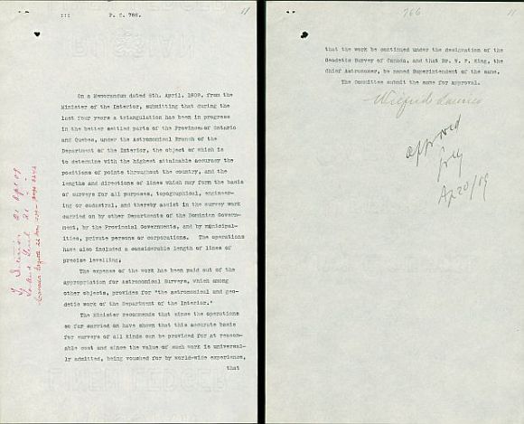
1909: Geodetic Survey of Canada
Geodetic Survey was officially established by Order-in-Council P.C. 766 signed by Prime Minister Sir Wilfrid Laurier on April 20, 1909.
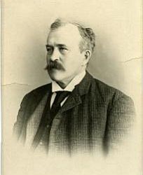
1909 – 1916: Dr. W.F. King
William Frederick King, Chief Astronomer, Boundary Commissioner and Superintendent of Geodetic Survey 1909-1916
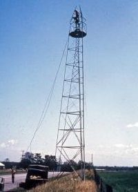
1911: Tall observing towers
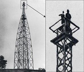
Construction of a standard 110-foot wooden observing tower required about 8,250 board feet of lumber. This 110-foot tower erected near Chatham, Ontario in 1911, with a lamp stand extended 37 feet, reached a height of 147 feet (45 metres). Where high towers were required, the building party consisted of a foreman, an assistant, five carpenters and a cook.
1913: North American Datum (NAD)
In 1913 Canada and Mexico adopt the 1901 U.S. Standard Datum for triangulation. Based on the Clarke 1866 ellipsoid, its starting point is the geodetic station at Meade's Ranch, Kansas and its orientation is given by the azimuth from Meade's Ranch to station Waldo. As a result of this adoption, the datum was renamed the North American Datum.
1914: Coast watchers
After the outbreak of World War I in 1914, GSD triangulation parties working in the Dixon Entrance on the west coast of British Columbia were able to render assistance to the naval authorities in the Prince Rupert area. Field parties occupying prominent hills scattered among the outlying islands could keep one eye out for German cruisers which were in the vicinity. The acetylene lamps used as target lights in measuring angles also served for sending messages by Morse code through the network of interconnecting survey points to the authorities in Prince Rupert.
1914: New Geodetic Survey Building
In 1914, the Geodetic and Boundary Surveys move into the newly completed Geodetic Survey Building, built adjacent to the Dominion Observatory on the grounds of the Experimental Farm.
1914 – 1915: First gravity network
Not since 1902 had any further gravity observations been made until 1914 when F.A. McDiarmid made a tie between Ottawa and Washington, as well as occupying 18 field stations across south central Ontario and western Quebec. In 1915 he observed a further 24 stations spread between New Brunswick and British Columbia, thus completing a Canada-wide line of gravity stations.
1916: Transcontinental Levelling line
The first Canadian transcontinental line of levels was completed. It connected to 5 tide gauges: Halifax, Yarmouth and Pointe-au-Père on the Atlantic and Vancouver and Prince Rupert on the Pacific. 94% of the levelling line was done along railroad tracks.
1916: Geodetic Survey Branch
Following Dr. Kings death in 1916, Geodetic Survey became independent of the Astronomy Branch.
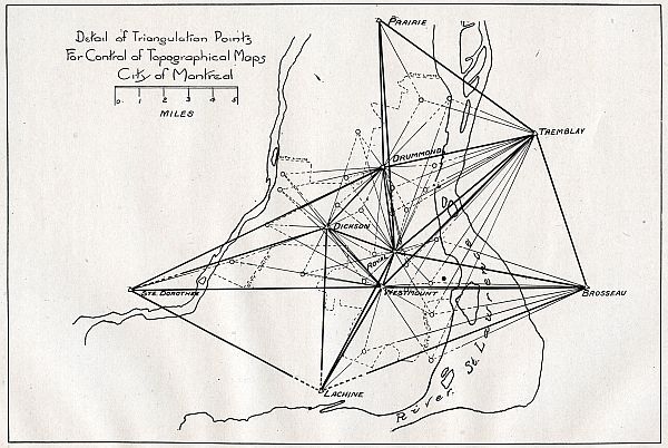
1917: Municipal Surveys
Triangulation and levelling surveys in Montreal and Toronto followed by similar projects in London, Quebec, Halifax, St. John, Vancouver and New Westminster.
1917 – 1946: Noel J. Ogilvie
Noel J. Ogilvie was appointed as Superintendent. Born in Hull in 1880, he was related to William Ogilvie of Yukon fame. In 1923, his title was changed to Director.
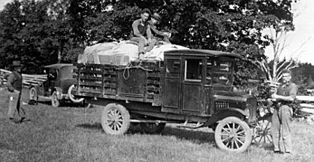
1919: Use of motor trucks for geodetic work
In the 1919 Annual Report of the Superintendent, Noel Ogilvie recommends the use of motor trucks instead of horses and wagons for transportation on geodetic operations, citing the economy of time and money.
1919: Reconnaissance tower
To make triangulation stations intervisible it was often necessary to erect observing towers whose heights could vary from 20 feet to 150 feet depending on the topography. In flat, partly timbered areas as well as in city triangulation portable reconnaissance towers were used to help determine the height required for the observations tower to be built. Reconnaissance towers proved to be quite useful, economical and often indispensable.
1921: Precise traverse
The first precise traverse, some 120 kilometre (km) long, was run in the Niagara district, the distances being measured by invar tapes laid flat on the ground.
1921: Aircraft
Aerial reconnaissance for geodetic triangulation was used for the first time by Mr. F.H. Lambart in 1921. A 200-mile long triangulation net following the Fraser River was flown eastward from Vancouver and the results were confirmed by ground visits to the stations. However, it was not until 1929 that airplanes were widely employed for geodetic surveying in Canada. Air journeys totalling 35 000 kilometres were made during that field season.
1922: Automatic time switch
Electric lamps had been in use as triangulation target lights since 1920 when, in 1922, automatic time switches were introduced. The clock wound switches turned the signal lamps on and off at predetermined times, thus reducing the number of light-keepers needed to tend the target lights. An estimated saving of $3000 was achieved in the first season of field work.
1925: Invariable (INVAR) rods
The earlier wooden rods had been replaced in 1925 by rods of Invar (short for "invariable"). Made up of 36% nickel and 64% iron, INVAR exhibits the least amount of thermal expansion of any alloy know.
1925: Relevelling for Geodynamics
Relevelling was done for the detection of earth movement following a serious earthquake in the vicinity of Montmagny, Quebec. Most earthquakes occur under the St. Lawrence River, between Charlevoix County on the north shore and Kamouraska County on the south shore. 100 km downstream from Quebec City, this region, often referred to as the Charlevoix-Kamouraska Seismic Zone, is the most seismically active region of eastern Canada.
1925: Central Archive
A Central Bureau of Geographic Positions and Elevations was established in the Survey to facilitate the provision of a comprehensive set of records of control surveys done by Geodetic Survey and by other federal departments, provincial departments, railway companies and private corporations.
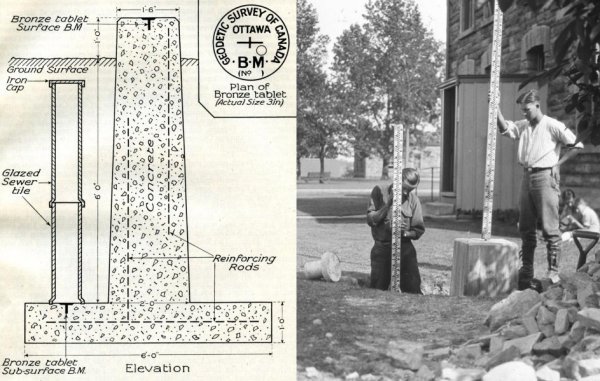
1926: Fundamental Benchmark
A new type of monument known as "fundamental benchmark" was built in cities and important junctions. Although only 12 to 15 inches was visible above ground these were sizeable monuments requiring a large escavation. A 7-foot tall reinforced concrete column rested on a circular base 6 feet in diameter. One bronze tablet served as a surface BM to be used by the public and had a published elevation. In case this tablet or the top portion of the monument became damaged a second tablet known as the "sub-surface" BM was set in the base beside the column. It was covered by 2 sewer tiles topped by an iron cap which sat a foot below gorund surface. It's elevation was not published but, if the necessity arose, the "sub-surface" BM could be recovered by officers of the Geodetic Survey to re-establish a surface BM.
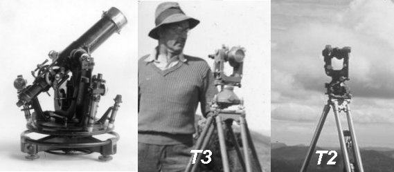
1927: Wild T3
When the Wild T2 Universal Theodolite first appeared in 1924, its revolutionary design caught the attention of J.L. Rannie of the GSD. The T2 was small and lightweight (5.6 kg) compared to the old large 300 mm theodolites which had to be packed in two huge boxes. While the precision of its angle-reading system was not a factor, its telescope aperture was too small for the long lines observed on geodetic triangulation. It was mainly as a result of suggestions by Rannie that Wild designed a slightly larger theodolite (11.2kg) with a telescope of increased aperture, the T3 precision Theodolite. It was adopted by GSD in 1927 as the workhorse for triangulation work and by 1929, twelve instruments were in use. The T3 continued to be employed by GSD into the late 1980s, specifically on high precision trilateration work.
1927: Deflections of the plumb line
Prior to 1927, all astronomical observations made by GSD were for Laplace azimuth determinations, but in 1927 astronomy field parties began observing latitude and longitude at triangulation points in order to determine values for the deflection of the plumb line at those stations. The broken-telescope type Heyde transit replaced the old straight telescope transit. The Heyde instrument in its two packing cases could be easily transported by canoe, pack horse, airplane or back pack.
1927: North American Datum of 1927 (NAD27)
In 1927 and the following years a readjustment of all the triangulation in Canada and the United States was performed. As with NAD (1913) this adjustment was based on the Clarke 1866 ellipsoid and the geodetic station at Meades Ranch but with a corrected azimuth to station Waldo. The latitude and longitude of Meades Ranch remained the same and Clarke's spheroid of 1866, which proved to fit North American continent, was used again. The datum is called the North American Datum of 1927 (NAD27). Mexico and Guatemala later connected to NAD27.
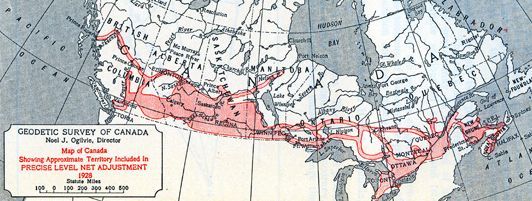
1927 – 1935: Canadian Geodetic Vertical Datum of 1928 (CGVD28)
The readjustment of the Canadian level net was started in 1927 - a labour that would last 3 years, dealt with some 40,000 km. of levelling and resulted in what was to be officially entitled the 1928 Adjustment. The Geodetic levelling at this time indicated a difference of 60 cm in mean sea level between east and west coasts. The Canadian Geodetic Datum (for elevations) was established by Order-in-Council of March 11, 1935, part of which stated:" it is hereby ordered that mean sea level, as determined at coastal points by the Canadian Hydrographic Service and extended inland by the Canadian Geodetic Service, shall be the official datum plane for elevations in Canada and shall be known as the Canadian Geodetic Datum.
1929 – 1939: First Gravity Map of Canada
The Original Gravity Map of Canada was produced between 1929-1939. It consisted of 150 observations.
1931: Unified Archive
The level records of the Department of Public Works, which had accumulated since 1883, were transferred to Geodetic Survey. By 1934 the amalgamation of these records had been completed and unified data for some 50,000 km. of levels was available.
1936: Department of Mines and Resources
The Department of the Interior is disbanded in 1936 and the new Department of Mines and Resources takes responsibility for the Geodetic Survey.
1936: Dominion Geodesist
The Director of Geodetic Survey became known as Dominion Geodesist and carried responsibility for the Canadian section of the International Boundary Commission, having been named "His Britannic Majesty's International Boundary Commissioner" in 1932.
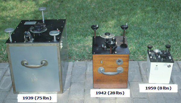
1939: Portable gravimeters
Introduction of portable, spring-type gravimeters. These gravimeters are called "relative gravimeters" because they measure the differences in gravity between points hence the gravity points are observed relative to each other only. The operating principle is simple: an object with a small mass is held by a spring. As gravity changes from point to point, the spring lengthens or shortens, and the observer compensates for this displacement mechanically (screw-lever systems). As these devices rely on springs to do their measurements, they need to be calibrated against known gravity points.
1939: Hudson Bay water level connected
In 1939 a connection to the Arctic Ocean was made when levelling conducted along the Hudson Bay Railway reached Churchill, Manitoba.
1940 – 1985: First-order field astronomy
One of the important but less-publicised activities in Geodetic Survey at this time was the provision of astronomic control by the Astronomy Section -usually first-order Laplace azimuths to control the triangulation and deflection determinations for geoidal studies. First-order field astronomy ended when the contribution of stations measuring deflection (of the plumb-line) to the refinement of the geoid was judged to be not worth the high cost: the funds could be better spent on acquiring gravity data.
1941 – 1950:Astronomic positioning for northern mapping
The GSD was charged with the task to supply astronomic second-order positional control at about 50 mile intervals for trimetrogon mapping (topographic mapping from one vertical and two oblique aerial photographs taken simultaneously). During the course of the next 10 years some 610 astronomic stations were to be established in this way. GSD used the T3 for second-order astronomy.
1947 – 1949: Application of Shoran for surveying in Canada
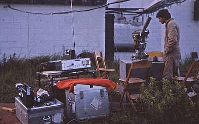
The application of Shoran (Short-Range Aid to Navigation) electronic length measurement to surveying and mapping was initiated in 1947. Development of the system involved four organizations; the Royal Canadian Air Force, National Research Council, the Meteorological Service and Geodetic Survey. Experimental work was conducted in the Ottawa area over several long lines of the first-order triangulation network.
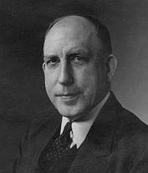
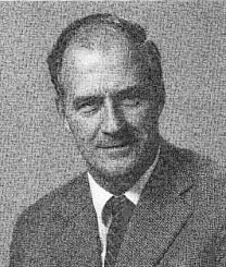
1947 – 1951: John Leslie Rannie
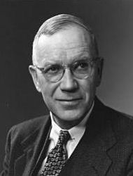
John Leslie Rannie, Dominion Geodesist and International Boundary Commissioner 1947-1951
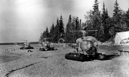
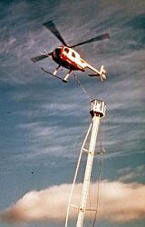
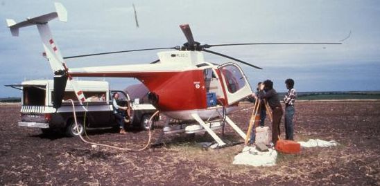
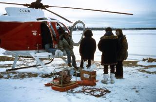
1948: First use of helicopters
The GSD first tried a helicopter for surveying operations in 1948. A Bell 47D was chartered for triangulation duties along the Alaska Highway in northern British Columbia (BC). The experiment met with limited success due to the unfavourable weather that prevailed that summer. However, the promise that helicopters would go on to make surveying faster and cheaper was realized.
1949: Department of Mines and Technical Surveys
In 1949 the newly created Department of Mines and Technical Surveys takes over responsibility for the GSD.
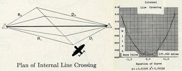
1949 – 1957: Shoran era
Shoran responded to control requirements for 1/250,000 topographic mapping in the remote areas of Canada. In Shoran triangulation, distance measurement was accomplished by a line crossing technique. An aircraft equipped with an airborne Radar (Radio Detection And Ranging) set is flown across the line joining two ground stations each with a Radar ground set. Dials on the airborne set give continuous readings in miles of the distance to each of the ground stations. The dials are photographed on 35 mm film at a preset interval of 3 seconds. At the point of crossing the sum of the slope distances is a minimum.
1950: First gravimeter calibration line
The first gravimeter calibration line was established in 1950 between Prescott, Ontario, and Maniwaki, Québec. In 1954 it was extended to Senneterre, Québec, and by 1955 to Washington, D.C.
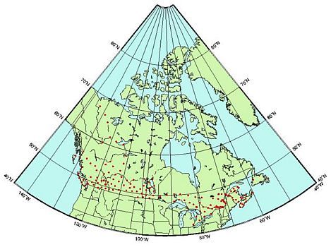
1951: Start Canadian Gravity Standardization Network (CGSN)
The first network of base stations was established in Ontario and Québec during 1951. The network expanded nationwide and formed eventually the CGSN comprising some 3,400 control stations.
1951 – 1957: J.E.R. Ross
J.E.R. Ross, Dominion Geodesist and International Boundary Commissioner 1951-1957
1955: International Great Lakes Datum (IGLD)
As a result of levelling work conducted since 1945, a connection was established between Pointe-au-Pere in Quebec and Kingston on Lake Ontario. The surveys and similar work in the United States formed the basis for a special datum called the IGLD to facilitate the regulation and development of various water works.
1956: Electronic Distance Measurement (EDM): Geodimeter 2
The Geodimeter (acronym for geodetic distance meter) was the invention of the Swedish Physicist Dr. Erik Bergstrand and was first introduced in 1953. The Geodimeter was a light-based EDM. By measuring the time required for a beam of light to travel to a bank of retroreflective prisms and back, it could accurately determine the distance between the two points.
1956: Last triangulation baseline measured by invar tape
In 1956, measurement of the last invar-taped baseline to be used in Canadian triangulation was carried out by G.A. Corcoran - a 9.8 km-long baseline near Keg River, Alberta.
1956 – 1991: Electronic Distance Measurement trilateration era
Conventional triangulation was greatly facilitated by the introduction of EDM for measuring baselines. By 1991 the superiority of Global Positioning System (GPS) had been established and Geodetic Survey abandoned EDM for extending survey control.
1957: Shoran Map
The Shoran trilateration network consisted of 119 stations at 400 km average spacing spread over some 6 1/2 million square kilometres or, roughly, 65% of Canada's landmass. Third-order and fourth-order standards of accuracy were achieved.
1957: EDM: Tellurometer MRA1
First used in Canada in 1957, the Tellurometer MRA1 was basically a time-measuring device. With one instrument, the "Master" unit, emitting a microwave that was received by a second instrument, the "Remote". A radio link was established between the 2 units and the operators could "line up" the instruments until a strong signal was obtained. Early instruments gave a readout in nanoseconds that had to be multiplied by the speed of radio waves to get the distance and corrected by the refractive index of air.
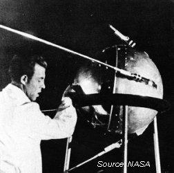
1957: Sputnik
An event of great scientific significance occurred in 1957, although few could guess the future impact on geodesy. Just days after the launch of Sputnik I, U.S. scientists were able to determine its orbit by measuring the Doppler shift of Sputniks radio signals. It was then suggested that if a satellites position were known and predictable, the Doppler shift could be used to accurately locate a receiver on Earth. Development of the U.S. TRANSIT system, also known as Navy Navigation Satellite System (NAVSAT), began in 1958, became operational in 1964 and was made available for civilian users in 1967.
1957: Computer
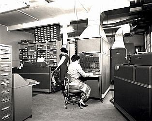
An International Business Machines Corporation (IBM) 650 electronic computer located at the University of Ottawa was used for the first time to process geodetic data.
1957 – 1967: J.E. Lilly
J.E. Lilly, Director and Dominion Geodesist 1957-1967
1959: Bilby tower
Triangulation was facilitated in 1959 when Geodetic Survey adopted the portable steel Bilby tower. It had been employed for many years by the U.S. Coast and Geodetic Survey. This greatly sped up tower construction in the more southerly areas of Canada where these towers could be transported by truck.
1959: Wild T4
The Wild T4 was introduced in the field and improved the efficiency of Laplace determinations. Prior to this, Laplace observations had been made with two different instruments. Longitude measurements were made using astronomical transits while azimuths were determined by observations on Polaris using theodolites such as the C.T.S. Tavistock (introduced in 1946) or the Kern DKM 3 (first used for this purpose in 1955). With the Wild T4 there was no further need for two instruments.
1959: Coast-to-coast triangulation network
A historical milestone was reached in triangulation with the completion of work in Manitoba, Canada finally had a continuous coast-to-coast triangulation network.
1960: Lacoste-Romberg gravimeter
Introduction of the Lacoste-Romberg gravimeter It was used not only on land but, with suitable modifications, also for ice surface and underwater measurements. It's still in use today.
1960: 615 Booth Street
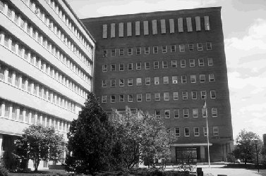
Opening of the Surveys and Mapping Branch Building in Ottawa
1961: Specifications for Control Surveys
The first comprehensive set of accuracy specifications for control surveys were issued by the Surveys and Mapping Branch.
1961: GROOM
Introduction of the first geodetic adjustment program in Canada called GROOM, designed by Klinkenberg and Wickens.
1961 – 1964: Northern triangulation
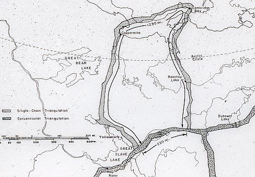
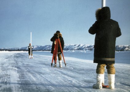
The most northerly first-order triangulation ever conducted in Canada, namely, from Yellowknife to Coppermine (now Kugluktuk) to Cambridge Bay to Fort Reliance, was surveyed between 1961 and 1964.
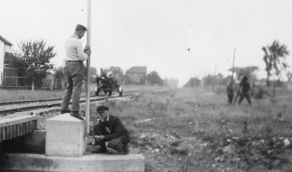
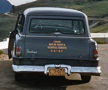
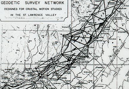
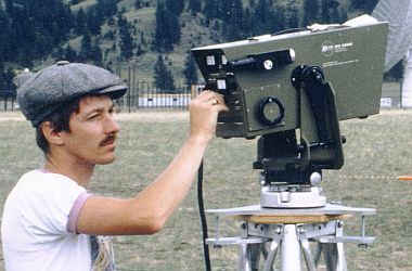
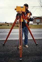
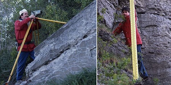
1964: Horizontal control for Crustal dynamics
Small geodetic networks were established to detect horizontal crustal motion, notably near Quebec City (photo), between opposite shores of the St. Lawrence River between Quebec City and Tadoussac, across the Strait of Georgia and across Robeson channel between northern Ellesmere Island and Greenland.
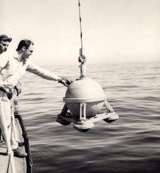
1964: Sea-surface gravimetry
A program of sea-surface gravity measurements was initiated by the Atlantic Geoscience Centre at Dartmouth, Nova Scotia. In this technique the gravimeter has to be mounted on a special gyro-stabilized platform designed to minimize the effects of the ship's motion on the gravity readings. During the next eighteen years some 295,000 sea-surface measurements would be made in this program alone, a major contribution to Canadian knowledge of gravity off the eastern and Arctic seaboards.
1964: Precise Levelling for Crustal dynamics
The discovery that vertical movement was taking place in the Lac St. Jean area of Quebec led to special level lines being established in the vicinity of three new dams along the Saskatchewan, Manicouagan and Peace River in Saskatchewan, Quebec and British Columbia. Measurements showed significant movements due to hydraulic loading. This work continued until about 1982. Then Geodetic Survey withdrew its support to the provincial hydro authorities concerned, because this type of work could now be done by private industry.
1964 – 1966: Satellite Triangulation
From 1964 to 1966, US Coast & Geodetic Survey (C&GS) established a network of survey stations covering North America by a method known as geometric satellite triangulation. Station positions were determined by photographing the passive satellites ECHO I and ECHO II against a background of stars using cameras originally designed for tracking ballistic trajectories (Wild BC-4 cameras). In the setup and operation of eight such stations in Canada, C&GS was assisted by personnel from the Geodetic and Topographical Surveys, and the Mapping and Charting Establishment (MCE). The stations were located at Whitehorse, Cambridge Bay, Lynn Lake, Timmins, Frobisher Bay (now Iqaluit), Goose Bay, St.Johns and Halifax.
1964 – 1970: Gravity on benchmarks
Between 1964 and 1970 some 3400 measurements were made and added to the National Gravity Data Base (NGDB).
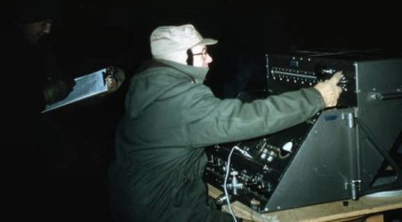
1965 – 1973: Aerodist
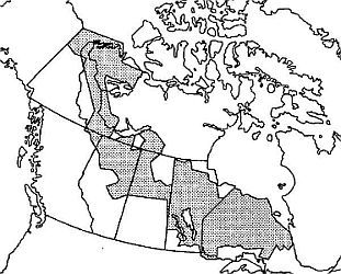
Aerodist was the airborne version of the Tellurometer and, like the Shoran system, it involved trilateration line crossing technique. Aerodist work by Geodetic Survey started in cooperation with Topographical Survey. It resulted in huge expanses of the northern parts of Canada being covered by primary horizontal control at roughly 100 km intervals. Over 8 years, some 201 primary stations were established over some 2.6 million square kilometres of Canada, (more than 25% of the total land area), many in inhospitable areas of muskeg, wooded swamps and the like where it would have been very difficult or virtually impossible to establish control by conventional methods.
1966: Department of Energy Mines and Resources (EMR)
The Department of Mines and Technical Surveys is reorganized as the Department of Energy Mines and Resources.
1967: Deep bench marks
To address the problem of bench mark stability on levelling operations, the deep bench mark designed by the National Research Council was introduced. It consisted in an inner galvanized steel rod pushed to refusal, protected by an outer galvanized steel pipe. The space between the two was filled with heavy oil. Freeze and thaw would affect only the outer pipe, leaving the inner rod intact. Installation was done by hydraulic drill rig mounted on a truck. During the summer of 1967, a total of 67 of these were installed at eight-mile intervals (13 km) between Toronto and Quebec City with an average depth of 40 feet (12 m), with the maximum depth being 180 feet (55 m) near Sorel.
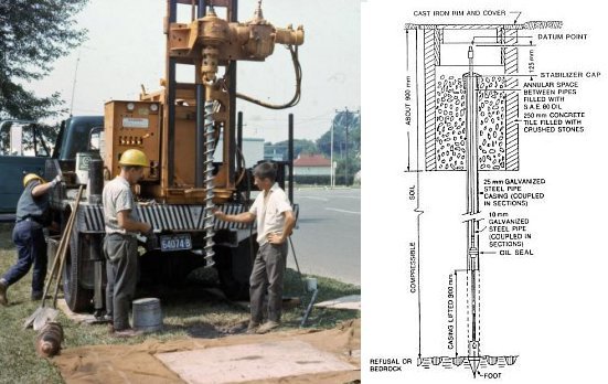
Right: Schematic of deep benchmark
1967: Invention of Very Long Baseline Interferometry (VLBI)
A group of Canadian radio astronomers and electrical engineers are the first to achieve interferometric fringes on a continental scale baseline. For this, they (along with a group of Americans) are awarded the Rumford Prize for the invention of VLBI .
1967 – 1974: L.A. Gale
L. A. Gale, Director and Dominion Geodesist 1967-1974
1968: Mapping Control
GSD is to provide all mapping control required for the National Topographic Series (NTS) mapping program. The field survey, computations and records staff of Topographical Survey were transferred to Geodetic Survey.
1968: First VLBI geodetic measurement
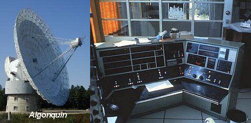
Harold Jones of GSD, Energy, Mines and Resources (EMR), using a baseline between the 26 m antenna at Prince Albert, Saskatchewan, and the 46 m antenna in Algonquin Park, performs the first ever geodetic interpretation of VLBI data. He recognizes the benefit of this type of measurement for aligning continental scale ellipsoids.
1968 – 1971: EDM: AGA Geodimeter 6
The Geodimeter Model 6 first appeared in 1964. It was smaller and lighter than its predecessors, using transistors instead of vacuum tubes. With a tungsten lamp light source the Model 6 had a range of about 7 km; with a mercury vapour lamp it had a range of about 20 km. Geodetic Survey used the Geodimeter 6 on municipal control surveys from 1968 to 1971.
1968 – 1972: IGLD re-levelling
Re-levelling of the lines of the International Great Lakes Datum commenced. To be completed in 1972 and provided further evidence of vertical crustal movement in the area of the Great Lakes.
1969: GALS
In 1969 a computer program named GALS (Geographic Adjustment by Least Squares) designed by McLellan, Peterson and Katinas was put into production, supplanting GROOM.
1969 – 1972: Gyro-theodolite experiments
Under the leadership of L. F. Gregerson, GSD carried out tests to radically improve the accuracy of the gyro-theodolite. Modifications to the mathematical modeling and the development of an electronic reading device reduced the standard error of the gyro-determined azimuth to less than three seconds of arc for mid-latitudes (less than six seconds at higher latitudes up to 80 degrees). These developments resulted in the use of gyroscopic azimuth determinations for lower order surveys by Geodetic Survey, the military and some provincial agencies.
1970: First trilateration projects
In 1970, the first trilateration projects were initiated. As EDM instruments with ever-increasing precision became available, the emphasis switched from triangulation to trilateration.
1970 – 1972: Worldwide Geometric Satellite Triangulation Program
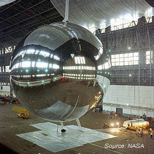
With the launch of PAGEOS (the Passive Geodetic Satellite) in 1966, the US National Geodetic Survey (formerly the US Coast & Geodetic Survey) set aside its North American Satellite Triangulation Program (see 1964-66) in favour of the Worldwide Geometric Satellite Triangulation Program. PAGEOS was placed in a higher orbit than the ECHO satellites, allowing for the determination of longer baselines. During the period 1970 to 1972, four of the eight Canadian stations established in the 1964-1966 North American densification programs were re-occupied with the assistance of personnel from Geodetic Survey and MCE.
1971: Coast-to-coast re-levelling
Completed in 1971, the coast-to-coast levelling along main highways indicated an apparent difference of about 2 metres between mean sea levels on the Pacific and Atlantic coasts. This was a puzzling result as the original trans-continental line completed in 1916 had indicated a difference of only 60 cm that agreed closely with steric levelling values.
1971: Automatic level
Launched in 1967 the Zeiss Ni-1 was the first automatic precise level used by Geodetic Survey. The Ni-1 was an improvement on the Ni-2 (the first automatic level, launched in 1950). The Ni-1's telescope power increased to 50x and the parallel-plate micrometer was integrated into the instrument.
1971: International Gravity Standardization Net (IGSN) adopted
Official adoption by the International Union of Geodesy and Geophysics (IUGG) of the International Gravity Standardization Net. Twenty stations of the CGSN would be tied securely to the IGSN, making Canadian gravity values much more useful for international studies in geodesy and geophysics.
1971 – 1973: National Geodetic Baseline (NGBL) established
The 2.3 km-long National Geodetic Baseline (NGBL) was established by three separate precise invar tapings. This was the last time invar tapes were used to measure geodetic baselines. The NGBL would become the reference baseline for other future calibration baselines across Canada.
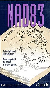
1972: North American Datum of 1983 (NAD83)
The requirement for a comprehensive readjustment of all Canadian primary horizontal networks was recognized. Geodetic Survey readily agreed to participate with US counterparts in a readjustment of all North American networks on a redefined datum. The huge project later to be known as 1983 North American Datum (NAD83) was born.
1973: GEODOP
Doppler software packages were developed including such programs as PREDOP, GEODOP and GDLSAT. These would see use throughout the world.
1973: 95% Confidence region
New control survey specifications established the 95% confidence region as the basic criterion for assessing the accuracy of horizontal control. Greeted with some dismay initially by many in the Canadian surveying community, these specifications became popular later and were widely adopted outside the Surveys & Mapping Branch.
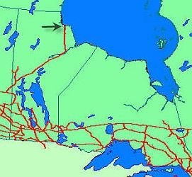
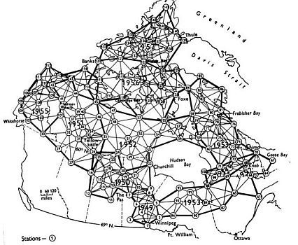
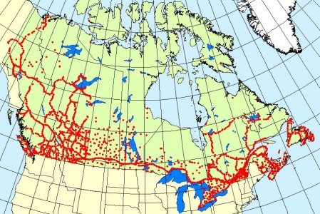
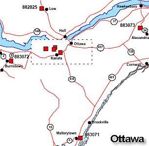
1973: Aerodist coverage map
Map of Aerodist coverage in Canada
1973: Lambert Tower
First introduced in 1973 and named after its inventor, International Boundary Commissioner A.F. Lambert, the Lambert tower was designed to fill a need within the boundary commission for a lightweight, easily erected instrument observing tower. Assembly of the 18.2 metre (60 foot) aluminum tower is completed on the ground. It is then raised into position using an A-frame and secured with guy wires. It can be transported as a unit by helicopter and held erect while it is guyed down. Originally designed to satisfy second-order control specifications, the tower was modified to achieve first-order results following testing by Geodetic Survey. GSD then used the Lambert Tower on a number of horizontal control projects during the 1975, 1976 and 1977 field seasons.
1973 – 1985: Doppler Era
Doppler was adopted for first-order positioning purposes. Cost per station was about 25 percent that of Aerodist, and some 50 percent that of conventional triangulation. Fifty satellite passes had to be observed simultaneously at two (or more) stations. Geodetic Survey established a fundamental first-order national framework of 196 Doppler stations spaced about 300-500 km apart. Up to the end of the 1981, 800 Doppler stations were established. In 1985, the last major use of Doppler was to establish 58 stations in British Columbia and the Northwest Territories for the purpose of first-order densification. The best Doppler accuracies were about 50 cm for position and 70 cm for spheroidal heighting.
1974: Ground Elevation Meter (GEM)
The Ground Elevation Meter (GEM), a unique inertial device, was first used to determine elevations for mapping control. This instrument reliably produced many thousands of kilometres of inexpensive vertical control suitable for 1/50,000 mapping. Sensors continually monitored changes in slope, the velocity of the vehicle, and the distance travelled. Incremental differences of elevation obtained were integrated by an on-board computer to produce total elevation differences between stations.
1974: Electronic Distance Measurements (EDM): Kern ME3000 Mekometer
The first high-precision EDM instrument, the Mekometer, was built in 1961 at the National Physical Laboratory in the U.K. and introduced commercially in 1973 as the Kern Mekometer ME3000. Its carrier signal was produced by a Xenon flash tube. Meant for shorter distances, it attained accuracies of ?????. GSD used it for measuring dam deformation and monitoring the stability of structures.
1974: Field Manual for First-Order Horizontal Control Surveys
Technological advances in instrumentation, survey methods and computing facilities necessitated the issue of a new instructional manual (Field Manual for First-Order Horizontal Control Surveys) to replace outdated previous manuals.
1974 – 1986: L.J. O'Brien
L.J. O'Brien, Director and Dominion Geodesist 1974-1986
1974 – 2004: EDM Baseline program
Geodetic Survey and provincial surveying organizations cooperated in the establishment of baselines for the calibration of measuring equipment used by surveyors and engineers. Geodetic Survey measured all baselines with a Kern Mekometer ME3000 or its successor the Geomensor CR204 for 2 consecutive years. Results were published. The last EDM reobservation was done in 2004. EDM baselines are no longer maintained by GSD.
1975: Trigonometric Level Crossing of the Strait of Belle Isle
In the mid-1970s the construction of a tunnel under the Strait of Belle Isle for the transmission of electrical power from Churchill Falls to the island of Newfoundland was proposed. It would be constructed from both ends of an 18.3 km-long crossing and meet in the middle, so it was imperative that the elevation difference between the ends be known within 15 cm to provide adequate vertical control. Geodetic Survey was enlisted to make the necessary vertical control transfer. Special trigonometric techniques had to be employed. A network in the form of a braced quadrilateral, including four over-water lines, was created. Simultaneous reciprocal vertical angles were measured using Wild T4 theodolites, which were mounted on towers to avoid unsatisfactory meteorological conditions. Analysis of the results confirmed that the surveys objective was reached. However, the tunnel was never constructed.
1975: Geoid modeling
A Physical Geodesy Section was formed and Dr. G. Lachapelle developed software that used a combined least squares collocation and integral formulae method to evaluate geoid undulations and deflections from a combination of satellite dynamic, surface gravity and astrogeodetic data.
1975 – 1991: Inertial Surveying System (ISS) era
A Litton Autosurveyor inertial navigation system adapted to surveying was purchased, one of the most important and most expensive capital purchases in GSD history. During its first 6 full seasons in operation, over 5,800 control stations were established, most of them in the prairie provinces. New ISS units (Litton LASS II) were purchased in 1984 to replace the well-worn originals. ISS also provided mapping control for numerous federal projects, multipurpose control along the main highways in the Yukon and Northwest Territories, and control for gravimetry. One unusual task featured three-dimensional control on the Columbia Ice field to aid researchers in determining the rates of ice creep and melt.
1976: EDM: K&E Ranger
The Keuffel & Esser Company developed the Ranger series of laser-based EDMs. It was introduced in 1970, cost $8,000 (USD), and had a self-contained digital computer that made it completely automatic and extremely fast. It had a range of from 1 meter to 6 km with an accuracy of ±5 mm +2 ppm. It weighed 32 lbs (14.5 kg), and used a 12-volt power supply. The Ranger IV, introduced in 1976, had a greater range (from 1 meter to 13 km) and was designed with plug-in modular construction to permit quick parts replacement.
1976: Western Canada geodynamics
Geodetic Survey and the Earth Physics Branch initiated close cooperation in monitoring larger-scale earth crustal movements. Most work in the programme (special order levelling) was originally concentrated on Vancouver Island.
1976 – 1986: ISS in the prairies.
Through joint federal-provincial projects GSD established 10,000 stations using ISS in Manitoba, Saskatchewan and Alberta between 1976 and 1986.
1976 – 1995: Levelling contracted out
In line with the federal government's new contracting-out policy, Geodetic Survey Division contracted-out precise levelling from 1976 to 1995. In-house staff retained the special-order levelling for monitoring earth movements.
1977: Doppler replaces Conventional
The decision was made not to propagate primary horizontal control by conventional methods in the future as Doppler positioning methods were superior over long distances.
1977 – 1990: North American Vertical Datum of 1988 (NAVD88)
The start (in cooperation with United States National Geodetic Survey) of the proposed readjustment of North American Geodetic vertical networks on a redefined datum. Initial work consisted of studies of the technical problems associated with the comprehensive project, the letting of a large university contract for research into some of these problems, and the automation of first-order levelling data. This project is continuing under the title of 1988 North American Vertical Datum. The United States adopted NAVD88 but Canada did not.
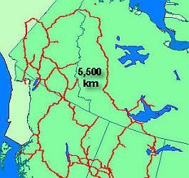
1978: Largest levelling loop
The first-order levelling line down the shores of the Mackenzie River, from Great Slave Lake to Arctic Red River was the first Canadian precise levelling operation to ever extend north into the Arctic Circle. In 1978, with the construction of the Dempster Highway, a connection to Arctic Red River from Dawson, Yukon, completed the largest precise levelling loop in geodetic history with a periphery of some 5,500 kilometres.
1978: Canadian benchmarks in Alaska
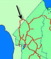
Some 180 km of levelling was done from Tetlin Junction in Alaska through to the Alaska-Yukon boundary, following the Taylor Highway, completing a 1300 km loop. This project featured an amusing incident. The first 150 km of levelling from Tetlin Junction would pass through Alaska, and permission was obtained in advance from the United States National Grid Solutions (USNGS) for this work to be done. USNGS wanted its own benchmarks used and agreed to supply them to the Canadian party. When it became clear that their arrival would be long delayed, the party chief, M. Berrigan, was compelled to use hastily modified standard Canadian benchmarks. However only minor modifications could be made with the equipment on hand. Consequently this unique United States line of levels today sports benchmarks with caps carrying inscriptions in Canada's two official languages.
1978: Specifications for Control Surveys
The Surveys and Mapping Branch issues a revised edition of the 1973 publication Specifications and Recommendations for Control Surveys and Survey Markers.
1979: ISS Survivors
The ISS lived a charmed life, surviving many serious helicopter crashes and a number of minor mishaps. The worst of these crashes occurred in October 1979 near Jenpeg, Manitoba. On returning from a mission the helicopter snapped a tail rotor coupling and plunged into the Nelson River. The field officer, M. Strutt, and pilot J. Ryan were able to swim to an island nearby, and waited for four hours in below-freezing temperatures before being rescued. But the best was yet to come. ISS units survived a serious crash in Alberta in 1983, crashes in Saskatchewan and the Yukon in 1984, and, in 1985, two more in Québec. Miraculously no personnel were killed or seriously injured in these accidents, but many helicopters had to be replaced.
1979: The T-stick
GSD began using "T-sticks" to measure the temperature gradient all along the levelling route. One field person was dedicated to the T-stick. It had 3 temperature probes placed at heights of .5 m, 1 m and 1.5 m and temperatures were taken at every setup. The "T-stick" was used on all levelling projects from 1979.
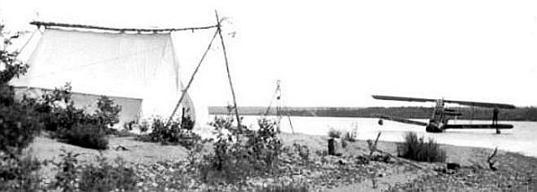
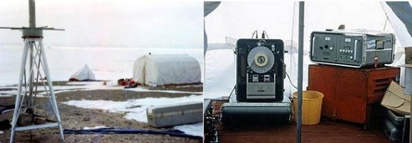
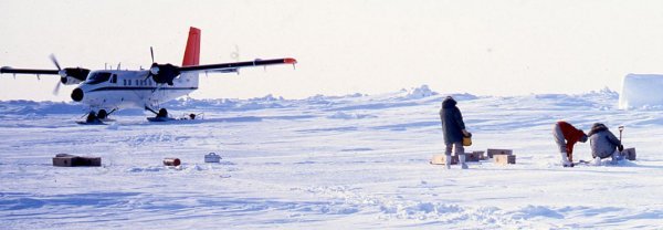
1979: Lomonosov Ridge Expedition (LOREX) and Canadian Expedition to Study the Alpha Ridge (CESAR) projects
In 1979 the Earth Physics Branch led and coordinated the polar expedition LOREX . This was followed in 1983 by its leadership and coordination of the Canadian Expedition to Study the Alpha Ridge (CESAR). These expeditions, both on sea ice, were sponsored by the federal Department of Energy, Mines and Resources, and were supported by the Polar Continental Shelf Program (PCSP) and the Canadian Armed Forces. Conducted by several Canadian government agencies and by Canadian and United States universities, the scientific programs for both expeditions were similar and mainly devoted to geophysical and marine geological investigations. GSD personnel determined plumb line deflections by taking some 50 daytime star observations on a daily basis.
1979: Changes in Canada Lands Surveys Act
In 1979, the Canada Lands Surveys (CLS) Act and examination regulations were broadened to include the commissioning of persons practicing in the various disciplines in the major fields of survey including hydrography, photogrammetry and geodesy. Until then, the awarding of commissions had been limited to cadastral or land surveys. Under the grandfathering provision of the new regulations (Section 12), a number of GSD employees attained their CLS commissions.
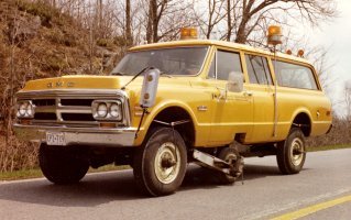
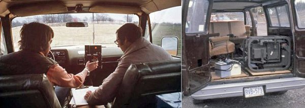
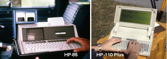
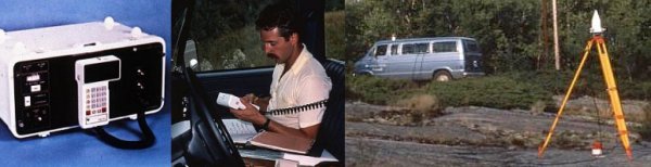
1981: Automated data recording
The use of portable computers for automated data recording greatly sped up the levelling process. The instrument man and T-stick man both called out their readings via walkie-talkies to the recorder in a van. These early models were pre-DOS.
1981: Magnetic error discovered
Investigations in Europe confirmed that precise levelling done with most makes of automatic levels suffered from systematic errors caused by the Earth's magnetic field acting on the compensators. Only lines running north-south or close to it were affected, and the size of the error varied with the make of level. The average error (about 1 mm per km) was tantalizing. It was very small, but just large enough to warrant, for first-order levelling, attention and expensive correction.. Over the next ten years some 20 000 km of levelling would be redone, and an empirically determined correction factor would be applied to other lines to correct matters.
1982: Ni002 level
A major innovation in precise levels was the Zeiss Ni-002. The instrument's well proven accuracy of +/- 0.2 mm per km was achieved by its design concept which included a unique reversing mirror compensator. A pendulum mirror was suspended at half the focal distance and measurements were made in the initial and the reversed position. The mean of the two readings provided what is called a "quasi-absolute horizon". With all its knobs situated on both sides of the level and its rotating eye-piece the observer could take forward and backward sights without having to move around the instrument. Although not designed for motorized levelling the Ni-002 was ideally suited.
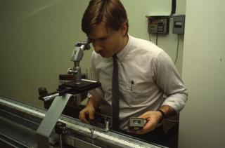
1983: GPS testing: Macrometer V-1000
Field tests of the Macrometer V-1000 prototype, the first GPS system suitable for geodetic work, are conducted by personnel from the Earth Physics Branch, University of New Brunswick and GSD. While the results were promising, the consensus of opinion was that the system would require considerable modification to become a viable, field-deployable instrument.
1983: GPS testing: Texas Instrument-4100 (TI-4100)
Tests of first-generation Texas Instrument (TI-4100) GPS receivers were being undertaken in Canada by 1983. These tests produced excellent results despite the fact that only a few of the planned twenty-one GPS satellites were then in orbit. Software development was proceeding in parallel with this testing in government, universities, and private industry.
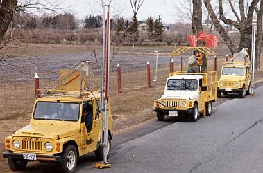
1983 – 1987: Motorized Levelling
Experience in Sweden indicated that motorized precise levelling could be very productive. In 1981 and 1982 a prototype system was built and tested, featuring three four-wheel drive vehicles. Production work was started in 1983 with the system equipped with an automated data recording system. After early development problems had been solved, the unit's greater productivity in comparison with levelling on foot (about 40 percent) soon became apparent. Despite increased productivity, the original motorized levelling system was retired in 1987 following unsuccessful attempts at privatization and commercialization.
1983 – 1988: Parliament Hill Stability Measurements
In 1981, it was first noticed that the ground was sinking between the Parliament Buildings and the edge of the cliff bordering the Ottawa River. The Department of Public Works enlisted the assistance of GSD in 1983 to establish a network of control stations from which measurements could be taken to selected points on the cliff face. To ascertain if any movement was taking place, repeated sets of measurements were performed twice a year and the results were compared. The KERN Mekometer ME3000 was used for distance measurement and the Wild NA2 for precise levelling (which proved to be laborious due to the extreme slope of the terrain). After four years, no significant movement of the monitoring points was detected.
1984: VLBI measures continental drift
Observations are taken at the 46 m antenna at Algonquin Park and mobile antenna sites at Penticton, Yellowknife and Whitehorse as part of National Aeronautics and Space Administration's (NASAs) Crustal Dynamics Project (CDP). These observations contribute to CDP s first ever real-time measurements of continental drift.
1984 – 1987: Hobson's Choice
A research station was established on an ice island that had broken off from the Ward Hunt Ice Shelf. Dubbed "Hobson's Choice" (a humorous reference to George Hobson, then director of PCSP), measuring some 4 by 6 km and about 45 m thick, it was then located near the entrance to Nansen Sound, floating among sea ice some 2 m thick. Over the next few years the ice island became a floating platform for geophysical and marine geological research. It also served as a base for bathymetric and gravity surveys over the continental shelf and margin. GSD personnel employed Doppler and GPS methods to ascertain its drifting pattern. Later, in 1987, the ice island served as a base for a gravity operation that resulted in the establishment of 1900 stations on Arctic sea ice, completing the gravity coverage of the polar shelf from the Beaufort Sea to the Lincoln Sea, the culmination of twenty-five years of effort.
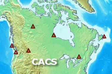
1985 – 1993: Canadian Active Control System (CACS) development
The concept of a Canadian Active Control System (CACS) was advanced during 1985, principally by R. Steeves. The equipment for a prototype station was assembled and functioning well by 1987. The CACS was implemented in stages in close cooperation with the provinces and private industry. By the end of 1993 seven prototype automated tracking stations were operating. Called Active Control Points (ACP), they were located at St John's, Algonquin Park, Churchill, Yellowknife, Penticton, Victoria, and Holberg, British Columbia.
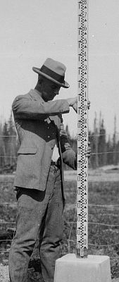
1985 – 2002: Rod Calibration Bench
GSD developed its own rod calibration system when the National Research Council (NRC) stopped providing a calibration service. A laser interferometer measured to micron accuracy the movement of the levelling rod along a track. In 1985 calibration was done manually at a sampling of graduations. By 1996 the system became fully automated with the addition of a motor-driven photoelectrical microscope measuring every graduation. Until 2002 GSD calibrated its own rods as well as those of many Canadian and American organizations. By 2003 very little precise levelling was being done and the bench required hardware and software upgrades. In addition a flood forced the displacement of the laser so we stopped using the system. Rods can still be calibrated at Laval University.
1985 – 2007: JILA-2 gravimeter
The JILA-2 was the first absolute gravimeter acquired by the Department of Energy, Mines and Resources. The Earth Physics Branch (EPB) purchased this device from the University of Colorado in Boulder. This instrument was used throughout Canada and abroad from 1985 to 2007 by the EPB, the GSC and finally, from 1995 onward, by the GSD.
1986: Gravimetric geoid
A Canadian gravimetric geoid was produced at the University of New Brunswick by P. Vanicek.
1986: Gravity program transfer
The Gravity Program was transferred from the EPB of EMR to the Geophysics Division of the Geological Survey.
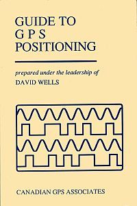
1986: Canadian Guide to GPS Positioning
Canadian expertise in GPS became more evident with the publication of The Guide to GPS Positioning, a 600-page book Co-authored by eleven Canadian experts under the leadership of David Wells of the University of New Brunswick.
1986 – 2006: GPS on Benchmarks
In 1986, GSD began a campaign to establish three-dimensional, GPS -derived coordinates on benchmarks at 30 km intervals in the first-order levelling network. The main purpose of this program was to better understand and redefine the geoid model in Canada. Operations were carried out both by in-house personnel and by contracting out.
1987 – 1989: George Babbage
George Babbage, Director and Dominion Geodesist 1987-1989
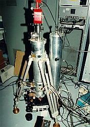
1987 – 2009: Canadian Absolute Gravity Station (CAGS)
The Canadian Absolute Gravity Station (CAGS) is the principal gravity laboratory which houses all absolute gravimeters of the Division, starting with the JILA-2 absolute gravimeter in 1987. This laboratory provides a stable and controlled environment for the gravimeters. At present, it is the starting point for JILA-2, A10-003 and FG5-236. Since 1989, a superconducting gravimeter (SG), one of the world's most sensitive gravimeter, has been installed on the same pier as the absolute gravimeters. It provides precise measurements of earth tides and the nearly diurnal free wobble of the earth. The co-location of the two types of instrument provides an opportunity to examine the drift of the superconducting gravimeter and to search for spurious signals in either instrumentation. A complete weather station and two wells provide for continuous environmental monitoring.
1988: Arctic Ocean Connected
A winter precise levelling project of note occurred in the Northwest Territories, above the Arctic Circle. The requirement was to run a line of levels for about 220 km from Inuvik to a tide gauge at Tuktoyaktuk, following a sinuous winter "ice" road to make the first connection of the national levelling network to a mean sea level reference at the Arctic Ocean. This would provide a vital tidal gauge anchor for many thousands of kilometres of levelling established in western and north-western Canada.
1988: Global Orbit Tracking Experiment (GOTEX) Campaign
The GOTEX Campaign is an international project to improve knowledge of the orbits of GPS satellites by means of a series of coordinated, systematic, high-accuracy observations at selected stations around the world. Canada's contribution of twenty-nine stations, spread across the country, helped significantly to improve the utility of the system.
1988: CASA UNO Campaign
CASA UNO, an acronym for the first (uno) in a series of cooperative GPS campaigns to monitor tectonic motion in Central and South America. The project was led by NASAs Jet Propulsion Laboratory and involved 28 participating agencies operating at more than 50 sites around the world. The object was to establish benchmark positions for each of the field sites that could be compared with subsequent measurements. GSD supplied two experienced GPS operators for the campaign: J. Davidson occupied a station in New Zealand and R. Morris one on Cocos Island, some 500 km off the western coast of Costa Rica.
1988 – 1997: GPS Validation Networks
A cooperative program with provincial agencies to establish GPS validation networks (also referred to as basenets), similar to the EDM baseline program, was started in 1988. Generally a validation network consisted of six or more stations forming a local network incorporating previously established baselines, to test the reliability and accuracy of GPS equipment (including software) intended for use in production work. By the end of 1997 a total of fifteen basenets had been established across the country.
1989: Handheld GPS
The first commercial handheld GPS receiver was the Magellan NAV-1000. At a cost of just under $3000 it had a single channel which tracked sequentially the L1 CA-code for the best 4 satellites. Originally designed for maritime use it could float. It operated on 6 AA alkaline batteries and could store 50 waypoints.
1989 – 1995: David Boal
David Boal, Director and Dominion Geodesist 1989-1995
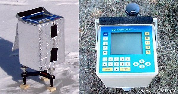
1990: SCINTREX gravimeter
The SCINTREX relative gravimeter has integrated GPS capability and measures spring movement by electrostatic compensation.
1990: ARO starts regular VLBI observations
GSD recognizes the importance of global reference frames to Canada. The 46 m antenna at Algonquin Park begins regular observations as part of global geodetic VLBI observing programs. These observations benefit the definition of the ITRF, the International Celestial Reference Frame (ICRF) and regular measurements of Earth Orientation Parameters (EOP).
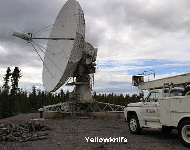
1991: VLBI - MV1 antenna
GSD acquires NGSs 9-m MV1 antenna on indefinite loan to establish a permanent geodetic VLBI site at Yellowknife.
1991 – 1993: GPS replaces ISS
There was an intensive three-year gravity data gathering campaign from 1991 to1993. ISS was used to provide positioning control in 1991 but could no longer compete with GPS, which was used for control in 1992 and 1993.

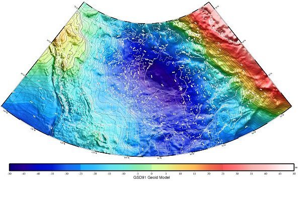
1992: GSD91
A national geoid prediction package, called GSD91 was released by the Geodetic Survey for general use. The accuracy is about 5 to I0 cm in elevation for most regions of Canada, deteriorating to about 25 cm in mountainous areas.
1992: GPS on Mount Logan
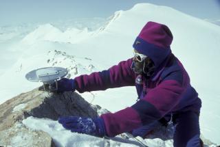
GPS was used to confirm the height of Canada's highest mountain, Mount Logan. GPS receivers were backpacked to the summit by a fifteen-person expedition headed by M. Schmidt of the Geological Survey of Canada. GSD's J.C. Lavergne was also of the expedition which was a partnership between the Royal Geographical Society of Canada, Geological Survey, Geodetic Survey, and the National Parks Service. Despite numerous hardships the expedition was able to make measurements on June 6th and 8th. The result was a new official height of 5959 m (19,550 ft.) above mean sea level. The previous official value was 5951 m.
1992 – 1993: Airborne GPS for Multi-detector Electro-optical Imaging Scanner (MEIS) System
The Geodetic Survey Division, Canada Center for Remote Sensing (CCRS), private industry and the Regional Municipality of Waterloo, Ontario all collaborated in a joint project to position airborne remotely sensed imagery using a GPS receiver on board an aircraft. The remote sensing data was collected with the MEIS.
1993: International GNSS Service (IGS)

The Geodetic Survey Division becomes a contributing agency to the International GNSS Service. IGS is a voluntary federation of more than 200 worldwide agencies that pool resources and permanent GPS & GLONASS station data to generate precise GPS & GLONASS products. The IGS provides the highest quality data and products as the standard for Global Navigation Satellite Systems (GNSS) in support of Earth science research, multidisciplinary applications, and education. Orbits and terrestrial reference frame products of the IGS, a Service of the International Association of Geodesy, are recognized as de-facto standards offering the highest-precision by the international civilian GPS community.
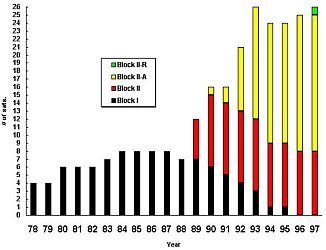
1993: GPS full constellation
GPS finally has its full constellation of 21 satellites.
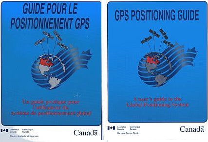
1993: GPS Positioning Guide
In 1993, GSD issued a GPS Positioning Guide to inform users about the practical application of GPS technology to meet their diverse positioning requirements.
1993 – 1994: Satellite Laser Ranging (SLR)
In 1993, as part of an international cooperative program to monitor the effects of global environmental change in northern circumpolar regions, GSD established two sites to support Satellite Laser Ranging (SLR) operations: one at the Algonquin Radio Observatory (ARO) and one near the La Grande-1 hydroelectric dam east of James Bay. A transportable laser ranging system, or TLRS, belonging to NASA conducted observations at ARO in the summer of 1993, and returned to Canada the following summer to occupy the LG-1 site.
1994 – 1999: Canadian Base Network (CBN) installation
The Canadian Base Network (CBN) comprises about 160 nationally distributed sites with monumented geodetic pillars on which a GPS antenna or a theodolite can be installed. These pillars were positioned three-dimensionally with GPS to centimetre-level accuracy respective to the Canadian 3-D positioning standard North American Datum of 1983 (NAD83) (Canadian Spatial Reference System (CSRS)). CBN pillars are reference markers used by surveyors to access NAD83 CSRS coordinates that also serve to monitor the deformation of the Earth's crust across Canada. While recognized as the federal layer of primary 3-D geodetic control, the CBN network was built in cooperation with provincial survey agencies and its stations are used as anchor points for their respective High-Precision Networks densification.
1995: Natural Resources Canada (NRCan)
In 1993 the Department of Energy, Mines and Resources (EMR) changes its name to NRCan, though the Department of Natural Resources Act, which merges EMR with Forestry Canada, does not officially come into force until January 12, 1995.
1995: National Gravity Program moves to Geodetic Survey Division (GSD)
The Gravity group from the Geophysics Division of the GSC is transferred to the GSD as part of the Departments reorganization.
1995 – 1996: Mark Corey
Mark Corey, A/Director 1995-1996
1995 – 2007: GPS Precise Point Positioning (GPSPace)
GPS precise point positioning (PPP) is adopted as a methodology for high-precision positioning using precise GPS orbit and clock products. The use of GPS PPP with high-rate satellite clocks was an effective way of mitigating the impact of Selective Availability in the mid-90's and improve user positioning precision in post-processing from 100 to 1 metre. The upgrade to include the processing of carrier phase measurements in the late 90's has now improved performance to the centimetre precision level, now accessible to end-users over internet using GSD's on-line Canadian Spatial Reference System (CSRS) - PPP Service.
1996: North American Datum 1983 (CSRS)
NAD83 (CSRS). This is an updated high-accuracy, three-dimensional realization of the NAD83 reference system.
1996 – 1997: Cyril Penton
Cyril Penton, A/Director 1996-1997
1997: Canadian VLBI S2 system completed
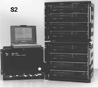
The Geodetic Survey Division, in collaboration with the Space Geodynamics Laboratory (SGL) of CRESTECH, the National Research Council of Canada (NRC) and the Canadian Space Agency (CSA), completes a state-of-the-art end-to-end Canadian VLBI system. The system is intended for both geodetic and space-based radio astronomy applications. The system is called the S2 system. In the same year, GSD commissions the 3.6-m Canadian Transportable VLBI Antenna, for eventual use in Penticton, British Columbia, Shirley's Bay, Ontario, and St. Johns, Newfoundland.
1997 – 1999: JILA-4 gravimeter
The second absolute gravimeter, model JILA, was acquired from National Oceanic and Atmospheric Administration (NOAA) to complement the first instrument, JILA-2.
1997 – 2001: Denis Hains
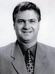
Denis Hains, Director 1997-2001
1997 – 2009: GPS-C
GPS -C, short for GPS Correction, is a source of real-time wide-area GPS corrections for Canada and most of North-America. Within seconds, real-time data is acquired from tens of permanent GPS tracking stations spread across North-America, processed centrally in Ottawa, uplinked to a communication satellite and broadcast over-the-air to users. The Canada-Wide Differential GPS Service (CDGPS), the Canada-Wide Differential GPS Service, a collaboration of federal-provincial geomatics agencies, has supported the GPS -C broadcast and user community since it became operational in 2003. When used with a CDGPS-enabled receiver, GPS -C improves real-time positioning accuracy to about 1-2 meters, from its 10 metres stand-alone accuracy.

1998 – 2006: International VLBI Service (IVS)
Creation of the International VLBI Service (IVS) for Geodesy and Astrometry, an international collaboration of organizations which operate or support VLBI components. Geodetic Survey joined the IVS in 1999 and was a participating member until 2006.
2000: A10 absolute gravimeter
A new type of portable absolute gravimeter was acquired from Micro-g Solutions. Early technical problems have delayed its full deployment.
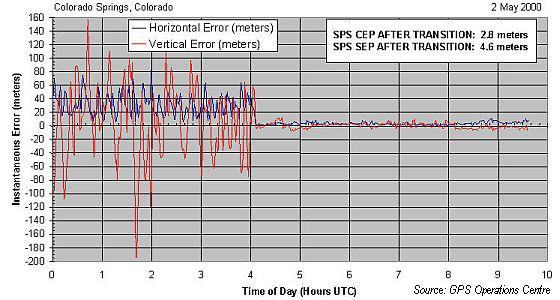
2000: Selective Availability (SA) discontinued
May 1, 2000 at the direction of the United States President Bill Clinton, SA, an intentional degradation of public GPS signals implemented for national security reasons, was discontinued.
2001 – 2004: Robert Laframboise
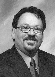
Robert Laframboise, Director 2001-2004
2003: IVS network established
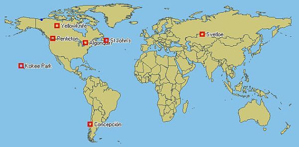
A network of stations using the Canadian S2 System is established as part of the IVS. Regular global observations are taken including Canadian stations at Algonquin Park, Yellowknife, Penticton, and St. Johns, and international stations at Concepcion, Chile, Kokee Park, Hawaii, and Svetloe, Russia. These observations significantly enhance Canada’s contribution to the International Terrestrial Reference Frame (ITRF) and through its period of operation contribute nearly 10% of VLBI EOP determinations.
2003 – 2009: Canada-Wide Differential GPS Service (CDGPS)
CDGPS is a real-time wide area Differential Global Positioning Service (DGPS) that provides unmatched accuracy and coverage for positioning applications throughout Canada, with collateral equivalent benefits extending across North America. As a wide-area satellite-based service the broadcast CDGPS corrections can be accessed anywhere within the mobile satellite (MSAT) coverage footprint, using CDGPS-enabledGPSreceivers. The correction data, optimized for North America, provides metre-level accuracy with single frequency GPS receivers and sub-metre accuracy with dual frequency technology. The service is being offered as a free utility. CDGPS has been developed in a collaborative partnership between the provincial, territorial and federal governments of Canada and has been approved as a national DGPS standard for surveying and mapping applications.
2003 – 2009: On-line Canadian Spatial Reference System (CSRS) - Precise Point Positioning (PPP)

NRCan's PPP (Precise Point Positioning) is an online GPS post-processing service that improves the accuracy of user-submitted GPS datasets. Taking advantage of internet connectivity and continuous access to accurate global GPS orbit products, the PPP web application determines user coordinates with centimetre accuracy (latitude, longitude, ellipsoid height) in either national (NAD83 (CSRS)) or international (ITRF) reference systems. Datasets from single or dual-frequency receivers collected either in static (stationary antenna)) or kinematic (moving antenna) mode can be accommodated. PPP solution reports are emailed to users within seconds of submissions once a 90 minute delay for hourly orbits and clocks computation has elapsed. PPP also integrates the HTv2.0 height transformation module, producing orthometric (mean-sea-level) heights compatible with CGVD28 elevations.
2004 – 2005: Jean Robert Duval
Jean Robert Duval, A/Director 2004-2005
2005: Peak VLBI activity
The antenna at Algonquin Park reaches its peak activity, participating in 105 international observing sessions. It is widely recognized as one of the premier geodetic VLBI sites in the world.
2005 – 2007: Stuart Salter
Stuart Salter; A/Director 2005-2007
2006: NRCan ceases VLBI operations in Canada
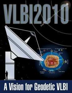
The decision is made to cease VLBI operations and end GSD's contribution of data from Canadian observatories to the International VLBI service (IVS). GSD continues to provide expertise to influence the international community in the development of next-generation, low-cost VLBI observing systems. This initiative, known as VLBI 2010, could lead to high-performance modern geodetic VLBI systems becoming available as soon as 2012.
2007 – 2009: FG5 absolute gravimeter
The second portable absolute gravimeter, model FG5, acquired by the Department. The first FG5 was purchased by the Geological Survey of Canada (GSC) in 1993. The stated precision of these gravimeters is 2 parts per billion of the total Earth’s gravity field.
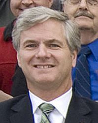
2007 – 2009: Denis Hains
Denis Hains, Director 2007-today
2008 – 2009: United Nations Convention of the Law of the Sea (UNCLOS) Project
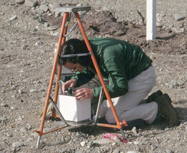
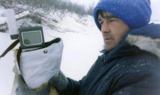
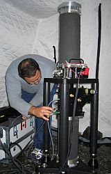
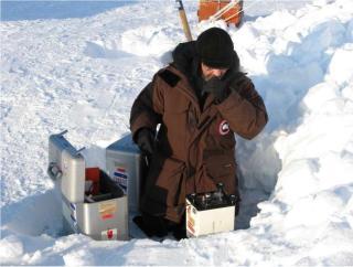
GSDs A. Belzile performed gravity measurements for the UNCLOS project. Gravity and depth measurements were taken as an adjunct to the seismic measurements. The slight wavy motion of the ice makes it hard to get a truly accurate measurement. In the 2009 survey, new Scintrex gravimeters were used successfully for the first time on Arctic ice.
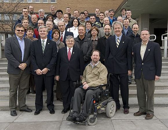
2009: Geodetic Survey Division (GSD) Centenary
April 20, 2009: GSD celebrates its Centenary.
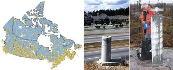
2009: Today's CACS
The Canadian Active Control System (CACS) consists of about 50 remotely controlled automated Global Navigation Satellite System (GNSS) tracking stations referred to as Active Control Points (ACPs), which continuously record signals for all navigation satellites within station view. Operated by GSD, the CACS provides improved GPS positioning capability for the Canadian surveying and geophysical communities as well as for other spatial referencing needs.
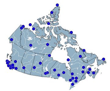
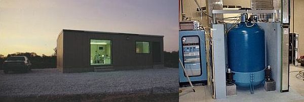
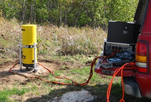
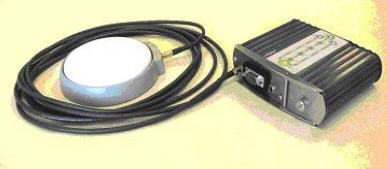
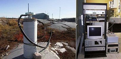
2009: Active Control Point (ACP)
Each ACP is equipped with a high precision dual frequency GPS receiver and an atomic frequency standard. The data collected at each ACP is retrieved on an ongoing basis, at intervals varying from a second to a day, by a central processing facility in Ottawa and made publicly available over the internet. The CACS is the modern approach to providing efficient access to national and international spatial reference frames (NAD83 (CSRS) and (ITRF)) to improve effectiveness and accuracy of GPS applications.
Page details
- Date modified: