
Canada Lands surveys: Tools and data
There are several ways to access survey information and datasets about Canada Lands. This page has information that will help you decide which one is best for you, access the information or dataset and use it optimally.
On this page
- Canada Lands Survey Records: Choose a tool
- Parcel and boundary datasets
- Oil and gas grid tools and data
- Managing a survey project
- Tips for viewing and downloading documents
Canada Lands Survey Records: Choose a tool
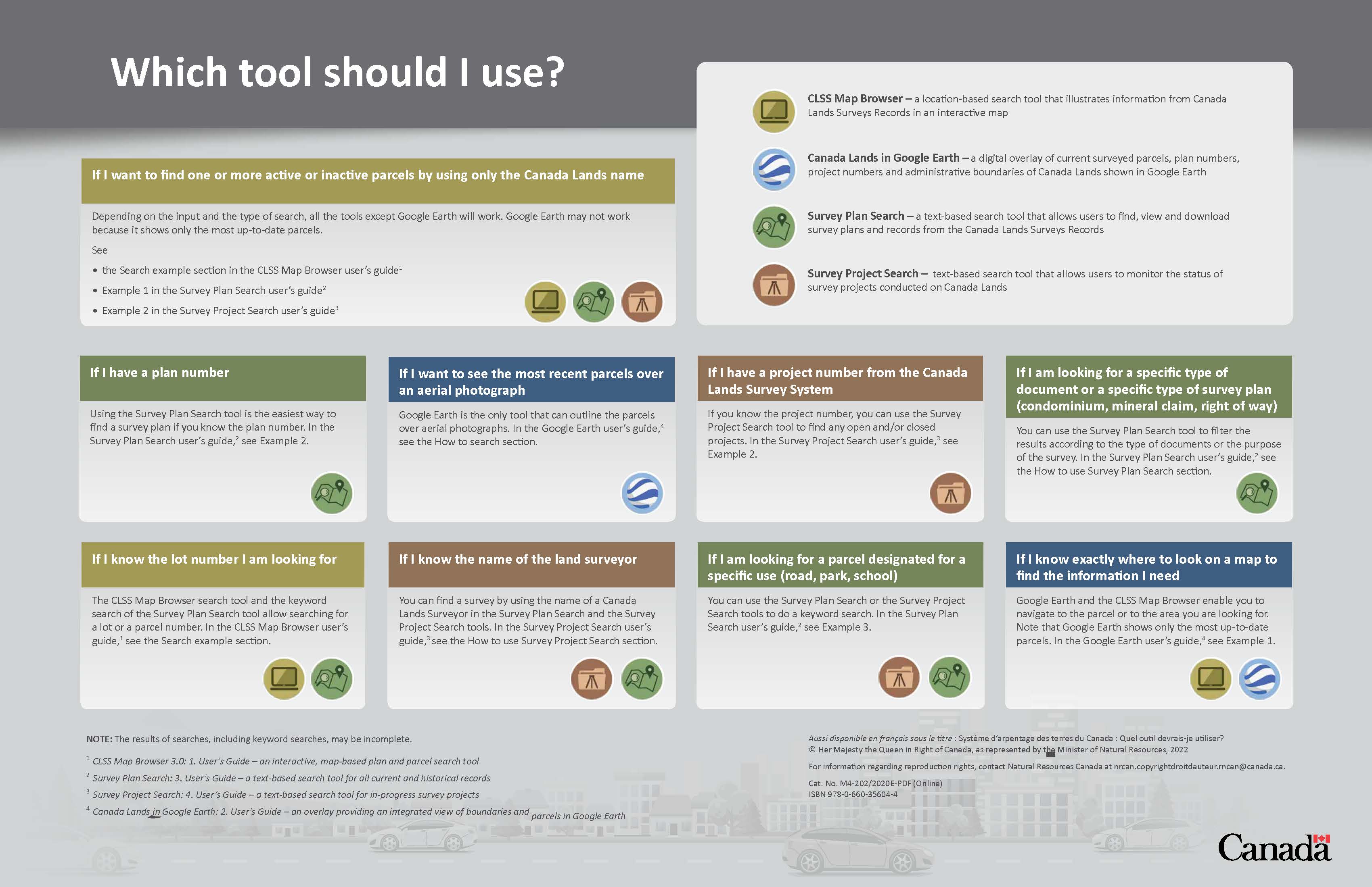
View or download Which Tool Should I Use? (PDF, 1.1 MB).
The Canada Lands Survey Records is a registry of legal survey documents. It contains survey plans, field notes, diaries, reports and other documents to support property rights on Canada Lands. These documents are available to land surveyors, land administrators and other stakeholders via the tools below.
Use the table below to determine which one(s) you should use.
See our service standards for details on the frequency of updates.
| Tool you use | ||||
|---|---|---|---|---|
| Survey Plan Search Text-based search tool that allows you to find, view, and download Canada Lands survey plans and records. User guide (PDF, 2.60 MB) |
Survey Project Search Text-based search tool that allows you to monitor the status of survey projects conducted on Canada Lands User guide (PDF, 2.47 MB) |
Canada Lands Survey System (CLSS) Map Browser Location-based search tool that presents Canada Lands survey records in an interactive map User guide (PDF, 3.17 MB) |
Canada Lands in Google Earth (KMZ, 421 bytes) A digital download overlay of current surveyed parcels, plan numbers, project numbers and administrative boundaries of Canada Lands shown in Google Earth User guide (PDF, 2.43 MB) |
|
| Your task | ||||
| Find one or more active or inactive parcels by using only the Canada Lands name | ||||
| Find records using a plan number | ||||
| See the most recent parcels over an aerial photograph | ||||
| Find an active project using a project number from the CLSS | ||||
| Find a specific type of document or a specific type of survey plan (condominium, mineral claim, right of way) | ||||
| Find records using a lot or parcel number | ||||
| Find a survey using the name of the land surveyor | ||||
| Find a parcel designated for a specific use (road, park, school) with a keyword search | ||||
| Find parcels by knowing exactly where to look on a map to find the information | ||||
| Download a plan | ||||
| Research a survey plan’s history | ||||
| Check for active survey projects and their status | ||||
| View parcels with surveys in progress | ||||
| Download a cadastral dataset | ||||
| Create custom PDF maps | ||||
Parcel and boundary datasets
We offer parcel and boundary datasets for use in a geographic information system (GIS). The Government of Canada’s Open Data portal also has products related to Canada Lands, including layers for Aboriginal lands, national parks and national park reserves.
Don’t use any of the datasets below to define boundaries. It’s important that you base your administrative decisions on legal survey plans and documents. When you download data, you agree with the Open Government Licence – Canada.
Canada Lands digital cadastral data
You can download free cadastral datasets with internal parcel data.
Coverage:
- By Canada Land (e.g., an Indian reserve or national park), province, territory (including offshore (Atlantic Ocean, Pacific Ocean, Hudson Bay)) or UTM zone (territories only)
Formats: ESRI Shapefile, ESRI FGDB, AutoCAD DWG
Updated: Weekly
Take me to HTTPS directories to download cadastral datasets
Some web browsers, like Google Chrome or Microsoft Edge, no longer support FTP. Try using an FTP client, like FileZilla or BulletProof FTP, or an older browser, like Internet Explorer, to access our FTP directories. We're working hard to fix this issue.
Canada Lands in Earth browsers
Use the Canada Lands overlay to view the administrative boundaries and cadastral parcels within Indian reserves, national parks and the territories. It works best with Google Earth 4.2 or later, but is also compatible with Google Maps, Microsoft Virtual Earth and NASA’s World Wind. Download the file and save it to “My places”, removing any older versions of Canada Lands. Once installed, you can access it by opening Google Earth from your desktop.
Coverage:
- One file for all of Canada
Format: KMZ (zipped KML)
Updated: Weekly
Download the Canada Lands overlay (KMZ, 421 bytes)
Note: The download links point to an FTP site. The default security settings in Google Earth don’t allow users to open these links directly from the application. There’s a workaround for downloading digital cadastral data on pages 20–21 of our Canada Lands in Google Earth user guide (PDF, 2.43 MB).
Administrative boundaries for Canada Lands
Our web mapping services provide national data of legislative boundaries for Aboriginal lands, national parks and national park reserves of Canada. They are available in ESRI REST and WMS formats using the Canada Atlas Lambert projection (EPSG:3979). All services are also available in the Open Maps community. Open Maps provides access to the Government of Canada’s geospatial information. You can combine, visualize and analyze geospatial data and collaborate with other Canadians. Alternatively, you can add the web map services in your GIS by using the links provided below.
Coverage:
- By province, territory or for all of Canada
Format: ESRI Shapefile, GML, KML, ESRI REST, WMS
Updated: Monthly
Legislative boundaries: Aboriginal lands of Canada
The Aboriginal Lands of Canada Legislative Boundaries web service uses polygon entities to depict the administrative boundaries of lands set aside for specific Aboriginal groups in Canada.
Open Maps (includes metadata)
ArcGIS Server (ESRI REST) — ENGLISH
ArcGIS Server (ESRI REST) — FRENCH
Web Mapping Service (WMS) Server — ENGLISH
Web Mapping Service (WMS) Server — FRENCH
Legislative boundaries: National parks and national park reserves of Canada
Open Maps (includes metadata)
ArcGIS Server (ESRI REST) — ENGLISH
ArcGIS Server (ESRI REST) — FRENCH
Web Mapping Service (WMS) Server — ENGLISH
Web Mapping Service (WMS) Server — FRENCH
Oil and gas grid tools and data
Oil and gas grid converter tool
Use this tool to compute the North American Datum of 1983 (NAD83) coordinates and surface areas for the corresponding North American Datum of 1927 (NAD27) grid areas, sections and units.
Take me to the oil and gas grid converter tool
Well offsets tool
Use this tool to compute the offset of a point on the NAD83 datum (with respect to the unit boundaries in which it’s located) and the corner coordinates and boundary azimuths for the corresponding grid area, section and unit.
Take me to the well offsets tool
Oil and gas grid data
This is a dataset of the land division system in NAD83 coordinates available for oil and gas exploration and regulations. It has three layers: grid areas, sections and units.
Coverage: The data is contained in 116 ZIP files that are stored in folders representing six regions:
- AT: Atlantic Ocean south of 60° N
- PA: Pacific Ocean
- HB_BH: Hudson Bay south of 60° N
- NT_TNO: Northwest Territories
- NU_E: Nunavut east of 85° W and north of 60° N
- NU_W_O: Nunavut west of 85° W and north of 60° N
There are no overlaps between regions. A grid area on the boundary between two regions is included in only one ZIP file, which is named as follows:
- OG-PG_<region>_<latitude>_<edition>_<version>.zip
- OG-PG: Abbreviated English and French title of product
- <region>: Code of region as indicated above
- <latitude>: Degree of latitude of the grid areas included in the file. Values range from 38 to 84
- <edition>: Dataset edition number
- <version>: Dataset version number
Format: ESRI Shapefile
Updated: N/A
Download the grid data in Shapefile™ format from the HTTPS site
Some web browsers, like Google Chrome or Microsoft Edge, no longer support FTP. Try using an FTP client, like FileZilla or BulletProof FTP, or an older browser, like Internet Explorer, to access our FTP directories. We're working hard to fix this issue.
Note: Each ZIP file contains ESRI Shapefiles for grid areas, sections and units as well as the associated metadata files in English and French in XML and HTML formats. You can access FTP help and FTP software on the GeoGratis website.
Managing a survey project
If you’re a surveyor, use the MyCLSS website to complete these tasks:
- Initiate a survey project
- Request survey instructions
- Use online tools to help produce official plans
- Monitor project status through to completion
- Submit digitally signed survey documents for recording
- Obtain approvals
National Standards for the Survey of Canada Lands
Are you a professional Canada Lands surveyor? If so, you’ll need to access the current general instructions of the Surveyor General of Canada Lands in this document. It contains the technical standards that apply to surveys undertaken on Canada Lands and for lands that must be surveyed under the Canada Lands Surveys Act.
Take me to the National Standards
Tips for viewing and downloading documents
Check out these tips for viewing and downloading survey plans, maps and other documents.
Large survey plan images
Some image viewing software cannot render survey plan TIFF or JPG images that are relatively large in scale or in file size (> 8 MB). It could appear to be blank when, in fact, the data simply cannot be displayed. Consider downloading free image viewing software that is capable of viewing these types of images, such as IrfanView.
DjVu files
Some of our scanned survey plans and related documentation are available in DjVu format where file sizes are large and high file compression is required. To view DjVu files, download the free DjVu viewer.
PDF files
Some of our cadastral related documentation and maps are available in PDF format. To view PDF files you need Acrobat Reader 6.0 (or later). If the Adobe download site is not accessible to you, you can download Adobe Reader from an accessible page. If you choose not to use Acrobat Reader, you can convert the PDF file to HTML or ASCII text by using one of the conversion services offered by Adobe.
Page details
- Date modified: