
Orienting a Topographic Map
A map is oriented when it is made to correspond to the ground it represents. Remember, on a topographic map, north is the top of the map.
There are four ways to orient a map:
I. BY COMPASS
With a protractor, draw a magnetic north line anywhere on your map. The declination diagram in the margin of the map will give you the direction and size of the angle between grid north and magnetic north.
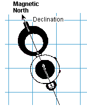
Diagram I - Orienting a map using a compass
Do not use the margin diagram itself as the angles are often exaggerated by the cartographer so that the numerical values for the angle can be inserted.
Place the compass on the magnetic north line and turn the map and compass together slowly until the needle points to magnetic north on the map.
The adjacent Diagram I shows a compass, oriented to north, placed on top of a line drawn on the map pointing to magnetic north.
II. BY DISTANT OBJECTS
If you know your position on the map and can identify the position of some distant object, turn the map so that it corresponds with the ground.
As shown in Diagram II below, the map reader uses a church, identified by eye and on the map, to orient the map to the ground.
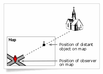
Diagram II - Orienting a map by an object
III. BY WATCH AND SUN - (in the Northern Hemisphere)
If Daylight Saving Time is in effect (in summer), first set your watch back to Standard Time. Place the watch flat with the hour hand pointing toward the sun. True South is midway between the hour hand and XII. True North is directly opposite. Note; this method is very approximate.
Diagram III below shows a watch with the hour hand pointing to "3" and pointing to the sun. South is therefore determined to be midway between "12" and "3".
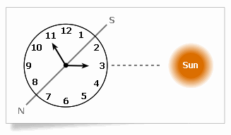
Diagram III - Orienting by a watch and the sun
IV. BY THE STARS
In latitudes below 60° North, the bearing of Polaris is never more than 2° from True North.
Diagram IV below shows how to locate Polaris using the two stars that form the front of the "dipper" of the Big Dipper. Polaris can be found at the end of a line that joins these two stars that is extended beyond the open end of the dipper at a distance 5 times the distance between these two stars.

Diagram IV - Orienting by the stars
These constellations revolve counter-clockwise around the Pole.
Find out more
Page details
- Date modified: