
ARCHIVED - Oak Ridges Moraine research contributes to Ontario water-resource management and land-use policy
Information Archived on the Web
Information identified as archived on the Web is for reference, research or recordkeeping purposes. It has not been altered or updated after the date of archiving. Web pages that are archived on the Web are not subject to the Government of Canada Web Standards. As per the Communications Policy of the Government of Canada, you can request alternate formats. Please "contact us" to request a format other than those available.
Freshwater: The Role and Contribution of Natural Resources Canada
The Geological Survey of Canada's (GSC) recently completed work on Oak Ridges Moraine (ORM) groundwater systems continues to impact land-use planning and water-resource policy implementation in Ontario. The Oak Ridges Moraine is provincially significant as it supplies groundwater to ~200,000 residents, contributes up to 50 percent of yearly flow in 30 streams and sustains a vibrant habitat and cold-water fishery across regional watersheds. The GSC research team assisted Ontario agencies, private-public sectors and academia by providing critical data, approaches and results so that recent water-resource knowledge supports official plans and zoning bylaws linked to a new ORM planning policy.[11]
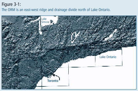
GSC efforts have contributed new mapping and 3-D models, for example (Fig. 3-1), to regional watershed planning and sustainable water-resource management in ORM aquifers. The basin analysis study approach (Fig. 3-2) demonstrated the value of investment in both high-quality 3-D data collection and in a regional watershed focus.
Moreover, the ORM study continues to show positive outcomes from ongoing collaboration with provincial, municipal and other agencies as part of a national framework to address water-resource priorities.
The provincial Ministry of Housing and Municipal Affair's Director of Planning praised GSC research for assisting provincial efforts to protect and manage ORM water resources. Particular praise was extended for high-quality scientific evidence and professional conduct at Ontario Municipal Board hearings to urbanize sensitive ORM groundwater recharge areas.
The scientific credibility that the GSC contributed to the hearing's central water-resource issues helped this landmark case lead to the Oak Ridges Moraine Conservation Act.[12] The Province is using the ORM research methods and models in practical ways to help all stakeholders improve their understanding and management of the area's water resources. GSC efforts have also been instrumental in both imparting knowledge and raising awareness of groundwater science by communicating [13] to many, including provincial agencies, municipalities, and, public and educational communities.
Current impact of the GSC work on the ORM for Ontario users:
- ORM mapping protocols are being used in a $10 million municipal groundwater-protection program across southern Ontario.
- A coalition of nine ORM conservation authorities and three regional municipalities contracted GSC to produce 3-D models (Fig. 3-2) to support groundwater/surface-water management.
- Canadian Geographic and the Toronto Star editorial page highlighted GSC expertise to national/area audiences with articles and photo essay on the Oak Ridges Moraine studies.
- Ontario agencies continue to engage GSC as partners in regionally based groundwater science that supports water-resource policy and management issues across Ontario.
- ORM experience is being used by GSC study team to provide technical advice regarding Ontario's ground-breaking initiatives on Source Water Protection.[14]
Notes:
11 Oak Ridges Moraine Conservation Plan: http://www.mah.gov.on.ca/userfiles/HTML/nts_1_6850_1.html Back to text.
12 Oak Ridges Moraine Conservation Act: http://www.ontla.on.ca/library/bills/122372.htm Back to text.
13 Oak Ridges Moraine web site: http://sts.gsc.nrcan.gc.ca/orm/index.asp Back to text.
14 Ontario Source Water Protection-Technical report: http://www.ene.gov.on.ca/envregistry/024326ex.htm Back to text.


Page details
- Date modified: