
Volcanoes in Canada: Are they ready to rumble?
By Danielle Gravesande
July 19, 2018
The last time a volcano erupted in Canada was 150 years ago. But it will happen again.
When the Lava Fork volcano in northwest British Columbia erupted, a 22-kilometre lava flow crossed into Alaska, damming the Blue River and creating many small lakes. Since then, Canada has witnessed minimal volcanic activity.
To ensure that Canadians are as ready as can be for the next one, NRCan volcanologist Melanie Kelman is monitoring activity and modelling hazards at the two volcanoes located closest to populated areas in Canada
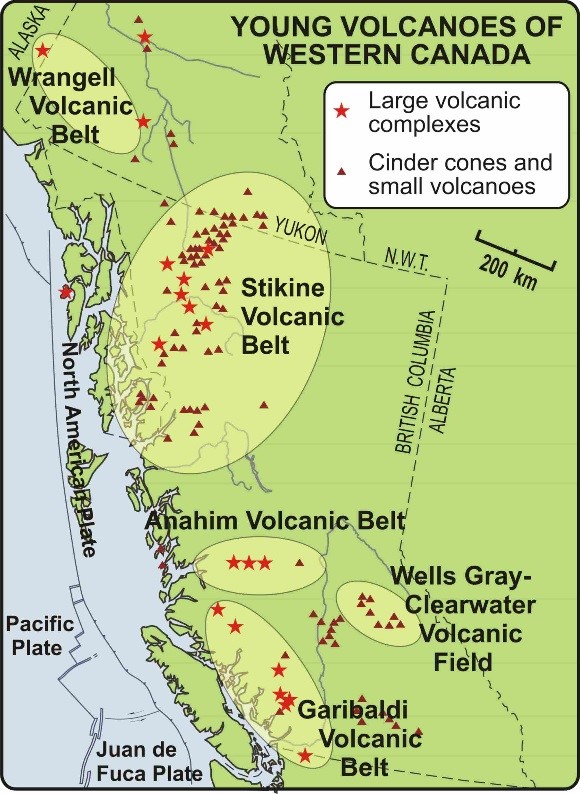
Larger image
A map of young volcanoes in Western Canada. The map identifies five key areas: Wrangell Volcanic Belt, Stikine Volcanic Belt, Anahim Volcanic Belt, Wells-Gray Clearwater Volcanic Field and Garibaldi Volcanic Belt.
Where are Canada’s volcanoes?
Canada has five potentially active volcanic areas, all in B.C. and Yukon . Dr. Kelman is focusing her research on Mounts Cayley and Garibaldi — two stratovolcanoes located within 150 km of Vancouver and closer still to Squamish, a town of about 20,000 people. They might look like ordinary mountains, but these volcanoes could be trouble for people, wildlife, roads and landscape.
“We typically divide things into stratovolcanoes — such as Mounts Garibaldi and Cayley — and shield volcanoes, which is what you see in Hawaii,” says Dr. Kelman. Many of the volcanoes in B.C.’s Lower Mainland are stratovolcanoes. With thick, viscous lava that flows very slowly and allows gas pressure to build up inside, stratovolcanoes can trigger debris flows and volcanic ash emissions, which pose serious threats to surrounding environments.
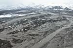
Larger image
Lahar and flood deposits spreading across the fan at the mouth of Drift River Valley. 2009 Photo Credit: Cyrus Read, Alaska Volcano Observatory / U.S. Geological Survey
Hazards that flow and hazards that fly
Although lava may be the most widely known volcanic hazard, it is not the only hazard that Canadian volcanoes are known to emit, nor is it the most prevalent. Dr. Kelman is examining the threat posed by lahars: a type of debris flow comprising loose volcanic rock mixed with ice, snow or surface water.
Lahars can travel tens of kilometres at speeds up to 80 kilometres an hour. The threat of a lahar forming is always present at many stratovolcanoes, even in the absence of volcanic activity. Steep, unstable rock slopes or debris that has accumulated on a steep volcano can mix with water and snow, flowing freely without warning.
A 2010 eruption in Iceland showed the world just how big a problem airborne volcanic ash can be : transatlantic flights were disrupted for weeks , and homes, roads and crops were damaged. Volcanic ash — slightly corrosive, hard, electrically charged and unable to dissolve in water — can cause respiratory issues, destroy food sources for wildlife and damage mechanical devices like computers, power distributors and even airplanes.
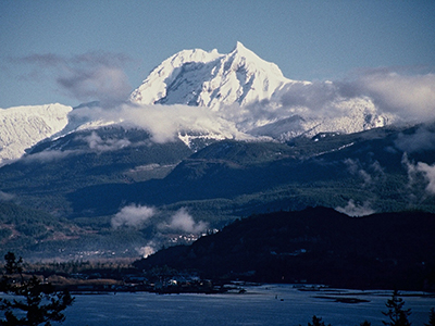
Larger image
Mount Garibaldi
Monitoring and modelling at Cayley and Garibaldi
Most volcanic activity is so small that it is invisible to the naked eye. At her station in Vancouver, Dr. Kelman and seismologists use Natural Resources Canada’s regional seismic network to watch for the swarms of many tiny earthquakes that would likely precede volcanic activity at Mounts Cayley and Garibaldi.
Another technique NRCan is planning to incorporate into its routine volcano monitoring is interferometric synthetic aperture radar (InSAR), an innovative satellite technique that identifies changes in the ground surface surrounding a volcano, down to the millimetre. These changes are due to underground movements of magma — lava that has yet to reach the surface . Unlike seismic instruments, InSAR does not rely on in-field personnel and equipment, allowing researchers to monitor multiple areas at relatively low cost without risk to people or equipment and, used together with seismic monitoring, providing a much clearer picture of what is happening at a volcano.
“We’re kind of looking at it from two directions,” says Dr. Kelman. “If something goes wrong with the seismic monitoring, we’d still have InSAR or vice versa . If there’s somehow a delay in processing the InSAR data, we still have our seismic network.”
Another important aspect of Dr. Kelman’s research is modelling lahar debris flow to determine what would happen if Mounts Cayley or Garibaldi were to erupt. To do this, she uses Laharz software that applies a digital elevation model and a user-specified lahar volume to create a model of where a lahar might form in the case of volcanic activity.
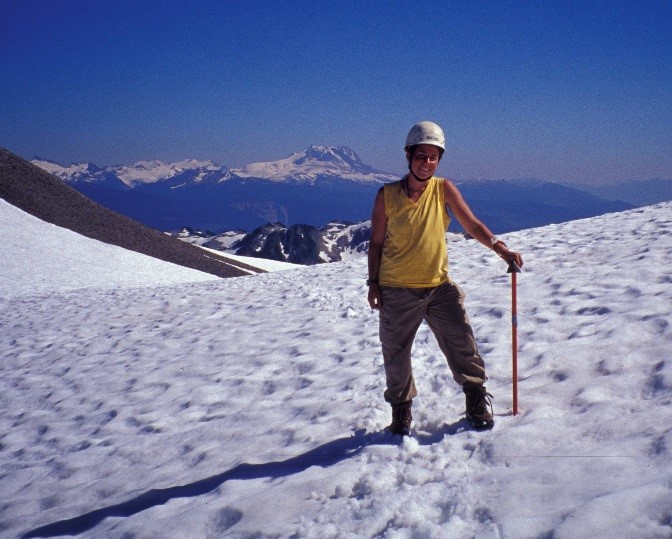
Larger image
Dr. Kelman with Mount Garibaldi
“Although there are more sophisticated ways to model lahar behaviour, I am using Laharz because I have so little information and I don’t want to make a lot of assumptions,” says Dr. Kelman. “We don’t know the probability of lahars , but a good starting point is determining what areas could be affected by a certain volume of lahar.”
If the unthinkable were to happen
If a volcano were to erupt in Canada, seismologists such as Dr. Kelman would play an integral role in the crisis management process, providing first responders with important data on what to expect. This data would inform critical decisions on evacuation and other emergency measures.
As one of Canada’s few volcanologists, Dr. Kelman’s unique research is helping Canadians better understand the hazards in their backyard. “We’ve got this incredible geological laboratory in Canada,” she says. “There’s all these exciting processes you can study, and to me, that’s the big point.”
Related stories
Page details
- Date modified: