
Experts in groundwater, vegetation, forestry, wetlands and landscapes work together for a common goal
It grew from a study of oil and gas impacts on aquifers to become a multidisciplinary project involving 20 experts from various backgrounds.
November 2021
Christine Rivard is a Québec City–based hydrogeologist with the Geological Survey of Canada (GSC). For her, studying how water seeps into the ground and flows through the soil and rock is all part of a day’s work to better understand the dynamics of groundwater and aquifers. For 10 years, she studied the potential impacts of oil and gas activities on shallow groundwater, with a primary focus on Eastern Canada. Then in 2019, she turned her attention to one of the most intensive energy production areas of the last 50 years in Western Canada: Fox Creek.
.png)
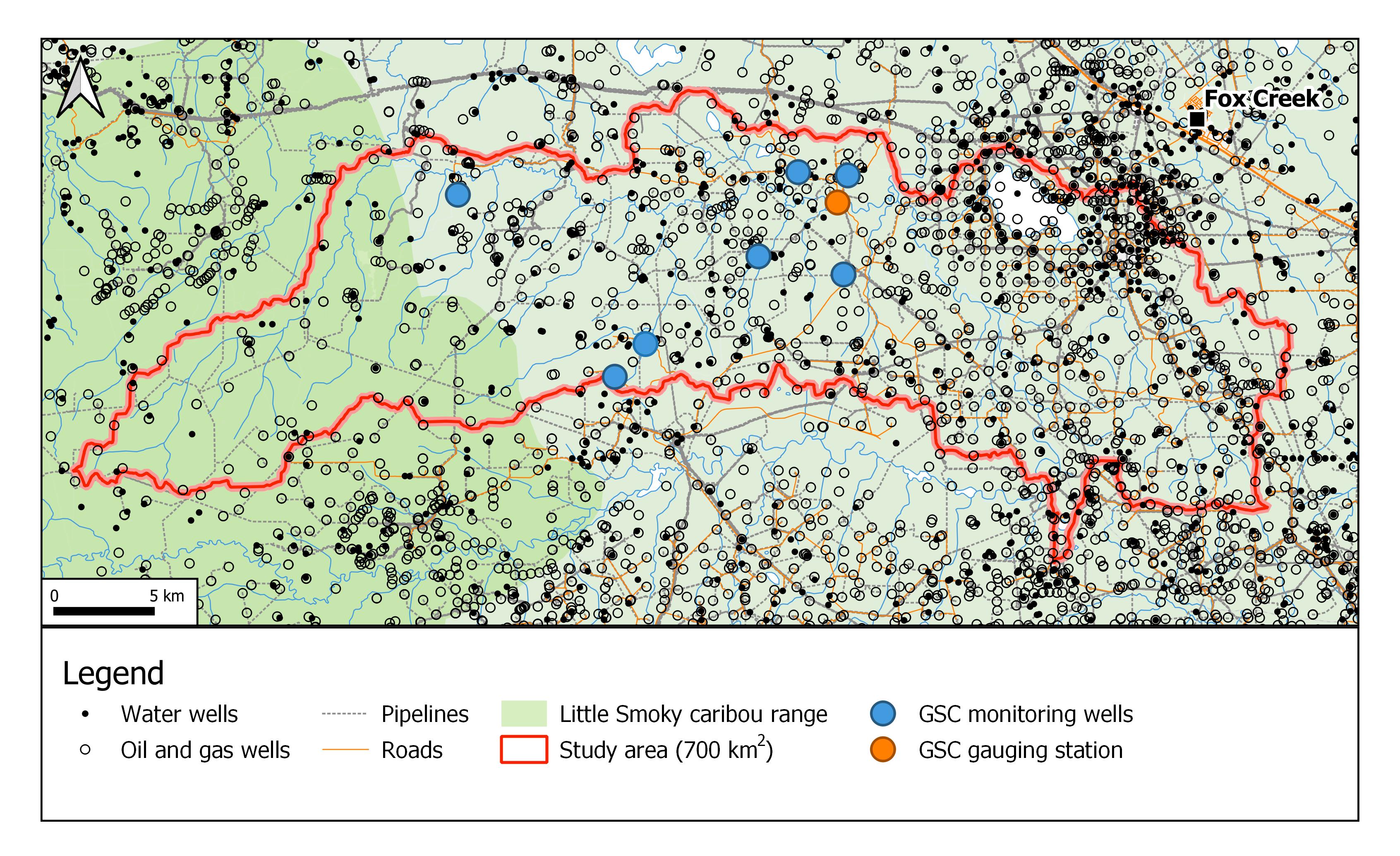
The Paskapoo Formation covers a vast portion of Alberta, from northwest of Edmonton down to Calgary.
Dr. Rivard wanted to explore the potential impacts of decades of industrial activity on shallow groundwater in the west-central part of Alberta. The regional bedrock aquifer in this area is the Paskapoo Formation, a vast geological unit that is the most important groundwater supply in the Canadian Prairies.
Of particular interest was that the Fox Creek area, at the northern tip of the formation, experienced a significant increase from 2013 to 2017 in the frequency of earthquakes due to hydraulic fracturing operations. In 2017, the GSC collaborated with other specialized partners to develop a tool to help the industry limit the seismicity that is often induced by hydraulic fracturing, which involves injecting water, chemicals, and sand at high pressure to extract oil and natural gas.
Evaluating big-picture issues
While industrial hydrocarbon exploration and production activities have been declining in the past few years due to lower natural gas prices, the region was still of great interest for environmental studies.
The initial focus was on a specific area of hydrogeology. But when Natural Resources Canada (NRCan) identified this area as a possible location of interest to develop new evaluation methods for cumulative effects, Christine widened the scope of the project and called on the expertise of specialists in other areas from federal and provincial governments and academia. Soon, she was leading a group of 20 experts, all of them focused on Fox Creek to study its groundwater, rocks, vegetation, forests, wetlands and landscape features.

Cumulative effects are caused by the repetition or combination of one or more stressors caused by humans or nature over time. Causes might include resource development, energy production, wildfires, forest pest infestations, climate change and urban expansion.
This holistic approach, increasingly adopted in research projects, is clearly necessary because of the dynamic and often complex interrelationships between the factors involved in a particular region.
“The importance of studying cumulative effects is the fact that the impacts of several actions or activities in a given region — when combined — can have a greater impact than those resulting from individual actions,” says Christine. Past, present, and potential future activities are all important to consider when evaluating cumulative effects.
The benefits of this multidisciplinary approach are many. “Federal government leadership through these different projects will help fill data and knowledge gaps,” she adds. “For example, we are continuing to advance our knowledge of how best to conduct complex regional assessments of cumulative effects. As a result, these studies will not only help us better manage our resources, they’ll also help the proponents and their consultants to better conduct environmental assessments.”
Work well underway below and above ground
Crews drilled nine shallow monitoring wells in the fall of 2020, one of which is located alongside a gas well. This activity was significant in itself, since it marked the first time the oil and gas industry in Western Canada allowed a federal government environmental project to place a monitoring device on an active well pad.
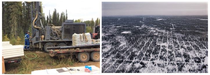
Left: a crew drills shallow wells near Fox Creek to monitor groundwater and characterize the aquifer. Right: Linear features such as seismic lines alter local land use patterns and affect wildlife habitats.
While it’s only three years into the five-year project, the results are already coming in, despite a slowdown in field activities due to the COVID-19 pandemic.
In addition to the collection of hydrogeological and geochemical data, another team is closely monitoring the levels of snow cover and soil moisture in both unimpacted forested areas and impacted areas, such as well pads, old seismic lines and along pipelines.
The results to date are encouraging with regard to groundwater and the health of the environment: preliminary two-dimensional hydrogeological modelling and geochemical data suggest that the Paskapoo Formation is well protected from deep industrial activities. As for the project’s next steps, ongoing 3D geomechanical models will help scientists understand how underlying rock formations protect shallow aquifers as they respond to changes in stress and pressure during hydraulic fracturing and other reinjection activities.
On the wider question of how the landscape has evolved over five decades of industrial activity, researchers are looking at linear features such as access roads, pipelines, and seismic lines as well as in the natural features of streams, wetlands and forests — all of which affect wildlife habitats.
An example of the kind of information that will be available on the Open Science and Data Platform.
Get updates online
All this work is clearly important, and its results will be available on the Government of Canada’s Open Science and Data Platform (OSDP), which provides online access to cumulative effects–related science products like maps, publications, and data from across the country. Here, you can find thousands of scientific products, including Christine’s recent 2021 publication.
Informing industry, decision makers and Canadians
Cumulative effects in Canada are usually considered on a case-by-case basis, as for example when a new mine is being planned or an existing one is expanding. However, the impacts of numerous activities—such as logging, commercial fishing, mining, hunting, recreation, and human settlement—all accumulate across time and space in a given area.
As a result, modern science recognizes that a comprehensive, wide-ranging, long-term view of these activities is essential. “Considering them together is a big challenge, and we are only at the beginning of our ability to do so,” says Christine. “However, we will surely be able to accomplish great things together in the years to come.”
- Alberta Energy Regulator/Alberta Geological Survey
- Alberta Environment and Parks
- University of Alberta
- Quebec’s Institut national de la recherche scientifique - Centre Eau Terre Environnement
- Université Laval
- Northern Alberta Institute of Technology
- Natural Resources Canada – CanmetENERGY
- Natural Resources Canada – Canadian Forest Service – Great Lakes Forestry Centre, Northern Forestry Centre
- Natural Resources Canada – Canada Centre for Mapping and Earth Observation – Canada Centre for Remote Science
For more information:
Explore:
Christine Rivard’s profile on Science.gc.ca
Open Science and Data Platform
Read:
New induced seismicity study: fracking and earthquakes in Western Canada
Watch:
Assessment of potential impacts of oil and gas development activities on shallow aquifers in the Fox Creek area (AB) (May 2021 update)
Related stories
Page details
- Date modified: